Species and habitats - Sedimentary cover of the English Channel done during recent surveys (1998-2007)
Granulometric characteristics were determined for each station sampled during different recent surveys.
Simple
- Title
-
Species and habitats - Sedimentary cover of the English Channel done during recent surveys (1998-2007)
- Alternate title
-
newsurveys_environment_geostatP
- Alternate title
-
CHARM_SEDIM_VARIOUS_R
- Date (Publication)
- 2009-12-31T00:00:00
- Citation identifier
- CHARM_SEDIM_VARIOUS_R
- Presentation form
- Digital map
- Other citation details
-
Source CHARM Consortium
- Abstract
-
Granulometric characteristics were determined for each station sampled during different recent surveys.
- Credit
-
Station Marine de Wimereux, Université des Sciences et Technologies de Lille
- Credit
-
CHARM Consortium
- Status
- Completed
- Point of contact
-
Organisation name Individual name Electronic mail address Role Station Marine de Wimereux, Université des Sciences et Technologies de Lille
Jean-Marie Dewarumez
Local service desk
- Maintenance and update frequency
- As needed
-
Thèmes Sextant
-
-
/Physical Environment/Geology/Mineral Resources
-
- Theme
-
-
Environment data set
-
CHARM
-
-
GEMET - INSPIRE themes, version 1.0
-
-
Habitats et biotopes
-
-
external.theme.gemet
-
-
sédimentologie
-
- Use limitation
-
research-only
- Access constraints
- License
- Other legal constraints
-
Has to be cited this way in maps : "Source CHARM Consortium"
- Other legal constraints
-
Has to be cited this way in bibliography : "Carpentier A, Martin CS, Vaz S (Eds.), 2009. Channel Habitat Atlas for marine Resource Management, final report / Atlas des habitats des ressources marines de la Manche orientale, rapport final (CHARM phase II). INTERREG 3a Programme, IFREMER, Boulogne-sur-mer, France. 626 pp. & CD-rom"
- Spatial representation type
- Grid
- Denominator
- 1000
- Language
- Français
- Language
- English
- Character set
- UTF8
- Topic category
-
- Imagery base maps earth cover
- Oceans
- Geoscientific information
- Environment description
-
Microsoft Windows XP ; ESRI ArcGIS 9.x
- Geographic identifier
- Eastern English Channel
))
- Begin date
- 1998-01-01
- End date
- 2007-12-31
- Reference system identifier
- 4326
Distributor
- Distributor contact
-
Organisation name Individual name Electronic mail address Role Ifremer - Centre de Brest
Dissemination Unit
- Distributor format
-
Name Version
- OnLine resource
-
Protocol Linkage Name OGC:WMS
https://sextant.ifremer.fr/services/wms/wms_charm? CHARM_SEDIM_VARIOUS_R
WWW:LINK
http://www.ifremer.fr/charm/ COPYFILE
Sedimentary cover
- Hierarchy level
- Dataset
- Statement
-
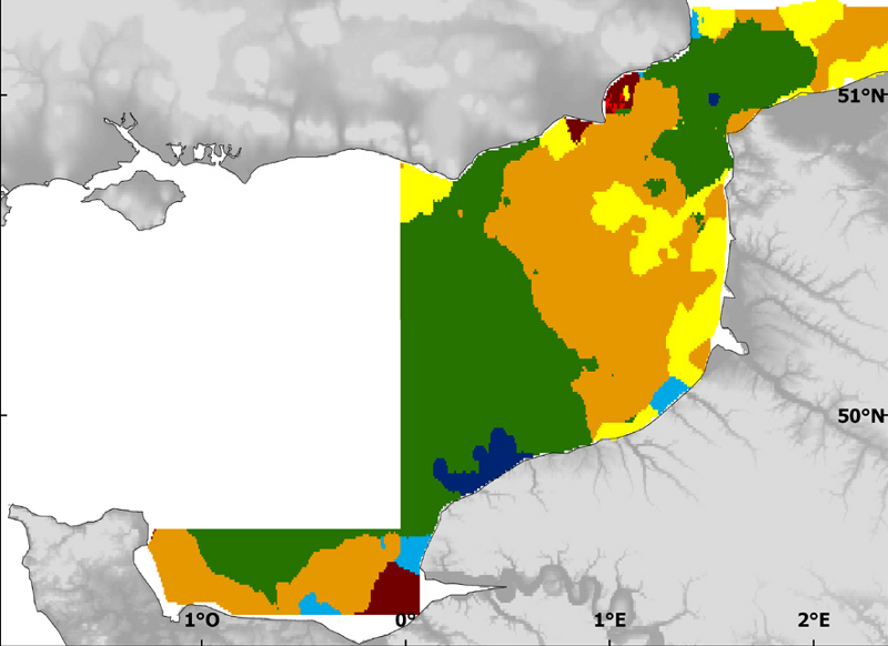
In 2006 and 2007, MABEMONO program (acronym MAcroBEnthos of the eastern English Channel and the south of the North Sea) was leaded in the Marine Station of Wimereux : sampling regular (a station each 5' in latitude and longitude) -more intense in the area of the Flanders sand banks (southern Bight of the North Sea, the sand banks in the south of the Dover Strait and the Ridens area, with a smaller spatial scale) / quantitative samples collected by a Hamon grab (or when impossible, the ¿Rallier du Baty¿ dredge) /At sampled stations, a grab (or dredge) was taken for the measure of sediments characteristics. A sub-sample of this grab (or dredge) was taken. Then, at the laboratory, the granulometric analysis consists in: (1) rinsing the samples with water in order to eliminate salt (which could form a crust during the following steps); (2) drying the sediment in an oven for at least 24 h; (3) sieving the samples through a range of 18 sieves organised in 3 sieving columns, in decreasing order of mesh size ; (4) weighing the remaining sediment in each sieve to an accuracy of 0.01 g.
- Description
-
Each granulometric characteristics associated with stations wete then analysed with the Folk classification and separated in seven categories : (1) pebbles which correspond to a part of the "G" category of Folk classification ; (2) gravels which contains the remaining of the "G" category plus the "sG" category of Folk classification; (3) heterogenous gravels which are a combination of the "msG" and "gmS" categories of Folk classification; (4) coarse sand which corresponds to the "gS" and "(g)S" categories of Folk classification; (5) medium sand which is the "S" category of Folk classification; (6) Muddy-fine sand which is the "mS" category of Folk classification and (7) heterogenous sand which are a combination of "(g)mS" and "(g)sM" categories of Folk classification. These seven cetagories were then mapped by binary kriging.
- Description
-
Copale-Authie surveys, Bay of Seine survey, MODIOLES surveys and MABEMONO surveys, scientific surveys from SMW.
Metadata
- File identifier
- e728a450-0140-11e0-abec-005056987263
- Metadata language
- English
- Character set
- UTF8
- Hierarchy level
- Dataset
- Date stamp
- 2024-04-05T09:31:37.759Z
- Metadata standard name
-
ISO 19115:2003/19139 - SEXTANT
- Metadata standard version
-
1.0
- Metadata author
-
Organisation name Individual name Electronic mail address Role Ifremer
Sandrine Vaz
Local service desk
accessData
Overviews
)))