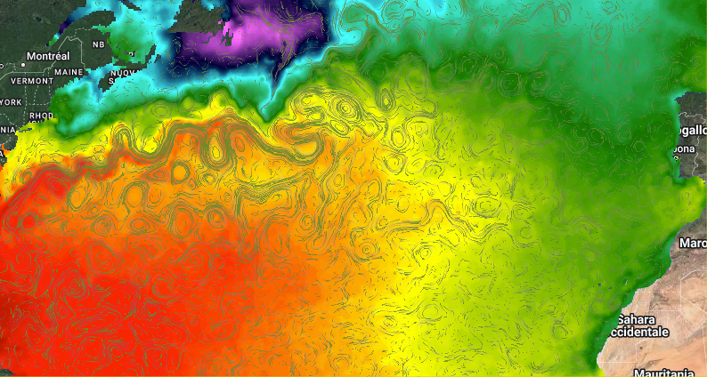
WOC North Atlantic 2-D Merged SSH/SST currents
This dataset provides a level 4 (L4) gap free reconstruction of 2D ocean surface currents obtained through the combination of altimeter-derived geostrophic currents and satellite sea surface temperature (SST) L4 data. This WOC product uses the standard Altimeter-derived geostrophic currents (Copernicus operational product, ¼°) as background information and extracts additional dynamical information from the spatial and temporal gradients of a higher-resolution (HR) satellite-derived SST field (Copernicus OSTIA product, remapped onto a 1/10° grid). In particular, the patterns found in the HR satellite SST enable to compute correction factors that are assigned to the background geostrophic currents provided by the Altimeter system.
The data are available through HTTP and FTP; access to the data is free and open. In order to be informed about changes and to help us keep track of data usage, we encourage users to register at: https://forms.ifremer.fr/lops-siam/access-to-esa-world-ocean-circulation-project-data/
This dataset was generated by CNR (Consiglio Nazionale Ricerche) and is distributed by Ifremer / CERSAT in the frame of the World Ocean Circulation (WOC) project funded by the European Space Agency (ESA).
Simple
Identification info
- Date (Creation)
- 2022-02-10
- Date (Publication)
- 2020-02-10
- Citation identifier
- WOC-L4-CUR-NATL2D_REP-1D
- Status
- Completed
- Point of contact
-
Organisation Individual Electronic mail address ORCID Role CNR
Daniele Ciani Consiglio
Author CERSAT / Ifremer
Point of contact CNR
Daniele Ciani Consiglio
Originator CERSAT / Ifremer
Distributor European Space Agency (ESA)
Funder
- Spatial representation type
- Grid
Spatial resolution
- Spatial resolution
- 0.1 degree
- Temporal resolution
-
P0Y0M1DT0H0M0S
- Topic category
-
- Oceans
Extent
))
- Geographic identifier
- North Atlantic
Extent
- Time period
- 2010-01-01 2019-12-31
- GEMET - INSPIRE themes, version 1.0
-
-
Oceanographic geographical features
-
- Cersat - Parameter
-
-
Ocean currents
-
- Cersat - Project
-
-
WOC
-
- Cersat - Latency
-
-
Historical
-
- Cersat - GCMD parameter
-
-
/Ocean Circulation/Ocean Currents
-
- Centre de données ODATIS
-
-
CDS-CERSAT
-
- Type de jeux de donnée ODATIS
-
-
/Observational data/satellite
-
Resource constraints
- Use limitation
-
None
- Access constraints
- Unrestricted
- Use constraints
- Other restrictions
- Other constraints
- CC-BY (Creative Commons - Attribution)
- Other constraints
-
CNR. 2022. North Atlantic Data-Driven 2D Surface Currents from ESA WOC project. Ver. 2.0. Obtained from CERSAT / Ifremer, Plouzane, France. Dataset accessed [YYYY-MM-DD].
Associated resource
- Association Type
Content Information
- Processing level code
- L4
Distribution Information
- Distribution format
-
-
NetCDF
-
- Distributor contact
-
Organisation Individual Electronic mail address ORCID Role
- OnLine resource
-
Ifremer HTTP server
HTTPS
- OnLine resource
-
Ifremer FTP server
FTP
- OnLine resource
-
User guide
Product User Manual
- OnLine resource
-
Processing and validation
Algorithm Theoretical Basis Document
- OnLine resource
-
Digital Object Identifier (DOI)
Data quality info
- Hierarchy level
- Dataset
Reference System Information
- Reference system identifier
- http://www.opengis.net/def/crs/EPSG/0/4326
- Hierarchy level
Extent
- Description
-
grid
- Instrument
-
Instrument Platform
Metadata
- Metadata identifier
- urn:uuid/e84fe404-1ed3-4e6f-9b72-f75cd8eb7f7d
- Language
- English
- Character encoding
- UTF8
- Contact
-
Organisation Individual Electronic mail address ORCID Role CERSAT Exploitation
Editor
Type of resource
- Resource type
- Dataset
- Metadata linkage
-
https://sextant-test.ifremer.fr/geonetwork/srv/api/records/c37b183e-0257-401d-b09d-3e8b0697887f
- Date info (Revision)
- 2024-10-15T14:57:46.591386Z
- Date info (Creation)
- 2022-04-20T16:51:22.619Z
Metadata standard
- Title
-
ISO 19115-3:2018 - Remote Sensing
accessData
Overviews
Spatial extent
)))