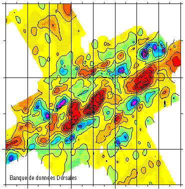
Magnetic Anomaly - Mohns Ridge 71.75°-73°N - 900m
Magnetic data of the ridge axis of Mohn's ridge (NE Atlantic) in order to study the mecanisms of the oceanic accretion.
Simple
- Title
-
Magnetic Anomaly - Mohns Ridge 71.75°-73°N - 900m
- Date (Creation)
- 1994-01-11
- Citation identifier
- IFR_MBAN_DORSALES_MOHN_GRAVI_RESI_900_R
- Citation identifier
- DOI:10.12770/e93ba182-b8d5-4abd-a2a8-07ddf9553fc5
- Abstract
-
Magnetic data of the ridge axis of Mohn's ridge (NE Atlantic) in order to study the mecanisms of the oceanic accretion.
- Credit
-
The project is part of the national program Dorsales and represents the French contribution to the InterRidge Data Banks project (see InterRidge News 1997, vol. 6/1 and 1999, vol. 8/1).
- Point of contact
-
Organisation name Individual name Electronic mail address Role Ifremer
Publisher Lab. de Pétrologie – CNRS/UPMC
Rommevaux-Jestin Céline
Author
-
Thèmes Sextant
-
-
/Physical Environment/Geology
-
-
GEMET - INSPIRE themes, version 1.0
-
-
Oceanographic geographical features
-
-
Thématiques - SIMM
-
-
/Environmental Status/Bathymetry
-
/Environmental Status/Geology
-
-
Thématiques - SIMM
-
-
Research
-
- Use limitation
- CC-BY (Creative Commons - Attribution)
- Access constraints
- Other restrictions
- Use constraints
- License
- Other legal constraints
-
Géli L., Renard V., Rommevaux C., 1994 - Ocean crust formation processes at the Mohns Ridge, near 72°N: a model, for a very slow spreading ridge, based on magnetic, gravity and tomographic data - J. Geophys. Res., 99, 2995-3013
- Other legal constraints
-
Géli, L., Etude de la dorsale de Mohn, au voisinage de 72°N, en Mer de Norvège et du Groenland: mise en évidence de différentes phases locales d'expansion, du Miocène Supérieur à l'actuel, C. R. Acad. Sci. Paris, 313, 1291-1300, 1991
- Spatial representation type
- Grid
- Denominator
- 25000
- Language
- Français
- Character set
- UTF8
- Topic category
-
- Oceans
))
- Reference system identifier
- EPSG / WGS 84 (EPSG:4326) / 8.6
- Number of dimensions
- 2
- Dimension name
- Column
- Resolution
- 1 minute
- Dimension name
- Row
- Resolution
- 0.5 minute
- Cell geometry
- Area
- Distribution format
-
Name Version
- OnLine resource
-
Protocol Linkage Name OGC:WMS
https://sextant.ifremer.fr/services/wms/geophysique MOHNS_BATHY
FILE
MOHNS_BATHY
DOI
https://doi.org/10.12770/e93ba182-b8d5-4abd-a2a8-07ddf9553fc5 DOI du jeu de données
- OnLine resource
-
Protocol Linkage Name COPYFILE
IFR_MBAN_DORSALES_MOHN_GRAVI_RESI_900_R_GRD
- OnLine resource
-
Protocol Linkage Name WWW:LINK
http://dx.doi.org/10.17600/88001511 DOI de la campagne - MOHNS RIDGE 1
- Hierarchy level
- Dataset
- Statement
-
Sources : Données de la campagne J. Charcot 1988, données Seabeam
- Description
-
0 spline en tension (surface)
- Rationale
-
Interpolation
- Description
-
Masquage à partir des données bathymétriques avec l’opérateur grdmask (rayon 5 km)
- Rationale
-
Masquage
Content Information
Metadata
- File identifier
- e93ba182-b8d5-4abd-a2a8-07ddf9553fc5
- Metadata language
- Français
- Other language
-
Language Character encoding English UTF8
- Character set
- UTF8
- Hierarchy level
- Dataset
- Date stamp
- 2024-10-07T15:00:21.856561Z
- Metadata standard name
-
ISO 19115:2003/19139 - SEXTANT
- Metadata standard version
-
1.0
- Metadata author
-
Organisation name Individual name Electronic mail address Role Lab. de Pétrologie – CNRS/UPMC
Rommevaux-Jestin Céline
Local service desk
)))