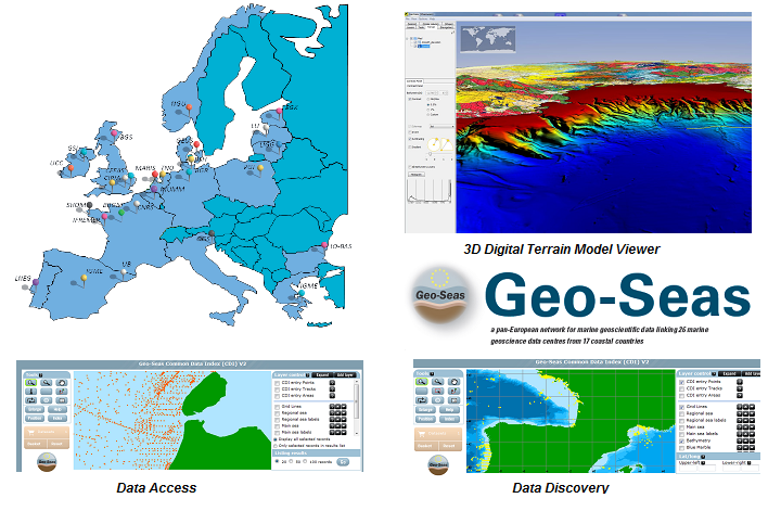
Geo-Seas European Project
Geo-Seas is Europe-wide infrastructure for managing geological and geophysical marine and ocean data for hydrographic purposes on sites which are of interest to maritime navigation. The current description is limited to making bathymetric data available within the context of the project.
Simple
- Title
-
Geo-Seas European Project
- Date (Creation)
- 2008-01-01T00:00:00
- Citation identifier
- FR-DCSMM-PDS-BD_Geo-Seas
- Presentation form
- Digital profile
- Abstract
-
Geo-Seas is Europe-wide infrastructure for managing geological and geophysical marine and ocean data for hydrographic purposes on sites which are of interest to maritime navigation. The current description is limited to making bathymetric data available within the context of the project.
- Purpose
-
Les séries temporelles de courantométrie archivées au SHOM ont été collectées soit par les groupes hydro-océanographiques soit par des organismes extérieurs ou diverses équipes scientifiques. Elles constituent la source essentielle des informations relatives aux courants de marée figurant sur les cartes marines et les ouvrages nautiques (atlas de courant de marée, instructions nautiques, etc.). Ces données sont également utilisées pour la validation des modèles numériques de courant et la réalisation des prestations spécifiques (expertise, soutien aux forces, soutien aux politiques publiques maritimes).
Toutes les mesures issues de mouillages (courantomètres au point fixe, courantomètres doppler ponctuels et profileurs) doivent être archivées dans une base pérenne.
L’objectif de la BD Courants est de disposer d’un ensemble d’outils qui permettra d’archiver, de visualiser, de qualifier et d’exploiter les données de courants au point fixe, d’avoir une meilleure traçabilité et de rendre la consultation de données disponibles et leur mise à disposition aisées pour les utilisateurs de toute nature au SHOM.
L’infrastructure est amenée à se développer dans les prochaines années à travers notamment l’intégration de nouveaux partenaires et l’amélioration et l’extension des outils et services qu’elle propose.
Les objectifs du projet suivent les directives européennes : ils sont alignés avec d’autres programmes cadres européens que sont EMODnet et INSPIRE.
- Credit
-
Data producers : NERC-BGS (United Kingdom), NERC-BODC (United Kingdom), NERC-NOCS (United Kingdom), MARIS (Netherlands), IFREMER (France), BRGM (France), TNO (Netherlands), BSH (Germany), IGME (Spain), LNEG (Portugal), IGME (Greece), GSI (Ireland), BGR (Germany), OGS (Italy), GEUS (Denmark), NGU (Norway), PGI (Poland), EGK (Estonia), NRC- IGG (Lithuania), IO-BAS (Bulgaria), NOA (Greece), CIRIA (United Kingdom), MUMM (Belgium), UB (Spain), UCC (Ireland), EU- Consult (Netherlands), CNRS (France), SHOM (France), CEFAS (United Kingdom), and LU (Latvia)
- Status
- On going
- Point of contact
-
Organisation name Individual name Electronic mail address Role SHOM
MORVAN Gaël
Local service desk
- Maintenance and update frequency
- Not planned
- Maintenance note
-
Network Duration: perennial Network
- Theme
-
-
SeaDataNet
-
EMODnet
-
Marine Geosciences Geology
-
Geophysics
-
Bathymetry
-
Hydrography
-
Seismic
-
Nature funds
-
Marine habitats
-
Cartography
-
Seabed
-
MNT
-
DTM
-
-
GEMET - INSPIRE themes, version 1.0
-
-
Environmental monitoring facilities
-
-
Sous-regions marines
-
-
National
-
-
DCSMM : Type d'espace concerné
-
-
Pas d'espace particulier concerné
-
-
DCSMM : Descripteurs
-
-
D7: Hydrographical Conditions
-
-
DCSMM : Méthodes de recueil des données
-
-
Observation par point
-
Observation par transect
-
-
Thèmes Sextant
-
-
/Physical Environment/Geology/Seabed Nature
-
- Access constraints
- Other restrictions
- Other legal constraints
-
Restricted access
The access to the data is done by means of requests on the portal. According to the use aimed by the organization carrying out a request on the Geo-Seas portal, the data can be distributed freely or be the object of a licence of paying use (restricted).
- Use limitation
-
Pricing Methods: the fee is equal to the cost of making the data available.
- Spatial representation type
- Vector
- Denominator
- 500000
- Language
- Français
- Character set
- UTF8
- Topic category
-
- Oceans
))
- Supplemental Information
-
Prime Contractor :
European Commission – Cordis : Framework 7 Research Infrastructures programme (FP7) 2008 (Geo-Seas 1) – Jan 2013
European Commission – Cordis : Framework 7 Research Infrastructures programme (FP7) Début 2014 (Geo-Seas 2) - 2017
Contracting Authorities :
NERC-British Geological Survey (UK) 2008 - Jan 2013 Société MARIS (Netherlands) 2008- Jan 2013
Backer(s) :
European Commission – Cordis : Framework 7 Research Infrastructures programme (FP7) 2008 (Geo-Seas 1) – Jan 2013
Commission européenne – Cordis : Framework 7 Research Infrastructures programme (FP7) Début 2014 (Geo-Seas 2) - 2017 SHOM
- Reference system identifier
- EPSG / WGS 84 (EPSG:4326) / 7.9
- Topology level
- Geometry only
- Geometric object type
- Complex
- Geometric object count
- 0
- OnLine resource
-
Protocol Linkage Name WWW:LINK
http://www.geo-seas.eu/ Le portail Geo-Seas
- Hierarchy level
- Dataset
Conformance result
- Title
-
Inspire specifications
- Date (Creation)
- 2012-01-16
- Explanation
-
Non assessed
- Pass
- Statement
-
2008 : Creation of the GEO-SEAS 1project
1 May 2009 : Launch of GEO-SEAS 1 31 January 2013 : Completion of GEO-SEAS 1
Followed by a new call for tender for GEO-SEAS 2 in the first trimester of 2013 (duration depends on funding from the European Commission).
Number of observation or measurement points : over 6 000 lots of bathymetric data from the SHOM.
Public data acquired in the context of research or public service programmes made available voluntarily.
Metadata and data formats, and distribution formats are agreed within the context of the project and are implemented by the data centres. Geo-Seas has adopted and adapted SeaDataNet tools and standards. The provider is responsible for its validity. At the SHOM, validation procedures are based on internal and OHI standards.
- Acquisition: SHOM standards based on OHI standards (S-44).
- Distribution: Standards defined within the context of the project for the data and metadata
XML format CDI provision on the Geo-Seas portal. Data stored in the database and distributed in ODV format.
- Description
-
Data type : Physical Oceanography Hydrography
Precision on the data type : Lots of bathymetric probes or bathymetric digital terrain models
Measured or observed parameters : : Sea depths
Parameters resolution : Variable depending on the period and the acquisition system in place.
Update frequency : Variable depending on the characteristics of the location.
Observation frequency : Variable depending on the characteristics of the location.
- Description
-
Sampling method :
Spatial, Geometric
- Description
-
Device associated : EMODnet-Hydrography, BDBS, bathymetric DTM
Metadata
- File identifier
- ed371690-f27a-4c25-b74e-178fef13737b
- Metadata language
- Français
- Other language
-
Language Character encoding English
- Character set
- UTF8
- Hierarchy level
- Series
- Date stamp
- 2024-04-08T14:24:20.795Z
- Metadata standard name
-
ISO 19115:2003/19139 - SEXTANT
- Metadata standard version
-
1.0
- Metadata author
-
Organisation name Individual name Electronic mail address Role Sextant
Local service desk
accessData
Overviews
)))