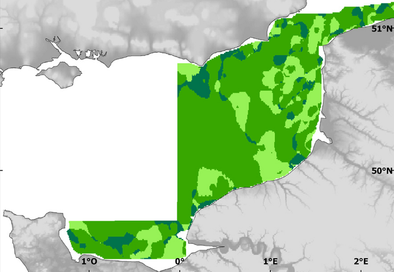
Species and habitats - Differences between the sedimentary cover of the 1971-1976 period and the sedimentary cover of the 1998-2007 period.
Granulometric characteristics were determined for each station sampled during different historical surveys.
Simple
- Title
-
Species and habitats - Differences between the sedimentary cover of the 1971-1976 period and the sedimentary cover of the 1998-2007 period.
- Alternate title
-
allsurveys_environment_geostatP
- Alternate title
-
CHARM_SEDIM_DIFF_R
- Date (Publication)
- 2009-12-31T00:00:00
- Citation identifier
- CHARM_SEDIM_DIFF_R
- Presentation form
- Digital map
- Other citation details
-
Source CHARM Consortium
- Abstract
-
Granulometric characteristics were determined for each station sampled during different historical surveys.
- Credit
-
Station Marine de Wimereux, Université des Sciences et Technologies de Lille
- Credit
-
CHARM Consortium
- Status
- Completed
- Point of contact
-
Organisation name Individual name Electronic mail address Role Station Marine de Wimereux, Université des Sciences et Technologies de Lille
Jean-Marie Dewarumez
Local service desk CHARM Consortium
CHARM Consortium
Production center
- Maintenance and update frequency
- As needed
-
Thèmes Sextant
-
-
/Physical Environment/Geology/Mineral Resources
-
- Theme
-
-
Environment data set
-
CHARM
-
-
GEMET - INSPIRE themes, version 1.0
-
-
Habitats et biotopes
-
- Use limitation
-
research-only
- Access constraints
- License
- Other legal constraints
-
Has to be cited this way in maps : "Source CHARM Consortium"
- Other legal constraints
-
Has to be cited this way in bibliography : "Carpentier A, Martin CS, Vaz S (Eds.), 2009. Channel Habitat Atlas for marine Resource Management, final report / Atlas des habitats des ressources marines de la Manche orientale, rapport final (CHARM phase II). INTERREG 3a Programme, IFREMER, Boulogne-sur-mer, France. 626 pp. & CD-rom"
- Spatial representation type
- Grid
- Denominator
- 1000
- Language
- Français
- Language
- English
- Character set
- UTF8
- Topic category
-
- Imagery base maps earth cover
- Oceans
- Geoscientific information
- Environment description
-
Microsoft Windows XP ; ESRI ArcGIS 9.x
- Geographic identifier
- Eastern English Channel
))
- Begin date
- 1971-01-01
- End date
- 2008-12-31
- Reference system identifier
- 4326
Distributor
- Distributor contact
-
Organisation name Individual name Electronic mail address Role Ifremer - Centre de Brest
Dissemination Unit
- Distributor format
-
Name Version
- OnLine resource
-
Protocol Linkage Name OGC:WMS
https://sextant.ifremer.fr/services/wms/wms_charm CHARM_SEDIM_DIFF_R
WWW:LINK
http://www.ifremer.fr/charm/ COPYFILE
Difference
- Hierarchy level
- Dataset
- Statement
-
For this calculation, sedimentary cover maps of the 1971-1976 and 1998-2007 were used.
- Description
-
The calculation consists to subtract the recent sedimentary cover raster to the historical sedimentary cover raster. This new raster highlights areas of same type of sediment, areas of finer sediment and areas of coarser sediment.
Metadata
- File identifier
- edacc620-0141-11e0-abec-005056987263
- Metadata language
- English
- Character set
- UTF8
- Hierarchy level
- Dataset
- Date stamp
- 2024-04-05T09:31:39.105Z
- Metadata standard name
-
ISO 19115:2003/19139 - SEXTANT
- Metadata standard version
-
1.0
- Metadata author
-
Organisation name Individual name Electronic mail address Role Ifremer
Sandrine Vaz
Local service desk
accessData
Overviews
)))