MEDSEA_CH2_Product_2 / Med conservation areas and depth zones
Shape file with the layers containing the information as in Product CH2-1 and depth/biological zones. Fisheries Restricted Areas with specifics on the prohibitions and the type of closure.
Simple
Identification info
- Date (Creation)
- 2016-12-06T00:00:00
- Date (Revision)
- 2016-12-06T00:00:00
- Citation identifier
- DOI:10.12770/f11a2f9c-e070-44ae-981f-fb5c70f6bda2
- Issue identification
-
MEDSEA D3.3.5
- Purpose
-
Med conservation areas, biological zones, fisheries restricted areas.
- Credit
-
EMODnet Medsea Checkpoint
- Point of contact
-
Organisation Individual Electronic mail address ORCID Role HCMR
Point of contact EMODnet Medsea Checkpoint
Publisher HCMR
Sofia Reizopoulou
Author HCMR
Chara Kyriakidou
Author HCMR
Isidora Katara
Author HCMR
Marianna Giannoulaki
Author
- Spatial representation type
- Vector
- Topic category
-
- Oceans
Extent
))
Extent
- Time period
- 1933-01-01T00:00:00 2014-12-31T00:00:00
Vertical element
- Minimum value
- 0
- Maximum value
- 5200
- Used by challenges
-
-
MedSea - CH02 - Marine Protected Areas
-
- Processing level of characteristics
-
-
High level analyzed
-
- Production mode
-
-
Delayed
-
- GEMET - INSPIRE themes, version 1.0
-
-
Protected sites
-
- Theme
-
-
Marine Protected Areas
-
MPAs
-
Mediterranean
-
Conservation areas
-
Resource constraints
- Use constraints
- Restricted
Associated resource
- Association Type
- Cross reference
- Initiative Type
- specification
- Metadata Reference
Associated resource
- Association Type
- Cross reference
- Initiative Type
- upstreamData
Associated resource
- Association Type
- Cross reference
- Initiative Type
- upstreamData
Associated resource
- Association Type
- Cross reference
- Initiative Type
- upstreamData
- Language
- English
- Character encoding
- UTF8
Distribution Information
- Distribution format
-
-
ESRI Shapefile
-
- OnLine resource
-
DOI of the product
DOI of the product
- OnLine resource
-
CH2_product_2
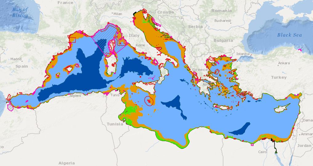
Product visualization
MEDSEA_CH2_Product_2 / Med conservation areas and depth zones - Layers containing information for Marine protected areas and depth/biological zones. Fisheries Restricted Areas with specifics on the prohibitions and the type of closure.
- Begin date
- 1933-01-01T00:00:00
- End date
- 2014-12-31T00:00:00 After
Vertical element
- Minimum value
- 0
- Maximum value
- 5200
Reference System Information
- Reference system identifier
- http://www.opengis.net/def/crs/EPSG/0/4326
- Reference system type
- Geodetic Geographic 2D
Metadata
- Metadata identifier
- urn:uuid/f11a2f9c-e070-44ae-981f-fb5c70f6bda2
- Language
- English
- Character encoding
- UTF8
Type of resource
- Resource type
- Dataset
- Metadata linkage
-
http://localhost:8080/geonetwork/srv/eng//metadata/286d8887-58a5-4562-a0b9-a69b78fced76
- Metadata linkage
-
http://localhost:8080/geonetwork/srv/eng//metadata/47dea01f-5b6a-48d7-990a-606a6001cbef
- Metadata linkage
-
https://sextant.ifremer.fr/geonetwork/srv/eng//metadata/f11a2f9c-e070-44ae-981f-fb5c70f6bda2
- Metadata linkage
-
https://sextant.ifremer.fr/geonetwork/srv/fre//metadata/f11a2f9c-e070-44ae-981f-fb5c70f6bda2
- Date info (Revision)
- 2017-08-24T12:29:44Z
- Date info (Creation)
- 2005-03-31T19:13:30
Metadata standard
- Title
-
ISO 19115-3 - Emodnet Checkpoint - Targeted Data Product
accessData
Overviews
Spatial extent
)))