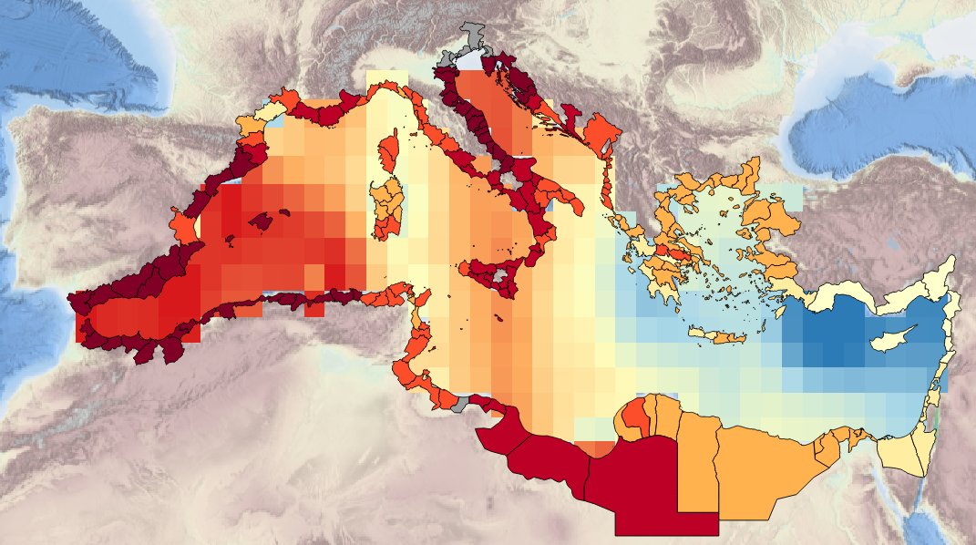
MEDSEA_CH4_Product_1 / Spatial layers of Sea surface temperature trend from observations (HadISST dataset) over periods of 10 (2003 – 2012), 50 (1963-2012) and 100 (1913-2012) years. Basin maps and NUTS3 region are considered
Description of the spatial layers atributes of sea surface temperature trend for the last 10, 50 and 100 years for the Mediterranean basin and for each NUTS3 region along the coast.
Simple
Identification info
- Date (Creation)
- 2016-12-15T00:00:00
- Citation identifier
- DOI:10.12770/f25961c9-ae73-4046-9f57-09f323f98782
- Issue identification
-
MEDSEA D5.3.5
- Purpose
-
Production of spatial layers of sea surface temperature trend for the last 10, 50 and 100 years.
- Credit
-
EMODnet Medsea Checkpoint
- Point of contact
-
Organisation Individual Electronic mail address ORCID Role CMCC, Centro Euro-Mediterraneo sui Caimbiamento Climatici
Point of contact EMODnet Medsea Checkpoint
Publisher CMCC
Ritta Lecci
Author
- Spatial representation type
- Grid
- Topic category
-
- Oceans
Extent
))
Extent
- Time period
- 1913-01-01 2012-12-31
Vertical element
- Minimum value
- 0
- Maximum value
- 0
- Used by challenges
-
-
MedSea - CH04 - Climate and Coastal Protection
-
- Processing level of characteristics
-
-
High level analyzed
-
- Production mode
-
-
Delayed
-
- GEMET - INSPIRE themes, version 1.0
-
-
Oceanographic geographical features
-
- Theme
-
-
Sea surface
-
Temperature trend
-
HadISST
-
Resource constraints
- Use limitation
-
Consult Medsea_Checkpoint fitness for purpose documents
- Use constraints
Associated resource
- Association Type
- Cross reference
- Initiative Type
- specification
Associated resource
- Association Type
- Cross reference
- Initiative Type
- upstreamData
- Language
- English
- Character encoding
- UTF8
Distribution Information
- Distribution format
-
-
ESRI Shapefile
-
- OnLine resource
-
DOI of the product
DOI of the product
- OnLine resource
-
CH4_product_1
Product visualization
MEDSEA_CH4_Product_1 / Spatial layers of Sea surface temperature trend from observations (HadISST dataset) over periods of 10 (2003 – 2012), 50 (1963-2012) and 100 (1913-2012) years. Basin maps and NUTS3 region are considered - Basin Sea Surface Temperature Trend for the Last 10 yrs
- Begin date
- 2003-01-01
- End date
- 2012-12-31
Vertical element
- Minimum value
- 0
- Maximum value
- 0
MEDSEA_CH4_Product_1 / Spatial layers of Sea surface temperature trend from observations (HadISST dataset) over periods of 10 (2003 – 2012), 50 (1963-2012) and 100 (1913-2012) years. Basin maps and NUTS3 region are considered - Basin Sea Surface Temperature Trend for the Last 50 yrs
- Begin date
- 19163-01-01
- End date
- 2012-12-31
Vertical element
- Minimum value
- 0
- Maximum value
- 0
MEDSEA_CH4_Product_1 / Spatial layers of Sea surface temperature trend from observations (HadISST dataset) over periods of 10 (2003 – 2012), 50 (1963-2012) and 100 (1913-2012) years. Basin maps and NUTS3 region are considered - Basin Sea Surface Temperature Trend for the Last 100 yrs
- Begin date
- 1913-01-01
- End date
- 2012-12-31
Vertical element
- Minimum value
- 0
- Maximum value
- 0
MEDSEA_CH4_Product_1 / Spatial layers of Sea surface temperature trend from observations (HadISST dataset) over periods of 10 (2003 – 2012), 50 (1963-2012) and 100 (1913-2012) years. Basin maps and NUTS3 region are considered - NUTS3 Regions Spatial Layer Sea Surface Temperature Trend for the Last 10 yrs
- Begin date
- 2003-01-01
- End date
- 2012-12-31
Vertical element
- Minimum value
- 0
- Maximum value
- 0
MEDSEA_CH4_Product_1 / Spatial layers of Sea surface temperature trend from observations (HadISST dataset) over periods of 10 (2003 – 2012), 50 (1963-2012) and 100 (1913-2012) years. Basin maps and NUTS3 region are considered - NUTS3 Regions Spatial Layer of Sea Surface Temperature Trend for the Last 50 yrs
- Begin date
- 1963-01-01
- End date
- 2012-12-31
Vertical element
- Minimum value
- 0
- Maximum value
- 0
MEDSEA_CH4_Product_1 / Spatial layers of Sea surface temperature trend from observations (HadISST dataset) over periods of 10 (2003 – 2012), 50 (1963-2012) and 100 (1913-2012) years. Basin maps and NUTS3 region are considered - NUTS3 Regions Spatial Layer of Sea Surface Temperature Trend for the Last 100 yrs
- Begin date
- 1913-01-01
- End date
- 2012-12-31
Vertical element
- Minimum value
- 0
- Maximum value
- 0
Metadata
- Metadata identifier
- urn:uuid/f25961c9-ae73-4046-9f57-09f323f98782
- Language
- English
- Character encoding
- UTF8
Type of resource
- Resource type
- Dataset
- Metadata linkage
-
http://localhost:8080/geonetwork/srv/eng//metadata/286d8887-58a5-4562-a0b9-a69b78fced76
- Metadata linkage
-
http://localhost:8080/geonetwork/srv/eng//metadata/47dea01f-5b6a-48d7-990a-606a6001cbef
- Metadata linkage
-
https://sextant.ifremer.fr/geonetwork/srv/eng//metadata/f25961c9-ae73-4046-9f57-09f323f98782
- Metadata linkage
-
https://sextant.ifremer.fr/geonetwork/srv/fre//metadata/f25961c9-ae73-4046-9f57-09f323f98782
- Date info (Revision)
- 2017-08-24T12:30:08Z
- Date info (Creation)
- 2005-03-31T19:13:30
Metadata standard
- Title
-
ISO 19115-3 - Emodnet Checkpoint - Targeted Data Product
accessData
Overviews
Spatial extent
)))