MEDSEA_CH2_Product_4 / Qualitative analysis of connectivity between MPAs
In order to assess the connectivity oceanographic data will be used. A shape map will be created combining data on MPAs adequacy and distribution of MPAs and temperature, currents seasonal GIS layers (The temperature and currents are INGV climatological products made available to CH2.
Simple
Identification info
- Date (Creation)
- 2016-11-22T00:00:00
- Date (Revision)
- 2016-11-22T00:00:00
- Citation identifier
- DOI:10.12770/f4d3dd30-633b-4a49-9c09-1e1243f36763
- Issue identification
-
MEDSEA D3.3.5
- Purpose
-
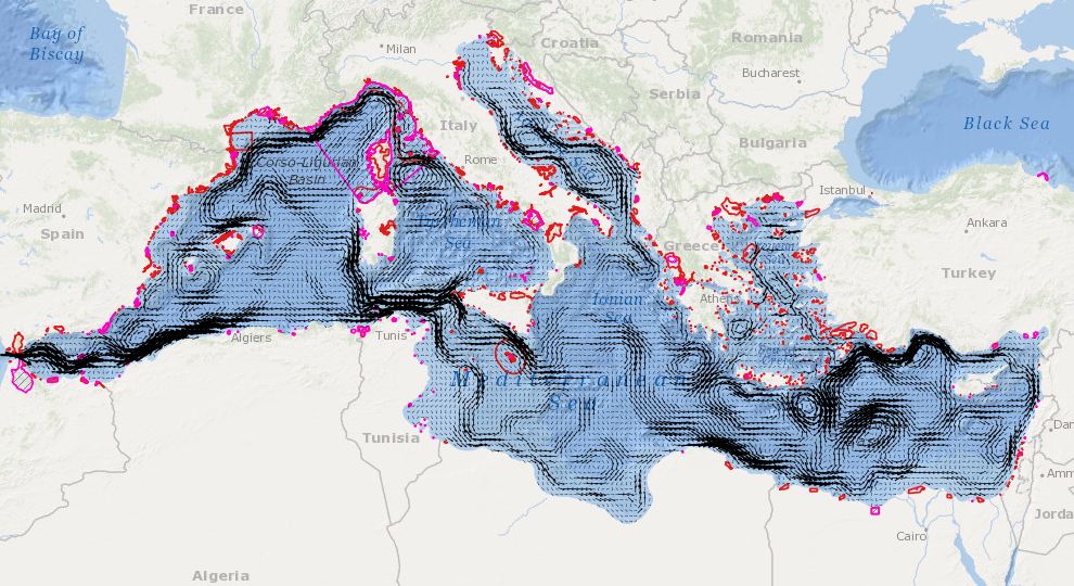
Qualitative analysis of connectivity between MPAs. Combination of MPA, temperature, currents seasonal GIS layers
- Credit
-
EMODnet Medsea Checkpoint
- Point of contact
-
Organisation Individual Electronic mail address ORCID Role HCMR
Point of contact EMODnet Medsea Checkpoint
Publisher HCMR
Sofia Reizopoulou
Author HCMR
Chara Kyriakidou
Author INGV
Simona Simoncelli
Author INGV
Nadia Pinardi
Author
- Spatial representation type
- Grid
- Topic category
-
- Oceans
Extent
))
Extent
- Time period
- 1987-01-01T00:00:00 2013-01-01T00:00:00
Vertical element
- Minimum value
- 0
- Maximum value
- 200
- Used by challenges
-
-
MedSea - CH02 - Marine Protected Areas
-
- Processing level of characteristics
-
-
High level analyzed
-
- Production mode
-
-
Delayed
-
- GEMET - INSPIRE themes, version 1.0
-
-
Oceanographic geographical features
-
- Theme
-
-
Marine Protected Areas
-
MPAs
-
Temperature
-
Currents
-
Seasonal
-
Mediterranean
-
Resource constraints
- Use constraints
Associated resource
- Association Type
- Cross reference
- Initiative Type
- specification
Associated resource
- Association Type
- Cross reference
- Initiative Type
- upstreamData
Associated resource
- Association Type
- Cross reference
- Initiative Type
- upstreamData
Associated resource
- Association Type
- Cross reference
- Initiative Type
- upstreamData
- Language
- English
- Character encoding
- UTF8
Distribution Information
- Distribution format
-
-
ESRI Shapefile
-
- OnLine resource
-
DOI of the product
DOI of the product
- OnLine resource
-
CH2_product_4
Product visualization
MEDSEA_CH2_Product_4 / Qualitative analysis of connectivity between MPAs - Qualitative analysis of connectivity between MPAs. Combination of MPA, seasonal surface temperature and currents
- Begin date
- 1987-01-01T00:00:00
- End date
- 2013-12-31T00:00:00 Now
Vertical element
- Minimum value
- 0
- Maximum value
- 0
MEDSEA_CH2_Product_4 / Qualitative analysis of connectivity between MPAs - Qualitative analysis of connectivity between MPAs. Combination of MPA, seasonal surface temperature and currents
- Begin date
- 1987-01-01T00:00:00
- End date
- 2013-12-31T00:00:00 Now
Vertical element
- Minimum value
- 0
- Maximum value
- 200
Reference System Information
- Reference system identifier
- http://www.opengis.net/def/crs/EPSG/0/4326
- Reference system type
- Geodetic Geographic 2D
Metadata
- Metadata identifier
- urn:uuid/f4d3dd30-633b-4a49-9c09-1e1243f36763
- Language
- English
- Character encoding
- UTF8
Type of resource
- Resource type
- Dataset
- Metadata linkage
-
http://localhost:8080/geonetwork/srv/eng//metadata/286d8887-58a5-4562-a0b9-a69b78fced76
- Metadata linkage
-
http://localhost:8080/geonetwork/srv/eng//metadata/47dea01f-5b6a-48d7-990a-606a6001cbef
- Metadata linkage
-
https://sextant.ifremer.fr/geonetwork/srv/eng//metadata/f4d3dd30-633b-4a49-9c09-1e1243f36763
- Metadata linkage
-
https://sextant.ifremer.fr/geonetwork/srv/fre//metadata/f4d3dd30-633b-4a49-9c09-1e1243f36763
- Date info (Revision)
- 2017-08-24T12:29:57Z
- Date info (Creation)
- 2005-03-31T19:13:30
Metadata standard
- Title
-
ISO 19115-3 - Emodnet Checkpoint - Targeted Data Product
accessData
Overviews
Spatial extent
)))