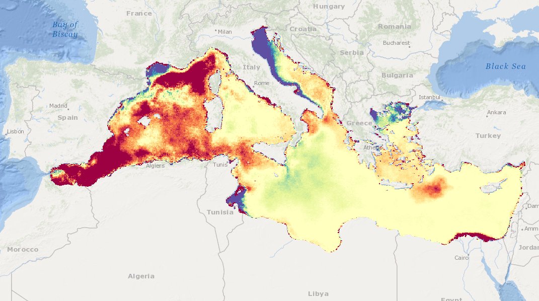
MEDSEA_CH6_Product_2 / Map of Chlorophyll concentration trend over the Mediterranean Sea, relative to the period 1998-2009, expressed as percent of variation respect to the climatological field
Map of Chlorophyll trends (UNITS: mg/m3/year) from L4 satellite ocean color data FOR THE PAST 10 YEARS (2005-2014)
Simple
Identification info
- Date (Creation)
- 2016-12-22T00:00:00
- Date (Revision)
- 2016-12-22T00:00:00
- Citation identifier
- DOI:10.12770/faa5f13e-6840-4447-97ed-d37567b50922
- Purpose
-
Change in eutrophication over past ten years (i.e. where eutrophication has reduced and where it has increased)
- Credit
-
EMODnet Medsea Checkpoint
- Point of contact
-
Organisation Individual Electronic mail address ORCID Role CNR-ISAC
Point of contact EMODnet Medsea Checkpoint
Publisher ISAC-CNR, Oceans.cat
Author ISAC-CNR, Oceans.cat
Author
- Spatial representation type
- Grid
- Topic category
-
- Oceans
Extent
))
Extent
- Time period
- 2005-01-01T00:00:00 2014-12-31T00:00:00
Vertical element
- Minimum value
- 0
- Maximum value
- 10
- Used by challenges
-
-
MedSea - CH06 - Marine Environment
-
- Processing level of characteristics
-
-
High level analyzed
-
- Production mode
-
-
Delayed
-
- GEMET - INSPIRE themes, version 1.0
-
-
Oceanographic geographical features
-
- Theme
-
-
satellite chlorophyll
-
time series
-
maps
-
trends
-
Mediterranean Sea
-
Resource constraints
- Use limitation
-
freely available
- Use constraints
Associated resource
- Association Type
- Cross reference
- Initiative Type
- specification
- Language
- English
- Character encoding
- UTF8
Distribution Information
- Distribution format
-
-
ESRI Shapefile
-
NetCDF
-
- OnLine resource
-
DOI of the product
DOI of the product
- OnLine resource
-
CH6_product_2
Product visualization
MEDSEA_CH6_Product_2 / Map of Chlorophyll concentration trend over the Mediterranean Sea, relative to the period 1998-2009, expressed as percent of variation respect to the climatological field - Map of Chlorophyll concentration trend over the Mediterranean Sea, relative to the period 1998-2009, expressed as percent of variation respect to the climatological field.
- Begin date
- 2005-01-01T00:00:00
- End date
- 2014-12-31T00:00:00
Vertical element
- Minimum value
- 0
- Maximum value
- 10
Metadata
- Metadata identifier
- urn:uuid/faa5f13e-6840-4447-97ed-d37567b50922
- Language
- English
- Character encoding
- UTF8
Type of resource
- Resource type
- Dataset
- Metadata linkage
-
http://localhost:8080/geonetwork/srv/eng//metadata/286d8887-58a5-4562-a0b9-a69b78fced76
- Metadata linkage
-
http://localhost:8080/geonetwork/srv/eng//metadata/47dea01f-5b6a-48d7-990a-606a6001cbef
- Metadata linkage
-
https://sextant.ifremer.fr/geonetwork/srv/eng//metadata/faa5f13e-6840-4447-97ed-d37567b50922
- Metadata linkage
-
https://sextant.ifremer.fr/geonetwork/srv/fre//metadata/faa5f13e-6840-4447-97ed-d37567b50922
- Date info (Revision)
- 2017-08-24T12:29:52Z
- Date info (Creation)
- 2005-03-31T19:13:30
Metadata standard
- Title
-
ISO 19115-3 - Emodnet Checkpoint - Targeted Data Product
accessData
Overviews
Spatial extent
)))