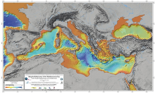
Morpho-Bathymetry of the Mediterranean Sea
The systematic swath bathymetric mapping of the Mediterranean Sea started in the mid-nineties. This mapping has considerably modified our understanding of the morphology of the Mediterreanean Sea and of the various active geological processes (sedimentary, tectonic, volcanic, bio-geochemical processes) which participate to the seafloor morphology.
Simple
- Title
-
Morpho-Bathymetry of the Mediterranean Sea
- Date (Creation)
- 2015-07-22
- Abstract
-
The systematic swath bathymetric mapping of the Mediterranean Sea started in the mid-nineties. This mapping has considerably modified our understanding of the morphology of the Mediterreanean Sea and of the various active geological processes (sedimentary, tectonic, volcanic, bio-geochemical processes) which participate to the seafloor morphology.
- Credit
-
MISTRALS
- Point of contact
-
Organisation name Individual name Electronic mail address Role Université de Brest
Campistron Laeticia
Author
-
Centre de données ODATIS
-
-
CDS-OMP
-
-
Thèmatiques ODATIS
-
-
Added-value products
-
-
Type de jeux de donnée ODATIS
-
-
Aggregate data
-
- Keywords
-
-
ODATIS aggregation parameters and Essential Variable names
-
-
Bathymetry
-
- Use limitation
-
Data users must comply with the MISTRALS Data Policy, including contact to the principal investigator to agree on either co-authorship or aknowledgement
- Access constraints
- Other restrictions
- Use constraints
- License
- Other legal constraints
-
The following reference map should be cited in any publication: Brosolo,L., Mascle,J., Loubrieu,B., 2012, Morphobathymetric Map of the Mediterranean Sea, publication CCGM/CGMW, UNESCO, Paris. © CCGM-CGMW 2012 - ISBN 978-2-917310-12-0. The compilation has been funded by the MISTRALS program and resulted from various previous DTM (Ifremer, GEBCO, SRTM 33'), from swath bathymetric data sets recorded by several laboratories and Institutes (IFREMER, SHOM, CNRS-INSU-GEOAZUR, OGS-Trieste, ISMAR-Bologna, CMCR-Hamburg...) and by Industry (BP-Egypt, ENI, OMV), and from the EMODNET and ASSEMBLAGE European projects outputs
- Spatial representation type
- Grid
- Denominator
- 50000
- Language
- Français
- Character set
- UTF8
- Topic category
-
- Oceans
))
- Distribution format
-
Name Version NetCDF
3
XYZ Ascii
- Transfer size (in MB)
- 800
- OnLine resource
-
Protocol Linkage Name WWW:LINK-1.0-http--metadata-URL
http://data.datacite.org/10.6096/MISTRALS.1341 WWW:LINK
http://mistrals.sedoo.fr/MISTRALS/?editDatsId=1341 Accès authentifié au jeu de données
OGC:WMS
https://api.sedoo.fr/sedoo-wms/wms/bathy.nc?service=WMS&version=1.3.0&request=GetCapabilities Band1
- Hierarchy level
- Dataset
- Statement
-
Brosolo,L., Mascle,J., Loubrieu,B., 2012, Morphobathymetric Map of the Mediterranean Sea, publication CCGM/CGMW, UNESCO, Paris. © CCGM-CGMW 2012 - ISBN 978-2-917310-12-0
This map results from the compilation of the following DTMs and complementary data:
- The basic DTM is the one used for the Morpho-bathymetric compilation of the Mediterranean Sea published by Loubrieu,B., Mascle,J. and Medimap group, (2007), « Morpho-bathymetry of the Mediterranean Sea », CIESM/Ifremer special publication.
This compilation resulted from various DTMs from swath bathymetric data sets recorded between 1995-2007 by several European oceanographic laboratories and Institutes (see: http://www.ciesm.org/).
- This DTM has been completed by unpublished swath bathymetry data from IFREMER, SHOM, GEOAZUR, OGS-Trieste, ISMAR-Bologna, CMCR- Hamburg and, off Egypt, by a few 3D seismic data first arrivals from Industry (BP-Egypt, ENI, OMV).
A few complementary data have been downloaded from the EMODNET European project portal ((www.emodnet-hydrography.eu/)
- For the Gulf of Cadiz the compilation has benefited from a DTM at 500 m from various swath data published by Zitellini, N., Gracia, E., et a., (2009), « Bathymetry of the Gulf of Cadiz, North-East Atlantic: the Swim Multibeam compilation », Earth and Planetary Sciences Letters, 280: 15-50.doi: 10.1016/j.epsl.2008.12.005.
- For the Black Sea, the swath bathymetric data were obtained during the European project ASSEMBLAGE.
- For the Bay of Biscay a DTM at 1000m, from Sibuet, J.C., Loubrieu, B., & al. (2004) « Carte bathymétrique de l’Atlantique nord-est et du Golfe de Gascogne: implications cinématiques », Bull. Soc. Géol. Fr., has been used.
- For areas not yet mapped in details (or whose data are not yet available) in the Mediterranean Sea, and in the Black Sea a DTM, at 1500m, from the GEBCO atlas has been used to complete the map (General Bathymetric Chart of the Oceans; http://www.gebco.net/data_and_products/gebco_digital_atlas/)
- On land the topography is extracted from SRTM 33’’ (Shuttle Radar Topography Mission, NASA); DTM at 90m.
Conformance result
- Title
-
Inspire specifications
- Date (Creation)
- 2012-01-16
- Explanation
-
Non évalué
Metadata
- File identifier
- fcb72f2c-0033-4706-9ed7-ad36ffaf1024
- Metadata language
- English
- Other language
-
Language Character encoding French UTF8
- Character set
- UTF8
- Hierarchy level
- Dataset
- Date stamp
- 2024-10-28T14:57:25.193739Z
- Metadata standard name
-
ISO 19115:2003/19139 - SEXTANT
- Metadata standard version
-
1.0
accessData
Overviews

)))