Labeled SAR imagery dataset of ten geophysical phenomena from Sentinel-1 wave mode (TenGeoP-SARwv)
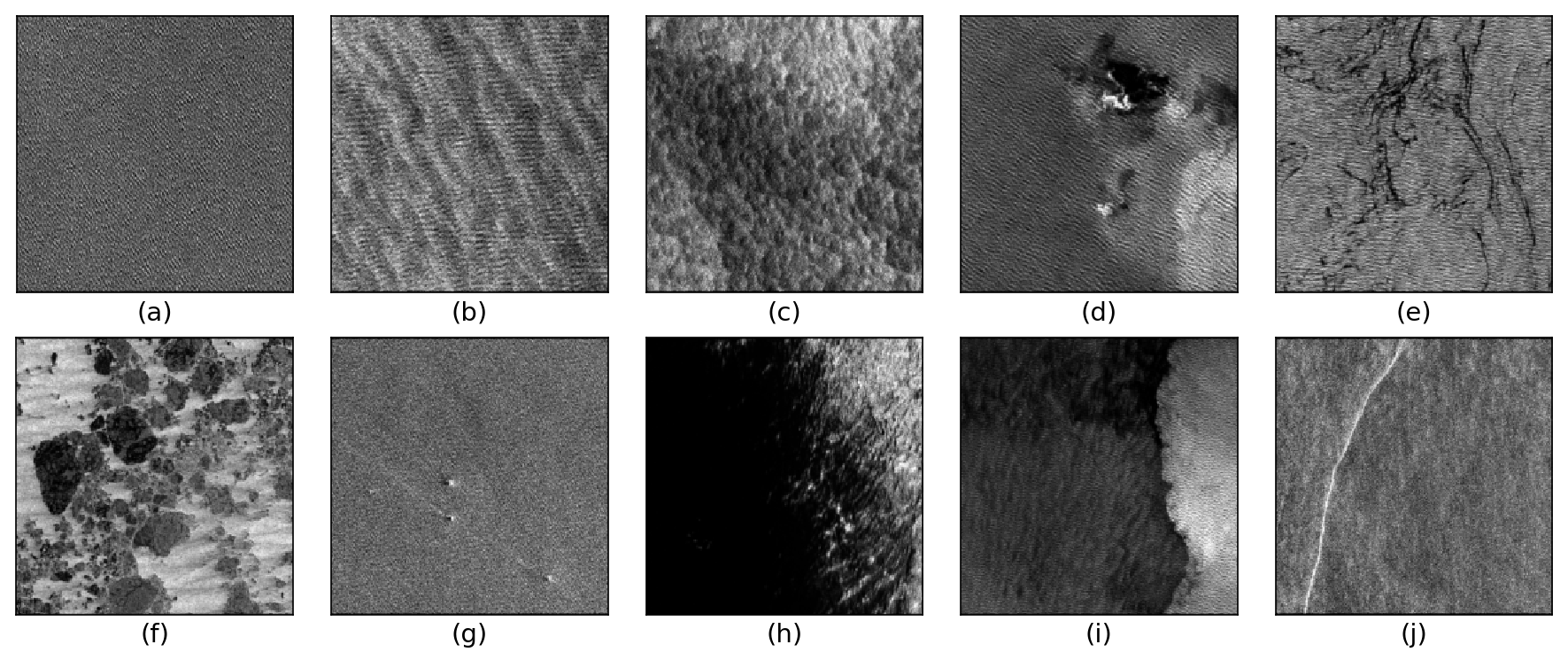
The TenGeoP-SARwv dataset is established based on the acquisitions of Sentinel-1A wave mode (WV) in VV polarization. This dataset consists of more than 37,000 SAR vignettes divided into ten defined geophysical categories, including both oceanic and meteorologic features. These images cover the entire open ocean and are manually selected from Sentinel-1A WV acquisitions in 2016. For each image, only one prevalent geophysical phenomena with its prescribed signature and texture is selected for labeling. The SAR images are processed into a quick-look image provided in the formats of PNG and GeoTIFF as well as the associated labels. They are convenient for both visual inspection and machine-learning-based methods exploitation. The proposed dataset is the first one involving different oceanic or atmospheric phenomena over the open ocean. It seeks to foster the development of strategies or approaches for massive ocean SAR image analysis. A key objective is to allow exploiting the full potential of Sentinel-1 WV SAR acquisitions, which are about 60,000 images per satellite per month and freely available. Such a dataset may be of value to a wide range of users and communities in deep learning, remote sensing, oceanography, and meteorology
Simple
- Title
-
Labeled SAR imagery dataset of ten geophysical phenomena from Sentinel-1 wave mode (TenGeoP-SARwv)
- Date (Publication)
- 2018
- Date (Revision)
- 2024-03-08
- Other citation details
-
Wang Chen, Mouche Alexis, Tandeo Pierre, Stopa Justin, Longépé Nicolas, Erhard Guillaume, Foster Ralph, Vandemark Douglas, Chapron Bertrand (2018). Labeled SAR imagery dataset of ten geophysical phenomena from Sentinel-1 wave mode (TenGeoP-SARwv). SEANOE. https://doi.org/10.17882/56796
In addition to properly cite this dataset, it would be appreciated that the following work(s) be cited too, when using this dataset in a publication :
Wang Chen, Mouche Alexis, Tandeo Pierre, Stopa Justin, Longépé Nicolas, Erhard Guillaume, Foster Ralph C., Vandemark Douglas, Chapron Bertrand (2019). A labelled ocean SAR imagery dataset of ten geophysical phenomena from Sentinel‐1 wave mode. Geoscience Data Journal, 6(2), 105-115. https://doi.org/10.1002/gdj3.73
- Abstract
-
The TenGeoP-SARwv dataset is established based on the acquisitions of Sentinel-1A wave mode (WV) in VV polarization. This dataset consists of more than 37,000 SAR vignettes divided into ten defined geophysical categories, including both oceanic and meteorologic features. These images cover the entire open ocean and are manually selected from Sentinel-1A WV acquisitions in 2016. For each image, only one prevalent geophysical phenomena with its prescribed signature and texture is selected for labeling. The SAR images are processed into a quick-look image provided in the formats of PNG and GeoTIFF as well as the associated labels. They are convenient for both visual inspection and machine-learning-based methods exploitation. The proposed dataset is the first one involving different oceanic or atmospheric phenomena over the open ocean. It seeks to foster the development of strategies or approaches for massive ocean SAR image analysis. A key objective is to allow exploiting the full potential of Sentinel-1 WV SAR acquisitions, which are about 60,000 images per satellite per month and freely available. Such a dataset may be of value to a wide range of users and communities in deep learning, remote sensing, oceanography, and meteorology
- Point of contact
-
Organisation name Individual name Electronic mail address Role Univ. Brest, CNRS, IRD, Ifremer, Laboratoire d'Océanographie Physique et Spatiale (LOPS), IUEM, 29280, Brest, France Institut Mines-Télécom Atlantique, UMR 6285 LabSTICC, Université Bretagne Loire, Technopôle Brest-Iroise CS 83818, 29238 Brest Cedex 3, France
WANG Chen
Author Univ. Brest, CNRS, IRD, Ifremer, Laboratoire d'Océanographie Physique et Spatiale (LOPS), IUEM, 29280, Brest, France
MOUCHE Alexis
Author Institut Mines-Télécom Atlantique, UMR 6285 LabSTICC, Université Bretagne Loire, Technopôle Brest-Iroise CS 83818, 29238 Brest Cedex 3, France
Tandeo Pierre
Author Univ. Brest, CNRS, IRD, Ifremer, Laboratoire d'Océanographie Physique et Spatiale (LOPS), IUEM, 29280, Brest, France
Stopa Justin
Author Space and Ground Segment, Collecte Localisation Satellites (CLS), Plouzané, France
Longépé Nicolas
Author Space and Ground Segment, Collecte Localisation Satellites (CLS), Plouzané, France
Erhard Guillaume
Author Applied Physics Laboratory, University of Washington, 1013 NE 40th Street, Seattle, Washington, USA
Foster Ralph
Author Ocean Processes Analysis Laboratory, University of New Hampshire, New Hampshire, USA
Vandemark Douglas
Author Univ. Brest, CNRS, IRD, Ifremer, Laboratoire d'Océanographie Physique et Spatiale (LOPS), IUEM, 29280, Brest, France
CHAPRON Bertrand
Author SEANOE
Publisher
- Theme
-
-
Synthetic aperture radar (SAR)
-
Sentinel-1 wave mode
-
SAR images
-
Geophysical phenomena
-
Classification
-
Manually labeling
-
Physical oceanography
-
Cross-discipline
-
Environment
-
- Use limitation
- CC-BY-NC-SA (Creative Commons - Attribution, No commercial usage, Sharing under the same conditions)
- Use constraints
- Other restrictions
- Title
-
A multi-tagged SAR ocean image dataset identifying atmospheric boundary layer structure in winter tradewind conditions
- Date (Publication)
- 2025
- Cited responsible party
-
Organisation name Individual name Electronic mail address Role Wiley
Publisher Wang Chen
Author Stopa Justin
Author Vandemark Doug
Author Foster Ralph
Author Ayet Alex
Author Mouche Alexis
Author Chapron Bertrand
Author Sadowski Peter
Author
- Code
- 10.1002/gdj3.282
- Association Type
- Cross reference
- Initiative Type
- Study
- Title
-
A Multichannel-Based Deep Learning Framework for Ocean SAR Scene Classification
- Date (Publication)
- 2024
- Cited responsible party
-
Organisation name Individual name Electronic mail address Role MDPI AG
Publisher Bai Chengzu
Author Zhang Shuo
Author Wang Xinning
Author Wen Jiaqiang
Author Li Chong
Author
- Code
- 10.3390/app14041489
- Association Type
- Cross reference
- Initiative Type
- Study
- Title
-
Sea Ice Extraction via Remote Sensing Imagery: Algorithms, Datasets, Applications and Challenges
- Date (Publication)
- 2024
- Cited responsible party
-
Organisation name Individual name Electronic mail address Role MDPI AG
Publisher Huang Wenjun
Author Yu Anzhu
Author Xu Qing
Author Sun Qun
Author Guo Wenyue
Author Ji Song
Author Wen Bowei
Author Qiu Chunping
Author
- Code
- 10.3390/rs16050842
- Association Type
- Cross reference
- Initiative Type
- Study
- Title
-
Backscattering Statistics of Labeled Sentinel-1 Wave Mode Imagettes for Ten Geophysical Phenomena
- Date (Publication)
- 2022
- Cited responsible party
-
Organisation name Individual name Electronic mail address Role MDPI AG
Publisher Dai Ziyue
Author Li Huimin
Author Wang Chen
Author He Yijun
Author
- Code
- 10.3390/jmse10111594
- Association Type
- Cross reference
- Initiative Type
- Study
- Title
-
Sea Surface Wind Speed Retrieval From Textures in Synthetic Aperture Radar Imagery
- Date (Publication)
- 2021
- Cited responsible party
-
Organisation name Individual name Electronic mail address Role Institute of Electrical and Electronics Engineers (IEEE)
Publisher Zhou Lizhang
Author Zheng Gang
Author Yang Jingsong
Author Li Xiaofeng
Author Zhang Bin
Author Wang He
Author Chen Peng
Author Wang Yan
Author
- Association Type
- Cross reference
- Initiative Type
- Study
- Title
-
An assessment of marine atmospheric boundary layer roll detection using Sentinel-1 SAR data
- Date (Publication)
- 2020
- Cited responsible party
-
Organisation name Individual name Electronic mail address Role Elsevier BV
Publisher WANG CHEN
Author VANDEMARK DOUGLAS
Author MOUCHE ALEXIS
Author CHAPRON BERTRAND
Author LI HUIMIN
Author FOSTER RALPH C.
Author
- Association Type
- Cross reference
- Initiative Type
- Study
- Title
-
A labelled ocean SAR imagery dataset of ten geophysical phenomena from Sentinel‐1 wave mode
- Date (Publication)
- 2019
- Cited responsible party
-
Organisation name Individual name Electronic mail address Role Wiley
Publisher WANG CHEN
Author MOUCHE ALEXIS
Author TANDEO PIERRE
Author STOPA JUSTIN
Author LONGÉPÉ NICOLAS
Author ERHARD GUILLAUME
Author FOSTER RALPH C.
Author VANDEMARK DOUGLAS
Author CHAPRON BERTRAND
Author
- Code
- 10.1002/gdj3.73
- Association Type
- Cross reference
- Initiative Type
- Study
- Title
-
Classification of the global Sentinel-1 SAR vignettes for ocean surface process studies
- Date (Publication)
- 2019
- Cited responsible party
-
Organisation name Individual name Electronic mail address Role Elsevier BV
Publisher Wang Chen
Author Tandeo Pierre
Author Mouche Alexis
Author Stopa Justin
Author Gressani Victor
Author Longepe Nicolas
Author Vandemark Douglas
Author Foster Ralph C.
Author Chapron Bertrand
Author
- Association Type
- Cross reference
- Initiative Type
- Study
- Title
-
A multi-tagged Sentinel-1 wave mode SAR image dataset near Barbados (MulTags-SARwv)
- Date (Publication)
- 2023
- Cited responsible party
-
Organisation name Individual name Electronic mail address Role SEANOE
Publisher Wang Chen
Author Stopa Justin
Author Vandemark Doug
Author Foster Ralph
Author Ayet Alex
Author Mouche Alexis
Author Chapron Bertrand
Author
- Code
- 10.17882/93947
- Association Type
- Cross reference
- Initiative Type
- dataset
- Language
- English
- Topic category
-
- Oceans
))
- Distribution format
-
Name Version TEXTE
IMAGE
- OnLine resource
-
Protocol Linkage Name WWW:DOWNLOAD-1.0-link--download
https://www.seanoe.org/data/00456/56796/data/58682.txt WWW:DOWNLOAD-1.0-link--download
https://www.seanoe.org/data/00456/56796/data/58683.txt WWW:DOWNLOAD-1.0-link--download
https://www.seanoe.org/data/00456/56796/data/58684.tar.gz Processed data
WWW:DOWNLOAD-1.0-link--download
https://www.seanoe.org/data/00456/56796/data/58685.tar.gz Processed data
- OnLine resource
-
Protocol Linkage Name WWW:LINK-1.0-http--metadata-URL
https://doi.org/10.17882/56796 DOI of the product
rel-canonical
https://www.seanoe.org/data/00456/56796/ Seanoe
- Hierarchy level
- Dataset
- Statement
-
The ESA Sentinel-1 mission is a constellation of two polar-orbiting, sun-synchronous satellites (S-1 A and S-1 B) launched in April of 2014 and 2016, respectively. These two satellites both have a 12-day repeat cycle at the equator, and are phased at 180 deg to provide an effective 6-day repeat cycle. For each satellite, the expected lifetime is 7 years. Both carry a C-band SAR instrument with a center frequency of 5.405 GHz (5.5 cm wavelength). There are four exclusive imaging modes (Interferometric Wide swath, Extra Wide swath mode, Strip Map and Wave Mode) for the S-1 SAR sensors. WV is the default operational mode over open ocean unless wide-swath SAR images are requested for particular applications.
Metadata
- File identifier
- seanoe:56796
- Metadata language
- English
- Character set
- UTF8
- Hierarchy level
- Dataset
- Date stamp
- 2024-03-08
- Metadata standard name
-
ISO 19115:2003/19139
- Metadata standard version
-
1.0
- Metadata author
-
Organisation name Individual name Electronic mail address Role Local service desk

)))