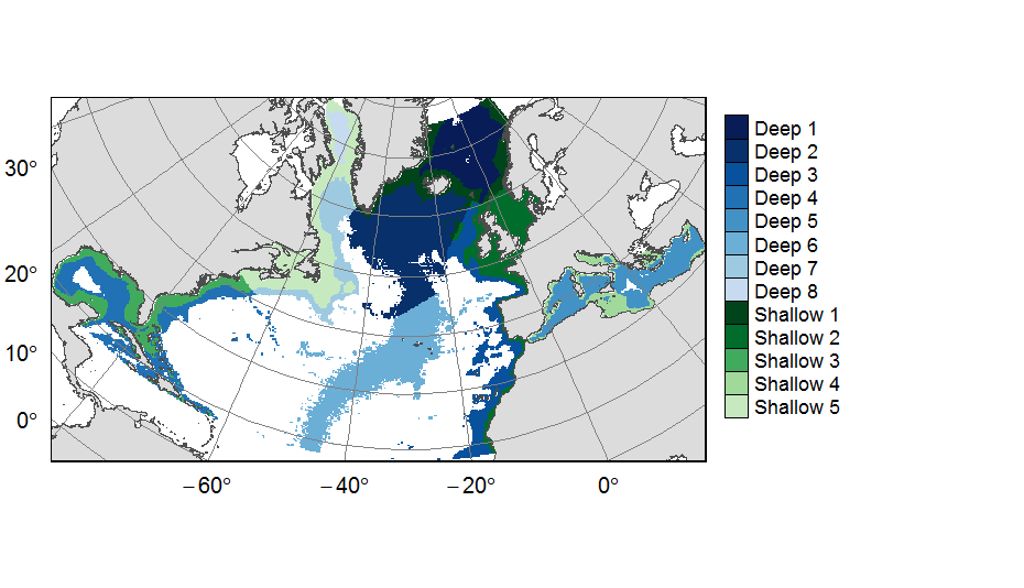
Planning units layers used in ATLAS spatial prioritization on the North Atlantic
Planning units layers used for ATLAS EU prioritization scenarios on the North Atlantic (18°N to 76°N and 36°E to 98°W). This raster layer is designed on a grid of 25km * 25km resolution, that served to extract all the spatial data used prioritization. The 31 518 planning units (cells with value) corresponded to areas containing depths shallower or equal to 3500m, even if they could also contain deeper areas locally. For connectivity scenarios, only the planning units matching with the extent of available connectivity data were selected. One layer allocates planning units to the 13 geographical provinces (values ranging from 1 to 13) created for the purpose of prioritization.
This dataset was built to feed a basin-wide spatial conservation planning exercise, targeting the deep sea of the North Atlantic. The goal of this approach was to identify conservation priority areas for Vulnerable Marine Ecosystems (VMEs) and deep fish species, based on the distribution of species and habitats, human activities and current spatial management.
| Date(s) Date(s) |
|
| Author(s) Auteur(s) |
Combes Magali
(
IFREMER
)
Vaz Sandrine ( IFREMER ) |
| Contact(s) Contact(s) |
IFREMER
|
| Source Source |
Horizon 2020 ATLAS project (EU) |
| Lineage Généalogie |
A 25km * 25 km resolution raster grid was computed using a depth layer of 3km * 3km resolution created by IMAR (Instituto do Mar, Universidade dos Açores, Horta, Portugal) for the ATLAS Deliverable 3.3. Deep (>3500m) areas were excluded and the remaining gridsquares (i.e. the planning units) were either considered as one entity or attributed to 13 regions created for the ATLAS spatial prioritization. Source data reference: Telmo Morato, José-Manuel González-Irusta, Carlos Dominguez-Carrió, Chih-Lin Wei, Andrew Davies, Andrew K. Sweetman, Gerald H. Taranto, Lindsay Beazley, Ana García-Alegre, Anthony Grehan, Pascal Laffargue, F. Javier Murillo, Mar Sacau, Sandrine Vaz, Ellen Kenchington, Sophie Arnaud-Haond, Oisin Callery, Giovanni Chimienti, Erik Cordes, Hronn Egilsdottir, André Freiwald, Ryan Gasbarro, Matt Gianni; Kent Gilkinson, Vonda E. Wareham Hayes, Dierk Hebbeln, Kevin Hedges, Lea-Anne Henry, Georgios Kazanidis, Mariano Koen-Alonso, Cam Lirette, Francesco Mastrototaro, Lénaick Menot, Tina Molodtsova, Pablo Durán Muñoz, Bramley Murton, Covadonga Orejas, Maria Grazia Pennino, Patricia Puerta, Stefán Á. Ragnarsson, Berta Ramiro-Sánchez, Jake Rice, Jesús Rivera, Murray Roberts, Luís Rodrigues, Steve W. Ross, José L. Rueda, Tim Siferd, Paul Snelgrove, David Stirling, Margaret Treble, Javier Urra, Johanne Vad, Les Watling, Wojciech Walkusz, Zeliang Wang, Claudia Wienberg, Mathieu Woillez, Lisa A. Levin, Francis Neat, Diya Das, Laurence Fauconnet, Claudia Viegas, Pedro Afonso, Gui Menezes, Mario Rui Pinho, Helder Silva, Alexandra Rosa, Diana Catarino, Eva Giacomello, Javi Guijarro, Jason Cleland, Isobel Yeo, Joana R. Xavier, Íris Sampaio, Jeremy Spearman, Lissette Victorero, Charles G. Messing, Meri Bilan, Jordi Blasco-Ferre, Jean-François Bourillet, Laurent de Chambure, Jaime S. Davies, Norbert Frank, Brigitte Guillaumont, Konstantinos Georgoulas, Barbara Berx, Karine Olu, Manuela Ramos, Laís Ramalho, Olga Reñones, José Antonio Caballero, Fernando Tempera, Julie Tourolle, Olga Utrilla, Inge van den Beld, Olga Utrilla, Igor Yashayaev, Marina Carreiro-Silva (2019) ATLAS EU D3.3 Biodiversity, biogeography and GOODS classification system under current climate conditions and future IPCC scenarios. https://www.eu-atlas.org/resources/atlas-library |
| Constraints Contraintes |
|
| Spatial informations Informations géographiques |
|
Citation proposal Proposition de citation
Combes Magali , Vaz Sandrine (2019).Planning units layers used in ATLAS spatial prioritization on the North Atlantic.IFREMER
http://dx.doi.org/10.12770/113cd9cb-0a30-4297-b93d-5cf10124105b
)))