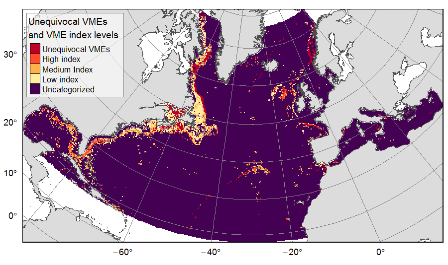
Unequivocal VMEs and VME likelihood on the North Atlantic
Distribution of unequivocal Vulnerable Marine Ecosystems (VMEs) and VME likelihood based on indicator taxa records, on the North Atlantic (18°N to 76°N and 36°E to 98°W). Several datasets, originating from public databases, literature review and data call to ATLAS partners, were gathered to compute the presence of unequivocal VME habitats in 25km * 25 km cells for the ATLAS work package 3. One layer displays the unequivocal VMEs (value=4) and the assigned high (value=3), medium (value=2) or low (value=1) likelihood of gridsquares to host VMEs, indexed on indicator taxa records from public databases with the method detailed in Morato et al (2018). The second displays the confidence associated to the VME likelihood score, indexed on data quality as detailed in Morato et al (2018) (values for unequivocal VMEs thus 100% confidence=4; high confidence=3; medium confidence=2; low confidence=1).
This dataset was built to feed a basin-wide spatial conservation planning exercise, targeting the deep sea of the North Atlantic. The goal of this approach was to identify conservation priority areas for Vulnerable Marine Ecosystems (VMEs) and deep fish species, based on the distribution of species and habitats, human activities and current spatial management.
| Date(s)Date(s) |
|
| Author(s)Auteur(s) | Combes Magali
(IFREMER)
Vaz Sandrine (IFREMER) |
| Contact(s)Contact(s) | IFREMER
|
| SourceSource |
Institut Français de Recherche pour l'Exploitation de la MER (France) |
| LineageGénéalogie |
Records of unequivocal (or bona fide) VMEs were collected from various public sources, the literature and ATLAS partners. Within ATLAS Deliverable 3.4, VME indicator species records were used to develop two indices on the North Atlantic, based on the multi criteria assessment method of Morato et al (2018): a taxa-dependent VME index displaying the likelihood of spatial cells to host VMEs; and an associated index of confidence based on source data quality. From this work, the presence of unequivocal VMEs and VME indices levels were extracted in 25km * 25 km gridsquares of the raster grid used for the ATLAS spatial prioritization. Reference of the ATLAS deliverable: Magali Combes, Sandrine Vaz, Telmo Morato, Laurence Fauconnet, Sophie Arnaud-Haond, Carlos Dominguez-Carrió, Alan Fox, José-Manuel González-Irusta, Marina Carreiro-Silva, Andrew Davies, Pablo Durán Muñoz, Hrönn Egilsdóttir, Lea-Anne Henry, Ellen Kenchington, Camille Lirette, F. Javier Murillo-Perez, Covadonga Orejas, Berta Ramiro-Sánchez, Luís Rodrigues, Steve W. Ross, Dick van Oevelen, Christopher K. Pham, Carlos Pinto, Neil Golding, Jeff A. Ardron, Francis Neat, Xuan Bui, Oisin Callery, Anthony Grehan, Pascal Laffargue, Murray Roberts, David Stirling, Gerald Taranto, Mathieu Woillez, Lénaick Menot. (2019) ATLAS D3.4 Conservation Management Issues in ATLAS. Basin-scale systematic conservation planning: identifying suitable networks for VMEs protection. https://www.eu-atlas.org/resources/atlas-library |
| ConstraintsContraintes |
|
| Spatial informationsInformations géographiques |
|
Citation proposalProposition de citation
Combes Magali, Vaz Sandrine (2019).Unequivocal VMEs and VME likelihood on the North Atlantic.IFREMER
http://dx.doi.org/10.12770/3f14f4aa-ffaa-4152-865f-01be69048fce


)))