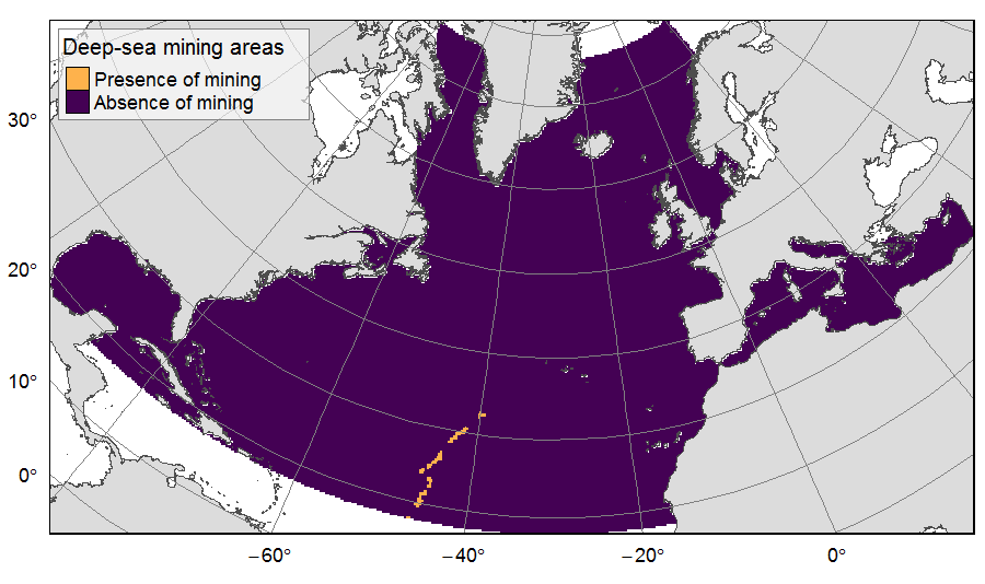
Deep-sea mining activities on the North Atlantic
Presence of deep-sea mining exploration zones on the North Atlantic (18°N to 76°N and 36°E to 98°W). These areas correspond to the three polymetallic sulphides exploration contracts on the Mid-Atlantic Ridge, attributed to Poland, France and Russia. Each of the three contract areas is divided into 100 squares of 10km by 10km. Source polygons originated from the International Seabed Authority. The presence (value=1) of deep-sea mining was extracted in 25km * 25km gridsquares.
This dataset was built to feed a basin-wide spatial conservation planning exercise, targeting the deep sea of the North Atlantic. The goal of this approach was to identify conservation priority areas for Vulnerable Marine Ecosystems (VMEs) and deep fish species, based on the distribution of species and habitats, human activities and current spatial management.
| Date(s)Date(s) |
|
| Author(s)Auteur(s) | Combes Magali
(IFREMER)
Vaz Sandrine (IFREMER) |
| Contact(s)Contact(s) | IFREMER
|
| SourceSource |
Horizon 2020 ATLAS project (EU) |
| LineageGénéalogie |
Source polygons data originated from the International Seabed Authority (ISA). The data was extracted in 25km * 25 km gridsquares of the raster grid used for the ATLAS spatial prioritization. Source data reference: International Seabed Authority (2019). Polymetallic Sulphides/Mid Atlantic Ridge. https://www.isa.org.jm/maps |
| ConstraintsContraintes |
|
| Spatial informationsInformations géographiques |
|
Citation proposalProposition de citation
Combes Magali, Vaz Sandrine (2019).Deep-sea mining activities on the North Atlantic.IFREMER
http://dx.doi.org/10.12770/4ab2fb42-ba5b-418d-9675-a642edfaca70


)))