|
Date(s)
Date(s)
|
-
01-01-2012
(
Creation
Création
)
|
|
Contact(s)
Contact(s)
|
Artigas Luis Felipe
(
Laboratoire d’Océanographie et de Géosciences
)
|
|
Source
Source
|
Producteurs de données :ULCO, UL1, CNRS (UMR LOG, Wimereux), IFREMER LER Boulogne sur Mer, CEFAS Lowestoft (U.K.), Rijkswaterstaat Waterdienst (NL)
Data producers : ULCO, UL1, CNRS (UMR LOG, Wimereux), IFREMER LER Boulogne sur Mer, CEFAS Lowestoft (U.K.), Rijkswaterstaat Waterdienst (NL)
|
|
Lineage
Généalogie
|
Programmée à l’origine uniquement pendant la seconde quinzaine d’avril 2012, il a bénéficié d’une seconde partie fin mai-début juin 2012, qui a permis de compléter la couverture spatiale.
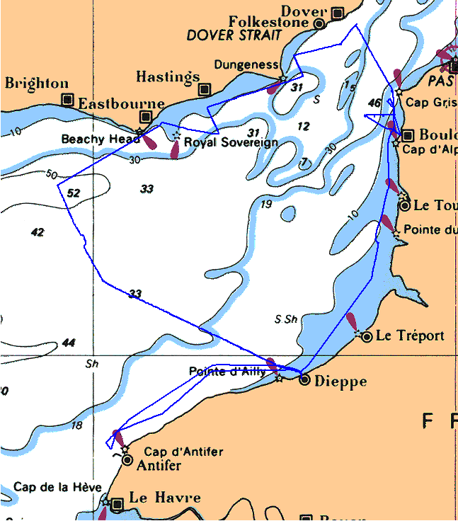
Il s’agit des premières mesures en continu et avec une grande couverture spatiale de la répartition, structure et dynamique des communautés phytoplanctoniques des deux côtés de la Manche Orientale. Les résultats préliminaires confirment la grande diversité de systèmes pélagiques considérés et a permis de suivre la limite dynamique entre ces systèmes.
Ces campagnes font partie des trois campagnes de mesures en mer communes organisées entre 2011 et 2012 en Manche et Mer du Nord : la campagne Cefas Endeavour en Mer du Nord en mai 2011, la campagne DYPHYMA en Manche au printemps 2012 et la campagne dans les estuaires néerlandais en septembre 2012.
Une répétition de ce parcours à différentes périodes de l’année permettrait de mettre en évidence les limites dynamiques de ces systèmes ainsi que la diversité des micro-algues qui les caractérisent. De même, une possibilité de pérenniser ce dispositif serait à envisager à la fois par l’application des techniques innovantes sur des lignes de ferry ou navires de recherche, tout comme dans des bouées in situ.
Nombre de points d'observation ou de mesure : 70 échantillons discrets et plusieurs centaines d’enregistrements en continu
This project, which was initially only planned for the second half of April 2012, was continued at the end of May and beginning of June in 2012, thus completing coverage of the area
These are the first continuous measurements to study distribution, structure and dynamics of phytoplankton communities in the Western English Channel over a large area. Preliminary results confirm the great diversity of the pelagic systems studied and have made it possible to monitor the limit of the dynamics between these systems.
These campaigns are parts of three measurement campaigns in shared seas organised between 2011 and 2012 in the Channel and North Sea: The Cefas Endeavor campaign in the North sea in May 2011, the DYPHYMA campaign in the Channel in Spring 2012 and the campaign in estuaries in the Netherlands in September 2012. Repeating this route at different times of year highlights the dynamic limitations of these systems as well as the diversity of the microalgae which characterise them. In the same way, to continue this programme in the future, it would be possible both to apply innovative techniques to ferry lines or research vessels, and to use in situ buoys.
Number of observation or measurement points: 70 discrete samples and hundreds of condinuous recordings
|
|
Constraints
Contraintes
|
-
Limitation d'utilisation
Use limitation
-
Les données sont mises à disposition des partenaires du projet, puis, par la suite, seront rendues accessibles à la communauté scientifique, notamment après valorisation par les producteurs des données sous forme de publications scientifiques. Obligation de faire référence au projet DYMAPHY, au programme INTERREG IVA « 2 Mers », au co-financement européen de type FEDER et des partenaires (ULCO, UL1, CNRS, IFREMER, CEFAS, RWS).
The data are made available by the project partners, and will later be made available for the scientific community, particularly after optimisation by the data producers in scientific publications. In any publication, references must be credited to the DYMAPHY project, the INTERREG IVA « 2 Mers » programme, European financial backing such as FEDER and to partners (ULCO, UL1, CNRS, IFREMER, CEFAS, RWS).
-
Autres contraintes
Other legal constraints
-
|
|
Spatial informations
Informations géographiques
|
-
Data type
Type de données
-
Vector
Vecteur
-
Scale
Échelle
-
1:50000
-
Coordinate system
Système de coordonnées
- WGS 84 (EPSG:4326)
|
)))