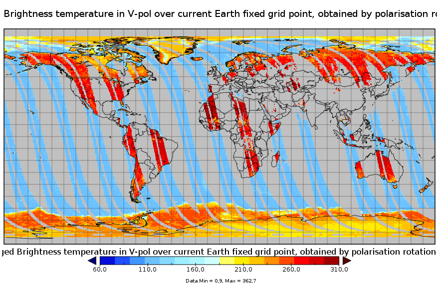
CATDS-PDC L3TB - Global polarised brightness temperature product from SMOS satellite
This product is a synthesis product of brightness temperatures for L-Band frequency. It includes all brightness temperatures acquired that very day by the SMOS satellite operating in full pol mode. Values correspond to those at the top of the atmosphere level, transformed to the ground polarisation reference frame, binned and averaged into fixed incidence angle classes. This product is available on each of the EASE2 grid projections (cylindrical and polar).
| Date(s) Date(s) |
|
| Author(s) Auteur(s) |
CATDS
|
| Contact(s) Contact(s) |
Arnaud Mialon
(
CESBIO
)
CATDS (CNES, IFREMER, CESBIO) |
| Source Source |
CATDS (CNES, IFREMER, CESBIO) |
| Lineage Généalogie |
The base products, for all the CATDS-PDC (Centre Aval de Traitement des Données SMOS - Production & Dissemination Center) processing chains, are the SMOS L1B products - https://doi.org/10.57780/SM1-e20cf57 - from ESA (European Space Agency). The L3TB product includes all brightness temperatures from SMOS satellite acquired that day, at top of atmosphere level, transformed to ground polarisation reference frame, filtered when several acquisitions are available, and binned and averaged into fixed incidence angle classes (including a 40° incidence angle, to ease the comparison with SMAP data). This product is available on each of the EASE2 grid projections (cylindrical and polar). For the cylindrical projection : Ascending and descending orbits are processed separately, and only in full polarisation. For the polar projections : Each orbit (equator to equator) is processed separately. Products from reprocessing RE07 are available for the period 01/2010 - 05/2021. Products from operational (OPER) processing are available since 05/2021. In this product, the brightness temperature values potentially contaminated by RFI or by the sun are no longer removed from the data. Instead, 2 new counter fields (Nb_RFI_Flags and NB_SUN_Flags) have been added, in order to count the number of views identified as contaminated. Therefore a low counter value means a low probability of contamination, and a high counter value means a high probability of contamination. Please note that the historical serie of the polar product is known to have a grid shift (more info at https://www.catds.fr/News/New-L3-TB-polar-grid-correction-of-the-geolocation-shift ) File naming : SM_clas_MIR_CDF3Tx_startdate_enddate_vvv_ccc_7 - clas : File class (OPER : operational mode, REXX : reprocessing xx, TEST : for polar projection) - x : A for ascending orbit, D for descending orbit, N for north pole, S for south pole - startdate : sensing start date/time of the data (format yyyymmddThhmiss) - enddate : sensing end date/time of the data (format yyyymmddThhmiss) - vvv : version number of the processor generating the product - ccc : file counter File format : In each archive file (.tgz extension), there are two files - A Header file (.HDR), which is a text file, in XML Earth Explorer Header format - A Data file (.DBL.nc), which is a netcdf file, format variant 2 (netcdf 3 with 64 bits offset option) Reference : Al Bitar Ahmad, Mialon Arnaud, Kerr Yann H., Cabot Francois, Richaume Philippe, Jacquette Elsa, Quesney Arnaud, Mahmoodi Ali, Tarot Stephane, Parrens Marie, Al-Yaari Amen, Pellarin Thierry, Rodriguez-Fernandez Nemesio, Wigneron Jean-Pierre (2017). The global SMOS Level 3 daily soil moisture and brightness temperature maps. Earth System Science Data, 9(1), 293-315. Publisher's official version : http://doi.org/10.5194/essd-9-293-2017 , Open Access version : http://archimer.ifremer.fr/doc/00388/49941/ |
| Constraints Contraintes |
|
| Spatial informations Informations géographiques |
|
Citation proposal Proposition de citation
CATDS (2022).CATDS-PDC L3TB - Global polarised brightness temperature product from SMOS satellite.CATDS (CNES, IFREMER, CESBIO)
http://dx.doi.org/10.12770/6294e08c-baec-4282-a251-33fee22ec67f
When using this dataset in a publication, also cite the related work(s) with:
Al Bitar Ahmad, Mialon Arnaud, Kerr Yann H., Cabot Francois, Richaume Philippe, Jacquette Elsa, Quesney Arnaud, Mahmoodi Ali, Tarot Stephane, Parrens Marie, Al-Yaari Amen, Pellarin Thierry, Rodriguez-Fernandez Nemesio, Wigneron Jean-Pierre (2017). The global SMOS Level 3 daily soil moisture and brightness temperature maps. Earth System Science Data, 9(1), 293-315. Publisher's official version : http://doi.org/10.5194/essd-9-293-2017 , Open Access version : http://archimer.ifremer.fr/doc/00388/49941/
)))