National Observation Service Dynalit, focuses on Coastline by satellite image
SNO Dynalit "Trait de Côte" par image satellite, Ile de la Réunion
نموذج البيانات الموجهة في ISO19139 (متعددة اللغات)
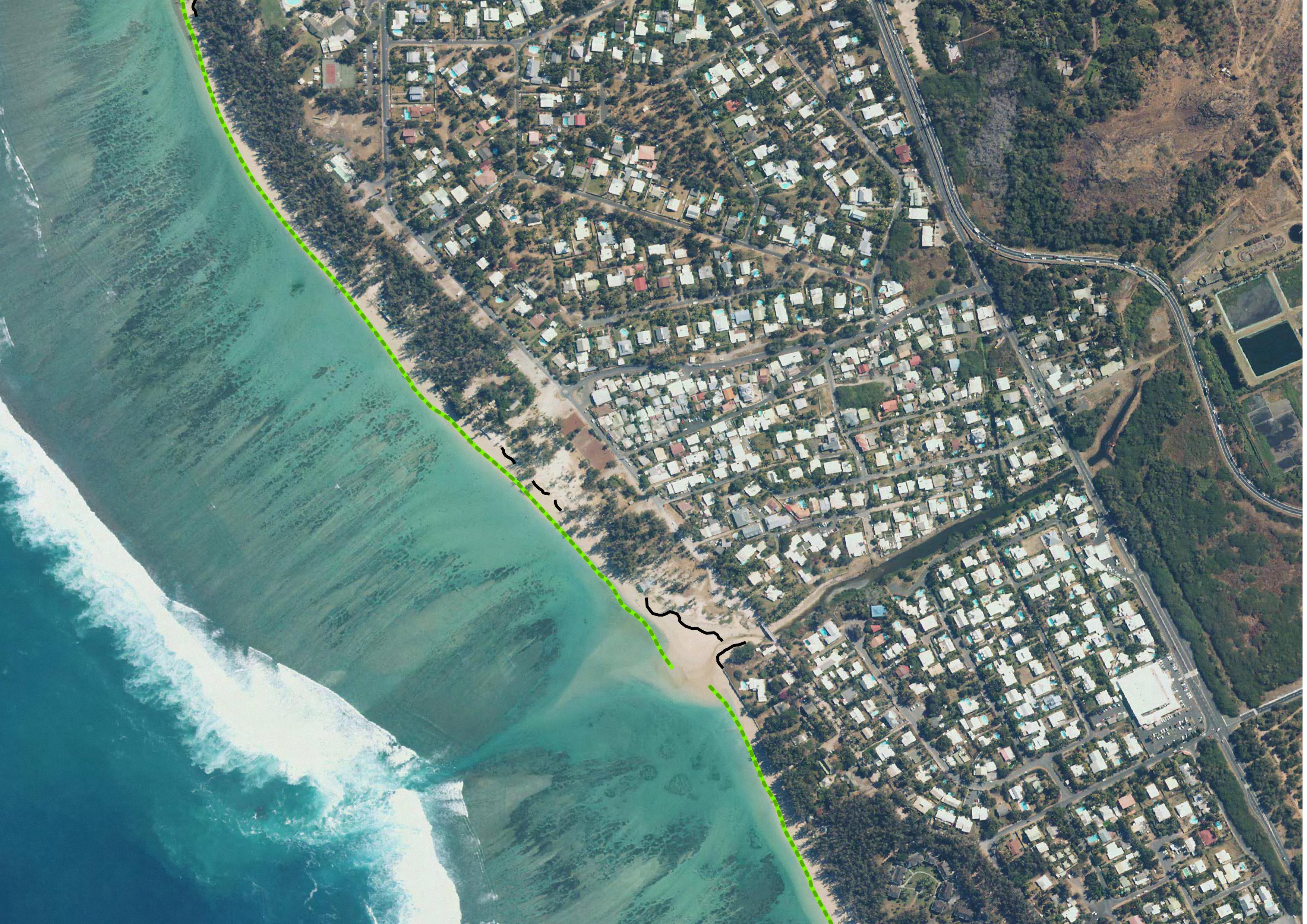
The coastline or shoreline is the geographical boundary between sea and land. It corresponds according to the SHOM to "the leash of the highest seas in the context of an astronomical tide of coefficient 120 and under normal weather conditions (without overcost phenomenon). The coastline as defined above is not directly identifiable continuously on the ground or on a satellite or aerial image. From a perspective of studying the displacement of the shoreline, indicators allow us to approach this notion (the vegetation limit associated with the infrastructure limit, the beach limit, etc.).
On the reef shoreline of Reunion Island the limit of vegetation and infrastructure as well as beach limit were retained. This limit results in the production of a line-type vector geographic information layer in a GIS resulting from the photo-interpolation on Pléiades satellite images. Pleiades satellite images from the Kalideos Réunion database (CNES) have been used since 2016 to study the position of the shoreline annually. Launched in 2011, Pléiades is a very high spatial resolution spatial image system (panchromatic optical instrument at 70 cm and 2.8 m multispectral) operating in the visible and near infrared with a swath of 20 km
UMR Espace-Dev
Le trait de côte ou la ligne de rivage est la limite géographique entre mer et terre. Il correspond d’après le SHOM à « la laisse des plus hautes mers dans le cadre d'une marée astronomique de coefficient 120 et dans des conditions météorologiques normales (sans phénomène de surcôte). Le trait de côte tel que défini ci-dessus n'est pas directement repérable de façon continue sur le terrain ou sur une image satellite ou aérienne. Dans une perspective d’étudier le déplacement du rivage des indicateurs permettent d’approcher cette notion (la limite de végétation associée à la limite des infrastructures, le pied de plage,….).
Sur le littoral récifal de l’île de La Réunion la limite de végétation et d’infrastructure ainsi que de pied de plage ont été retenue. Cette limite se traduit par la production d’une couche d’information géographique vecteur de type ligne dans un SIG résultat de la photo-interpétration sur d’images satellites Pléiades. Les images satellitaires Pléiades issues de la base de données Kalidéos Réunion (CNES) sont utilisées depuis 2016 pour étudier la position du rivage annuellement. Lancé en 2011, Pléiades est un système d’images spatiales à très haute résolution spatiale (instrument optique panchromatique à 70 cm et 2,8 m en multispectral) opérant dans le visible et le proche infrarouge avec une fauchée de 20 km
UMR Espace-Dev
Die ISO19115 Metadaten-Standard ist der bevorzugte Metadaten-Standard zu verwenden. Diese Vorlage ist mehrsprachig mit einer Standard-Sprache auf Englisch. Andere Sprache verwendet werden könnten, um Teil der Metadaten werden. Sprache definieren, ist in Abschnitt Metadaten. Weitere Sprachen können hinzugefügt werden, um Metadaten Abschnitt / locale Element.
元数据标准的ISO19115是首选元数据标准使用。这个模板是多语种的默认语言设置为英语。其他语言可以用来翻译部分的元数据记录。主要语言是界定元一节。其他语言可以增加元数据节/地区因素。
فإن معيار ISO19115 الفوقية هو المفضل لاستخدام البيانات الوصفية القياسية. هذا القالب هو متعدد اللغات مع اللغة الافتراضية لمجموعة الانجليزية. لغة أخرى يمكن استخدامها لتحويل جزء من الفوقية. اللغة الرئيسية هي تحديد الفوقية في هذا الباب. لغات أخرى يمكن أن تضاف إلى الباب الفوقية / عنصر المكان.
El estándar de metadatos ISO19115 es el estándar de metadatos a utilizar. Esta plantilla es multilingüe, con un idioma por defecto configurado en Inglés. En otros idiomas puede ser usado para traducir parte del registro de metadatos. Idioma principal es definir los metadatos en la sección. Otros idiomas pueden ser añadidos a la sección de metadatos / locale elemento.
В метаданных стандарта ISO19115 предпочтительным является стандарт метаданных для использования. Этот шаблон многоязычный с языком по умолчанию установлен на английском языке. Другие языки могут использоваться для перевода части метаданных записи. Основным языком является определение метаданных разделе. Другие языки могут быть добавлены метаданные раздел / локаль элемент.

)))