145_DTM_CNR-ISMAR-22_Adriatic_singlebeam
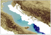
Bathymetry of the Adriatic Sea compiled by CNR-ISMAR for the Italian side of the Adriatic Sea to illustrate the main geological features of the Western Adriatic Basin using a single beam echosouder.
What
Metadata details
- File identifier
- SDN_CPRD_145_DTM_CNR-ISMAR-22
- Catalogue type
-
Composite Product Record
-
Project name
-
-
EMODNet Seabed Mapping
-
- Dissemination level
-
public
- Metadata language
- English
- Date stamp
- 2020-06-04T00:28:23
Identification
- Dataset name
-
145_DTM_CNR-ISMAR-22_Adriatic_singlebeam
- Short name of dataset (SDN Local Product-ID)
-
DTM_CNR-ISMAR-22
-
Parameter Discovery Vocabulary (P02)
-
-
Bathymetry and Elevation
-
-
SeaDataNet device categories
-
-
single-beam echosounders
-
-
SeaDataNet device categories
-
-
Differential Global Positioning System receivers
-
Geometry
- Spatial representation type
- Grid
- Number of columns
- 4123
- Number of lines
- 4741
- Pixel size
- 200 Metres (m)
- Maximum scale of use
- 50000
Abstract
- Dataset description abstract
-
Bathymetry of the Adriatic Sea compiled by CNR-ISMAR for the Italian side of the Adriatic Sea to illustrate the main geological features of the Western Adriatic Basin using a single beam echosouder.
- Description of processed data sources
-
Description of processed data sources :
Single Beam sonar data were collected using an hull-mounted Echo sounder (Atlas Deso25 operating at frequencies of 12, 100, 33 and 210KHz) along about 17.830 km of seismic profiles during 22 cruises performed by ISMAR from 1991 to 2005 on board R/V Urania in the Italian side of the Adriatic Sea. The echo sounding profiles are unevenly distributed and the seafloor coverage is within the range of one sounding every 20-40 m, along track. The Echo sounder Atlas Deso25 was merged with the navigation system NAV PRO from Communication Technology and with DGPS positioning system with metrical accuracy.
CDIs list of single beam echosounder surveys using single beam echosounder (18) used to produce the DTM :
145_CNR-ISMAR-23,145_CNR-ISMAR-24, 145_CNR-ISMAR-25, 145_CNR-ISMAR-26, 145_CNR-ISMAR-27, 145_CNR-ISMAR-28, 145_CNR-ISMAR-29, 145_CNR-ISMAR-30, 145_CNR-ISMAR-31, 145_CNR-ISMAR-32, 145_CNR-ISMAR-33, 145_CNR-ISMAR-34, 145_CNR-ISMAR-35, 145_CNR-ISMAR-36, 145_CNR-ISMAR-37, 145_CNR-ISMAR-38, 145_CNR-ISMAR-39, 145_CNR-ISMAR-40.
- Description of data processing
-
Description of data processing :
The bathymetric data were migrated in a GIS Database and plotted as water depth points on different maps, at different scale depending on the soundings density, dividing the Adriatic in subset areas from north to south. Following an interpretative approach, based also on the interpretation of geological sub-seafloor features using CHIRP-sonar profiles, the bathymetric contours were manually drawn and digitised as vector data in a GIS, with variable space according to water depth range (contour every 1 m from 5 to 150 m and every 20 m from 150 m to 1200 m). The contours were used to generate a uniform GRID (200 m) using a kriging algorithm with variable resolution depending on the soundings density.
- Processing software
-
PANGEA Multi Beam Manager
Quality
Accuracy / Calibration
Hor. accuracy
- Measure description
-
Variable quality depending on time of data collection. High accuracy given by a manual interpretation and contouring before gridding.
Vert. accuracy
- Evaluation method description
-
CTD calibration especially in areas with variable sound speed profiles.
Suitability
- Suitability, Expected type of users / uses and limitations
-
The Single Beam bathymetry of the Italian side of the Adriatic compiled by ISMAR can be applied in oceanographic numerical model as uniform resolution GRID. The main advantages in using this kind of bathymetry, obtained from manual interpretation and contouring, is the generation of consistent model taking into account the actual sea floor morphology and its relation to key geological features. The main limitation come from the heterogeneity of the bathymetric data in terms of distribution and quality, and the possible errors generated during the interpolation procedures applied to derive an homogeneous resolution GRID. Not for navigation
Quality Indicators
- Horizontal Quality Indicator
- 3 - < 20 m
- Vertical Quality Indicator
- 1 - SBES low frequency, SDB (similar than 2+5%d)
- Purpose Quality Indicator
- 2 - Bathymetric/morphologic survey
Where
))
- Min. depth in meters (>0 below Sea Level)
- 114
- Max. depth in meters (>0 below Sea Level)
- 1204
Projection
- code
-
WGS 84 (EPSG:4326)
- Version or custom projection details
-
7.4
When
Creation date
Revision date
Temporal extent*
- Begin
- 1991-05-18T12:00:00
- End
- 2005-03-17T12:00:00
Who
Originator
- Organisation name
-
Consiglio Nazionale Delle Ricerche / ISTITUTO DI SCIENZE MARINE (ISMAR) - SEZIONE DI BOLOGNA
Data Holding Center
- Organisation name
-
Consiglio Nazionale Delle Ricerche / ISTITUTO DI SCIENZE MARINE (ISMAR) - SEZIONE DI BOLOGNA
Collating Centre = Metadata author
- Organisation name
-
Consiglio Nazionale Delle Ricerche / ISTITUTO DI SCIENZE MARINE (ISMAR) - SEZIONE DI BOLOGNA
Access
Distributor
- Organisation name
-
Consiglio Nazionale Delle Ricerche / ISTITUTO DI SCIENZE MARINE (ISMAR) - SEZIONE DI BOLOGNA
Data formats*
- Format
-
ArcGIS Ad_tot_sb.asc, Ad_tot_sb.xyz
- Version
-
Not specified
- Transfer size (in MB)
- 60
- OnLine resource
-
Protocol Linkage Name WWW:LINK
ftp.ismar.cnr.it ISMAR FTP
Intellectual property
- Access constraints
- Restricted
- Use constraints
- Copyright
- Other constraints
-
Intellectual property : CNR-ISMAR Bologna
Obligation of citation :
The bathymetry of the Adriatic Sea, F.Foglini(1), E. Campiani(1), A.Cattaneo(2), A. Correggiari (1), A.Remia (1), D.Ridente(3), F.Trincardi(1), 2011. Marine Research@CNR pp. 445-458
)))