145_DTM_CNR-ISMAR-51_RER2006_Adriatic_Emilia-Romagna
Digital bathymetric model in grid format. The product represents the bathymetry using a model cell that is associated with regular information on the depth of the Adriatic Sea in front of the Emilia Romagna Region.
What
Metadata details
- File identifier
- SDN_CPRD_145_DTM_CNR-ISMAR-51
- Catalogue type
-
Composite Product Record
-
Project name
-
-
EMODNet Seabed Mapping
-
- Dissemination level
-
public
- Metadata language
- English
- Date stamp
- 2020-06-04T00:27:36
Identification
- Dataset name
-
145_DTM_CNR-ISMAR-51_RER2006_Adriatic_Emilia-Romagna
- Short name of dataset (SDN Local Product-ID)
-
DTM_CNR-ISMAR-51
-
Parameter Discovery Vocabulary (P02)
-
-
Bathymetry and Elevation
-
-
Measuring devices
-
-
single-beam echosounders
-
multi-beam echosounders
-
-
Measuring devices
-
-
Differential Global Positioning System receivers
-
Geometry
- Spatial representation type
- Grid
- Number of columns
- 2705
- Number of lines
- 3806
- Pixel size
- 0.00022381099 Degrees north (degree_north)
- Maximum scale of use
- 10000
Abstract
- Dataset description abstract
-
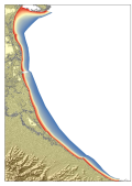
Digital bathymetric model in grid format. The product represents the bathymetry using a model cell that is associated with regular information on the depth of the Adriatic Sea in front of the Emilia Romagna Region.
- Description of processed data sources
-
Description of processed data sources :
Data were provided by ARPA-Environmental Engineering who has been active in monitoring on behalf of the Emilia-Romagna. The measurements were conducted by Geosystems Ltd of Parma, who took over the whole coast region, to a depth of about 8-9 m along 251 transects perpendicular to the shoreline spaced about 500 meters and a series of transverse lines of relief , for a total of 200 km. Data were collected with multiple echosounders:
1. Sinlge beam echo sounder (200 KHz) for the shallow water areas up to 1.5m
2. multi beam echosounder (455 Khz and max swath angle of 120°) for water depth up to 10m.
- Description of data processing
-
Description of data processing :
The bathymetric soundings were distributed not homogenously along he major transect and the DTM was derived both from soundings and countours manually drawn. Multi beam soundings were filtered (low filter)to remove spikes particularly those present at the edges of the tracklines. A first processing produced a DTM with a resolution of 10m, and contour lines every 0.25m Contours generated automatically were subjected subsequently to a manual correction, taking into account the distribution of data and the presence of natural and man-made structures deduced from the photo-interpretation of the flight Costa 2005. The final product is a series of contour lines of both the emerged part and the submerged part with equidistance 0.25 but starting from +3.5 to -10 m
Quality
Accuracy / Calibration
Suitability
- Suitability, Expected type of users / uses and limitations
-
The RER2006 DTM can be used to asses the sedimentary processes and geohazards along the costal areas of the Emilia Romagna Region in very shallow water. This data are not suitable for navigation and positioning
Where
))
- Min. depth in meters (>0 below Sea Level)
- 0
- Max. depth in meters (>0 below Sea Level)
- 10
Projection
- code
-
WGS 84 (EPSG:4326)
- Version or custom projection details
-
7.4
When
Creation date
Revision date
Temporal extent*
- Begin
- 1991-05-18T11:33:00
- End
- 2005-03-17T09:00:00
Who
Originator
Data Holding Center
Collating Centre = Metadata author
Access
Distributor
- Organisation name
-
Consiglio Nazionale delle Ricerche ISMAR
Data formats*
- Format
-
RER206.asc
- Version
-
NA
- Transfer size (in MB)
- 39
- OnLine resource
-
Protocol Linkage Name WWW:LINK
ftp.ismar.cnr.it ISMAR FTP
Intellectual property
- Use limitation
-
Copyright and obligation of citation
- Access constraints
- Intellectual property rights
- Use constraints
- Copyright
- Other constraints
-
Emilia-Romagna Region (Italy)
)))