2243_EMODNet DTM of the Belgian Multibeam Surveys for the coastal waters
Source data for the EMODNet DTM for the Belgium Coastal Waters is compiled by the Vlaamse Hydrografie ( http://www.afdelingkust.be/en/bathymetric-database) at a resolution of 1/512 arc minute.
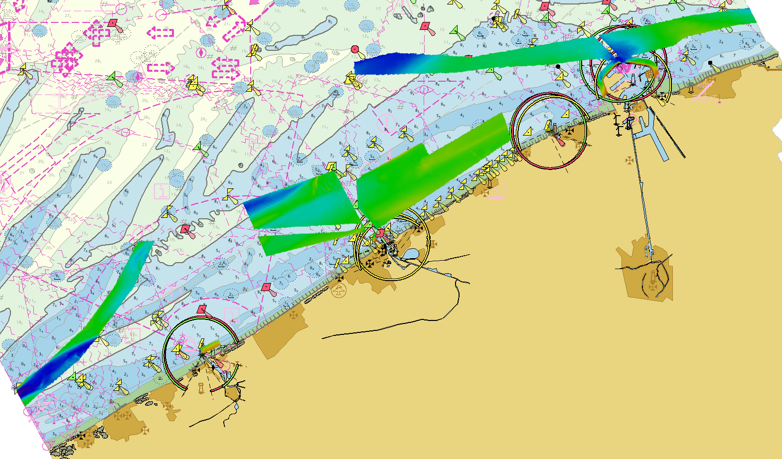
The data set covers the waters along the Belgian coast.
What
Metadata details
- File identifier
- SDN_CPRD_2243_BELGIUM_MULTIBEAM_COASTAL_DTM010218
- Catalogue type
-
Composite Product Record
-
Project name
-
-
EMODnet HRSM
-
- Dissemination level
-
public
- Metadata language
- English
- Date stamp
- 2022-09-20T15:28:11.554Z
Identification
- Dataset name
-
2243_EMODNet DTM of the Belgian Multibeam Surveys for the coastal waters
- Short name of dataset (SDN Local Product-ID)
-
BELGIUM_MULTIBEAM_COASTAL_DTM010218
-
Parameter Discovery Vocabulary (P02)
-
-
Bathymetry and Elevation
-
-
SeaDataNet device categories
-
-
multi-beam echosounders
-
Geometry
- Spatial representation type
- Grid
- Pixel size
- 0.001953 Arc minute
- Maximum scale of use
- 50000
Abstract
- Dataset description abstract
-
Source data for the EMODNet DTM for the Belgium Coastal Waters is compiled by the Vlaamse Hydrografie ( http://www.afdelingkust.be/en/bathymetric-database) at a resolution of 1/512 arc minute.
The data set covers the waters along the Belgian coast.
- Description of processed data sources
-
Description of processed data sources: Description of processed data sources: various multibeam surveys collected for compilation of nautical charts.
- Description of data processing
-
Description of data processing :
The original data is delivered in longitude/latitude (non projected) coordinates in the EMODnet format adding the required field using the CARIS BathyDatabase software suite.
List of the survey projects used to combine the EMODNet DTM for the Belgium Coastal Waters:
160920_ZB_STRD_MB_300 Strekdammen 1/512 arc minute
170209_WIESCH_MB_300 Zeegebied_Banken_Detail_Offshore_WIESCH 1/512 arc minute
170503_ZUYWE_MB_300 Zeegebied_Banken_Detail_Offshore_ZUYWE 1/512 arc minute
170627_WEDHA_MB_300 Zeegebied_Banken_Detail_Offshore_WEDHA 1/512 arc minute
170706_WEDHA_MB_300 Zeegebied_Banken_Detail_Offshore_WEDHA 1/512 arc minute
170922_OST_STRD_MB_300 Zeegebied_Havens_OST_STRD 1/512 arc minute
170927_ODKMK_MB_400 Lombardsijde 1/512 arc minute
171220_ODKMK_MB_400 Zeegebied_Vooroever_ODKMK 1/512 arc minute
180115_BKB_HAV_MB_300 Zeegebied_Havens_BKB_HAV 1/512 arc minute
- Processing software
-
CARIS BathyDatabase software suite
Quality
Accuracy / Calibration
Hor. accuracy
- Measure description
-
IHO S-44
- Value
- IHO S-44
- Evaluation method description
-
IHO S-44
Vert. accuracy
- Measure description
-
IHO S-44
- Evaluation method description
-
IHO S-44
Quality Indicators
- Horizontal Quality Indicator
- 3 - < 20 m
- Vertical Quality Indicator
- 4 - MBES High frequency (higher that 100kHz) (1+0.5%d)
- Purpose Quality Indicator
- 3 - Hydrographic survey or compatible with hydrographic standards
Where
))
- Min. depth in meters (>0 below Sea Level)
- -5.2
- Max. depth in meters (>0 below Sea Level)
- 18.7
Projection
- code
-
ETRS89 (EPSG:4258)
- Version or custom projection details
-
8.6
When
Creation date
Revision date
Temporal extent*
- Begin
- 2016-09-20T09:00:00
- End
- 2018-01-15T17:00:00 Before
Who
Originator
- Organisation name
-
Flemish Ministry of Mobility and Public Works; Agency for Maritime and Coastal Services; Coastal Division
- Country
-
Belgium
Data Holding Center
- Organisation name
-
Flemish Ministry of Mobility and Public Works; Agency for Maritime and Coastal Services; Coastal Division
- Country
-
Belgium
Collating Centre = Metadata author
- Organisation name
-
Flemish Ministry of Mobility and Public Works; Agency for Maritime and Coastal Services; Coastal Division
- Country
-
Belgium
Access
Distributor
- Organisation name
-
Flemish Ministry of Mobility and Public Works; Agency for Maritime and Coastal Services; Coastal Division
- Country
-
Belgium
Data formats*
- Format
-
GeoTIFF
- Version
-
1.0
- Format
-
BAG
- Version
-
1.5.2
- Format
-
PNG
- Version
-
1.0
- Format
-
JPEG
- Version
-
1.0
- Format
-
XYZ Ascii
- Version
-
1.0
- OnLine resource
-
Protocol Linkage Name WWW:LINK
https://www.afdelingkust.be/en/bathymetric-database WWW:DOWNLOAD-1.0-link--download
https://downloads.emodnet-bathymetry.eu/high_resolution/2243_BELGIUM_MULTIBEAM_COASTAL_DTM010218.emo.zip WWW:LINK
https://tiles.emodnet-bathymetry.eu/ EMODnet Bathymetry WMTS service
WWW:LINK-1.0-http--link
https://emodnet.ec.europa.eu/geoviewer EMODnet viewer
Intellectual property
- Access constraints
- Creative Commons Attribution 4.0 International
- Use constraints
- Other restrictions
- Other constraints
-
DO NOT USE FOR NAVIGATION
)))