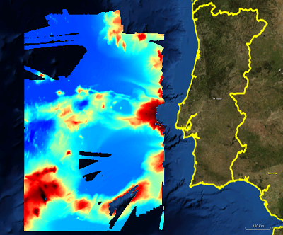
2979_EMEPC_MB_500_Central_Continental_Shelf_Portugal
500m gridded dataset extracted from Portuguese EMEPC multibeam hydrographic surveys,
performed within the scope of the Portuguese Continental Shelf Extension Project (UNCLOS)
What
Metadata details
- File identifier
- SDN_CPRD_2979_EMEPC_MB_500_CONT
- Catalogue type
-
Composite Product Record
-
Project name
-
-
EMODNet Hydrography
-
- Dissemination level
-
confidential
- Metadata language
- English
- Date stamp
- 2018-01-29T16:50:43
Identification
- Dataset name
-
2979_EMEPC_MB_500_Central_Continental_Shelf_Portugal
- Short name of dataset (SDN Local Product-ID)
-
EMEPC_MB_500_CONT
-
Parameter Discovery Vocabulary (P02)
-
-
Bathymetry and Elevation
-
-
SeaDataNet device categories
-
-
multi-beam echosounders
-
-
SeaDataNet device categories
-
-
Differential Global Positioning System receivers
-
Geometry
- Spatial representation type
- Grid
- Number of columns
- 1524
- Number of lines
- 1532
- Pixel size
- 500 Metres (m)
- Maximum scale of use
- 200000
Abstract
- Dataset description abstract
-
500m gridded dataset extracted from Portuguese EMEPC multibeam hydrographic surveys,
performed within the scope of the Portuguese Continental Shelf Extension Project (UNCLOS)
- Description of processed data sources
-
Description of processed data sources :sea surface surveys, with Kongsberg EM 120 Multibeam Echosounder
- Description of data processing
-
Description of data processing :CARIS HIPS Data processing and Validation Proceduures. Sound Velocity Profiles were made whenever the sound velocity presented significant variations.
- Processing software
-
Caris Hips and Sips
Quality
Accuracy / Calibration
Hor. accuracy
- Measure description
-
Not specified
- Evaluation method description
-
Hydrographic standard
Vert. accuracy
- Measure description
-
Not specified
- Evaluation method description
-
Hydrographic standard
Quality Indicators
- Horizontal Quality Indicator
- 3 - < 20 m
- Vertical Quality Indicator
- 2 - MBES low frequency (lower than 100kHz) (similar than 1+2%d)
- Purpose Quality Indicator
- 3 - Hydrographic survey or compatible with hydrographic standards
Where
))
- Min. depth in meters (>0 below Sea Level)
- 184
- Max. depth in meters (>0 below Sea Level)
- 5687
Projection
- code
-
WGS 84 (EPSG:4326)
- Version or custom projection details
-
7.4
When
Creation date
Revision date
Temporal extent*
- Begin
- 2004-09-28T01:00:00
- End
- 2005-12-19T01:00:00
Who
Originator
- Organisation name
-
EMEPC
Data Holding Center
- Organisation name
-
EMEPC
Collating Centre = Metadata author
Access
Distributor
- Organisation name
-
EMEPC
Data formats*
- Format
-
Text
- Version
-
1
- Transfer size (in MB)
- 40
- OnLine resource
-
Protocol Linkage Name WWW:LINK
http://www.emepc.pt
Intellectual property
- Access constraints
- Restricted
- Use constraints
- Copyright
)))