Cyprus-Compilation-from-25m-grids-0.25min-Geo
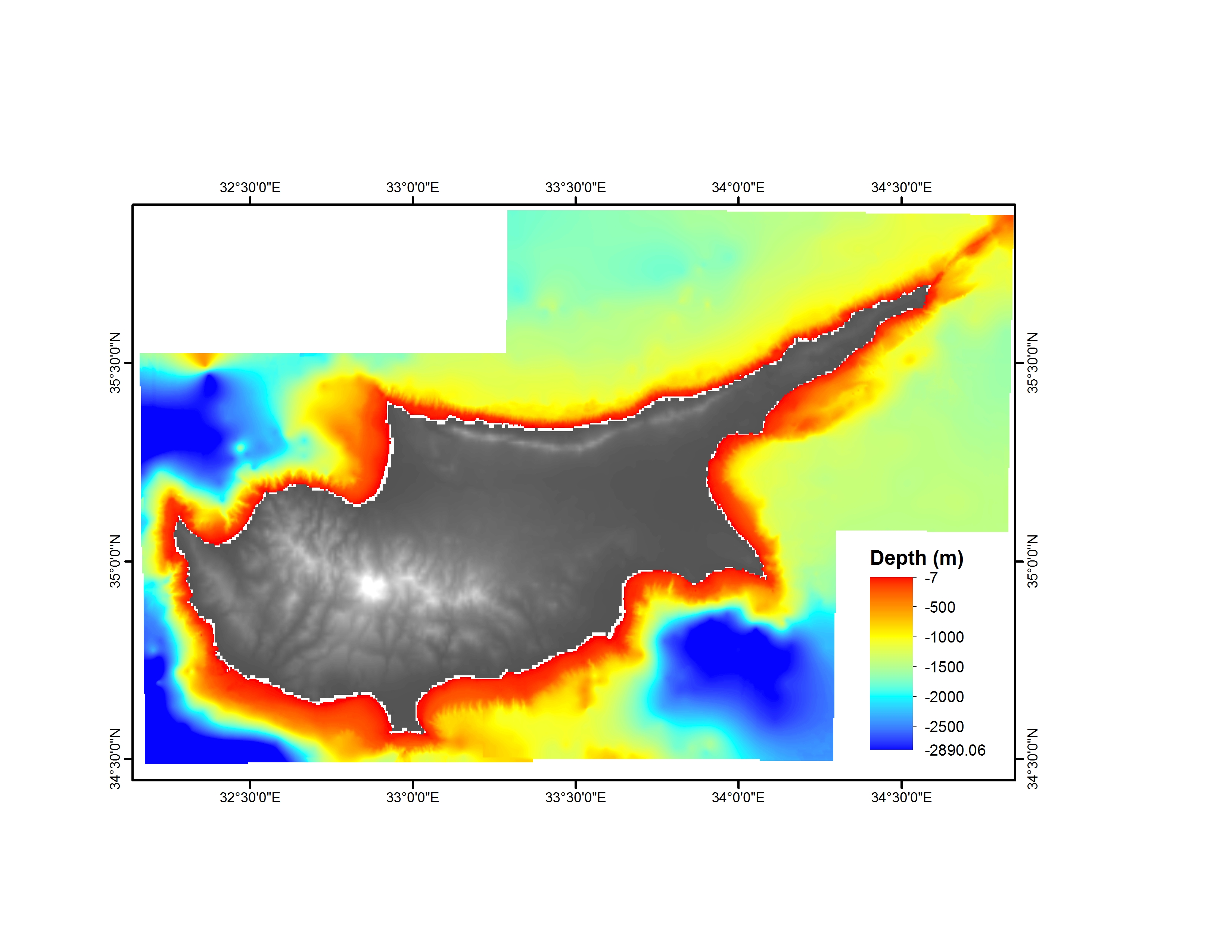
Composite DTM: 25 m grid of the shelf off Cyprus, scale reduced to 0.25 minutes. It is based on UKHO surveys in the 1950s and BAHD (the old UKHO) surveys at 1:50,000 scale in the 1930s.
What
Metadata details
- File identifier
- SDN_CPRD_3005_CYPRUS_COMPILATION_FROM_25M_GRIDS_QUARTMIN_GEO
- Catalogue type
-
Composite Product Record
-
Project name
-
-
EMODNet Seabed Mapping
-
- Dissemination level
-
public
- Metadata language
- English
- Date stamp
- 2021-10-18T09:41:21
Identification
- Dataset name
-
Cyprus-Compilation-from-25m-grids-0.25min-Geo
- Short name of dataset (SDN Local Product-ID)
-
CYPRUS_COMPILATION_FROM_25M_GRIDS_QUARTMIN_GEO
-
Parameter Discovery Vocabulary (P02)
-
-
Bathymetry and Elevation
-
-
SeaDataNet device categories
-
-
single-beam echosounders
-
-
SeaDataNet device categories
-
-
Sextants
-
Geometry
- Spatial representation type
- Grid
- Number of columns
- 654
- Number of lines
- 340
- Pixel size
- 463 Metres (m)
- Maximum scale of use
- 1000000
Abstract
- Dataset description abstract
-
Composite DTM: 25 m grid of the shelf off Cyprus, scale reduced to 0.25 minutes. It is based on UKHO surveys in the 1950s and BAHD (the old UKHO) surveys at 1:50,000 scale in the 1930s.
- Description of processed data sources
-
Description of processed data sources :
- Description of data processing
-
Description of data processing : Contact with Dr. John K. Hall ( jkh1@012.net.il )
Quality
Accuracy / Calibration
Suitability
- Suitability, Expected type of users / uses and limitations
-
Not for navigation
Quality Indicators
- Horizontal Quality Indicator
- 0 - Unknown or > 500m
- Vertical Quality Indicator
- 0 - Unknown, plummet, leadline, GEBCO
- Purpose Quality Indicator
- 0 - Undefined
Where
))
- Min. depth in meters (>0 below Sea Level)
- -7
- Max. depth in meters (>0 below Sea Level)
- -2890
Projection
- code
-
WGS 84 (EPSG:4326)
- Version or custom projection details
-
7.4
When
Creation date
Revision date
Temporal extent*
- Begin
- 1930-01-01
- End
- 1952-07-12
Who
Originator
- Organisation name
-
Geological Survey of Israel
- Country
-
Israel
Data Holding Center
- Organisation name
-
Geological Survey of Israel
- Country
-
Israel
Collating Centre = Metadata author
Access
Distributor
- Organisation name
-
Geological Survey of Israel
Data formats*
- Format
-
ASCII
- Transfer size (in MB)
- 1600
- OnLine resource
-
Protocol Linkage Name WWW:LINK
http://www.gsi.gov.il/ Web site of the Geological Survey of Israel (GSI)
Intellectual property
- Use limitation
-
The data is a contribution of Dr. John K. Hall (IBCM-II project) to the EMODNET Project
- Access constraints
- Restricted
- Use constraints
- Copyright
- Other constraints
-
Contact data holding center
)))