353_291003-Balear Islands South Margin
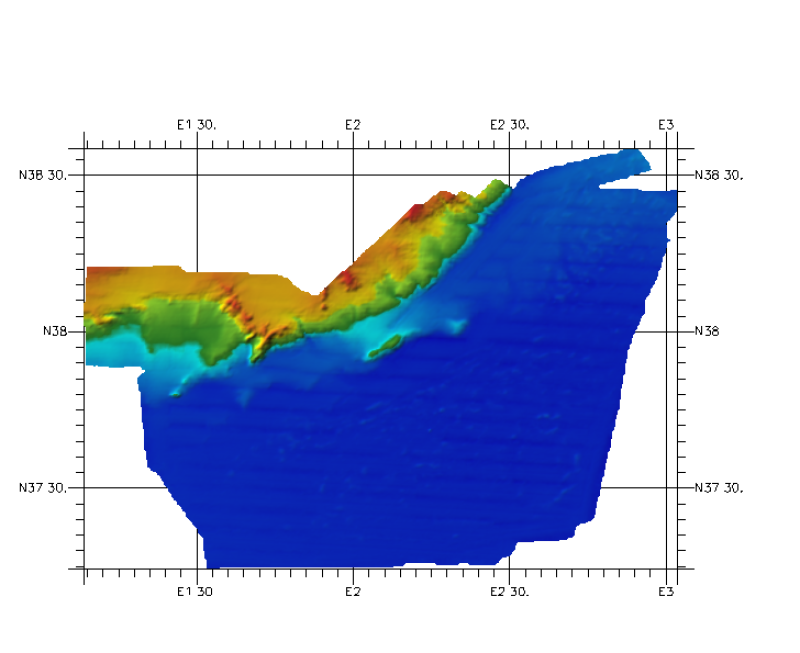
Composite DTM of Balear Islands, south margin, at approximately 200m of resolution
What
Metadata details
- File identifier
- SDN_CPRD_353_291003
- Catalogue type
-
Composite Product Record
-
Project name
-
-
EMODNet Hydrography
-
- Dissemination level
-
public
- Metadata language
- English
- Date stamp
- 2018-01-29T16:33:00
Identification
- Dataset name
-
353_291003-Balear Islands South Margin
- Short name of dataset (SDN Local Product-ID)
-
291003
-
Parameter Discovery Vocabulary (P02)
-
-
Bathymetry and Elevation
-
-
SeaDataNet device categories
-
-
multi-beam echosounders
-
-
SeaDataNet device categories
-
-
Differential Global Positioning System receivers
-
Geometry
- Spatial representation type
- Grid
- Pixel size
- 0.002 Degrees north (degree_north)
- Maximum scale of use
- 200000
Abstract
- Dataset description abstract
-
Composite DTM of Balear Islands, south margin, at approximately 200m of resolution
- Description of processed data sources
-
Description of processed data sources :
This DTM has been elaborated from one grid (ArcGis raster format), treated with the IDW method . The grid of 200 x 200 meters of resolution is derived from a RESON 8150 MBES survey made by OGS (R/V OGS EXPLORA ) with information about continental shelf and slope. The depths are between 1100 and 2800 meters. The vertical datum is Sea level.
- Description of data processing
-
Description of data processing :
Data were processed and filtered. A DTM was made by the data owner with 200x200 meters of resolution. This DTM was transformed to Geographic Coordinates with the PROJECT command of ArcGis software, with a resolution of 0,0020 decimal degrees.
Quality
Accuracy / Calibration
Hor. accuracy
- Measure description
-
Not specified
- Evaluation method description
-
In all case, multiple tests have been made in order to use the method which would introduce less error in the result
Vert. accuracy
- Measure description
-
Not specified
- Evaluation method description
-
In all case, multiple tests have been made in order to use the method which would introduce less error in the result.
Suitability
- Suitability, Expected type of users / uses and limitations
-
Not for navigation
Quality Indicators
- Horizontal Quality Indicator
- -1 - Multisources
- Vertical Quality Indicator
- -1 - Multisources
- Purpose Quality Indicator
- 2 - Bathymetric/morphologic survey
Where
))
- Min. depth in meters (>0 below Sea Level)
- 1144
- Max. depth in meters (>0 below Sea Level)
- 2841
Projection
- code
-
WGS 84 (EPSG:4326)
- Version or custom projection details
-
7.4
When
Creation date
Revision date
Temporal extent*
- Begin
- 2005-04-01T12:00:00
- End
- 2005-10-01T12:00:00
Who
Originator
- Organisation name
-
Istituto Espanol de Oceanografia (IEO)
Data Holding Center
- Organisation name
-
Istituto Espanol de Oceanografia (IEO)
Collating Centre = Metadata author
- Organisation name
-
Istituto Espanol de Oceanografia (IEO)
Access
Distributor
- Organisation name
-
Istituto Espanol de Oceanografia (IEO)
Data formats*
- Format
-
ESRI GRD
- Version
-
not specified
- OnLine resource
-
Protocol Linkage Name WWW:LINK
http://www.ieo.es/ Web site of the stituto Espanol de Oceanografia (IEO)
Intellectual property
- Access constraints
- Restricted
- Use constraints
- Copyright
- Other constraints
-
Contact ideo@ieo.es
)))