353_291101-ZEE_GALICIA
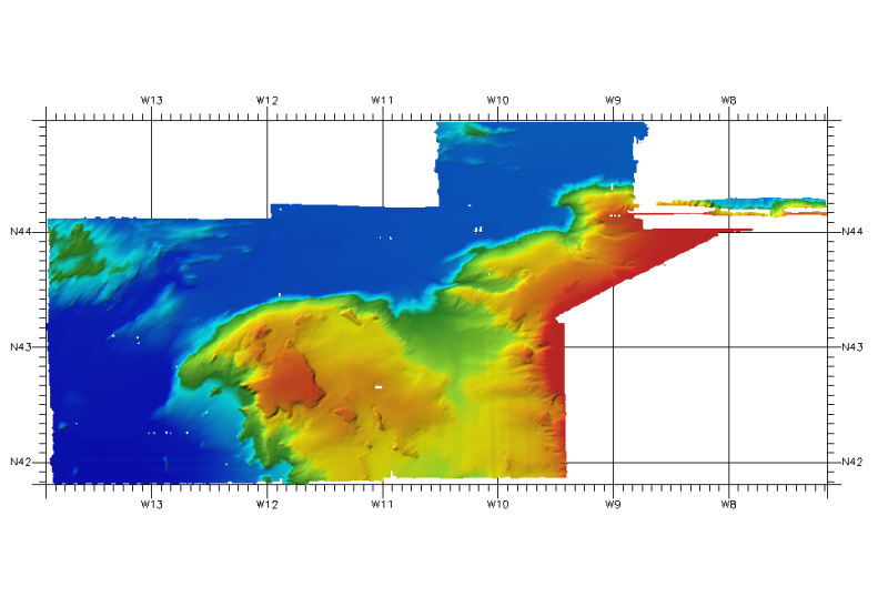
DTM of northwest cantabric margin, approximately 462,77 m. resolution.
What
Metadata details
- File identifier
- SDN_CPRD_353_291101
- Catalogue type
-
Composite Product Record
-
Project name
-
-
EMODNet Seabed Mapping
-
- Dissemination level
-
public
- Metadata language
- English
- Date stamp
- 2018-01-29T16:51:35
Identification
- Dataset name
-
353_291101-ZEE_GALICIA
- Short name of dataset (SDN Local Product-ID)
-
291101
-
Parameter Discovery Vocabulary (P02)
-
-
Bathymetry and Elevation
-
-
SeaDataNet device categories
-
-
multi-beam echosounders
-
-
SeaDataNet device categories
-
-
Differential Global Positioning System receivers
-
Geometry
- Spatial representation type
- Grid
- Pixel size
- 0.004167 Degrees north (degree_north)
- Maximum scale of use
- 200000
Abstract
- Dataset description abstract
-
DTM of northwest cantabric margin, approximately 462,77 m. resolution.
- Description of processed data sources
-
Description of processed data sources :
the data sources have been obtained from surveys property of IHM (Navy Hydrographic Institute).The measuring instruments are GPSD Seastart and Seapath-204 for positioning and MBES SIMRAD EM-120 - EM-12 & EM-1002 for echosounding.
- Description of data processing
-
Description of data processing :
No tide correction have been applied to the soundings obtained from IHM.
The received information was processed with Caris HIPS and SHIPS to create the GRID. From the surveys we extracted the .xyz files to make the DTM in angular coordinates at a resolution of 1/16 arc-minute of latitude and longitude. With this GRID we calculated the depth parameters (statistics). From the DTM at a resolution of 1/16 arc-minute, we have re-processed the information again with Caris HIPS and SHIPS to obtain the DTM of ¼ arc-minute
- Processing software
-
Caris HIPS and SHIPS
Quality
Accuracy / Calibration
Hor. accuracy
- Measure description
-
Not provided
- Evaluation method description
-
In all the cases, the owner of the information has made the quality controls for every zone
Vert. accuracy
- Measure description
-
Not provided
- Evaluation method description
-
In all the cases, the owner of the information has made the quality controls for every zone
Suitability
- Suitability, Expected type of users / uses and limitations
-
Not for navigation.
Contact josel.sanz@md.ieo.es
Quality Indicators
- Horizontal Quality Indicator
- 1 - Between 500m and 50m
- Vertical Quality Indicator
- 2 - MBES low frequency (lower than 100kHz) (similar than 1+2%d)
- Purpose Quality Indicator
- 2 - Bathymetric/morphologic survey
Where
))
- Min. depth in meters (>0 below Sea Level)
- 144
- Max. depth in meters (>0 below Sea Level)
- 5385
Projection
- code
-
WGS 84 (EPSG:4326)
- Version or custom projection details
-
7.4
When
Creation date
Revision date
Temporal extent*
- Begin
- 2005-01-01T12:00:00
- End
- 2009-01-01T12:00:00
Who
Originator
- Organisation name
-
Istituto Espanol de Oceanografia (IEO)
Data Holding Center
- Organisation name
-
Istituto Espanol de Oceanografia (IEO)
Collating Centre = Metadata author
- Organisation name
-
Istituto Espanol de Oceanografia (IEO)
Access
Distributor
- Organisation name
-
Istituto Espanol de Oceanografia (IEO)
Data formats*
- Format
-
ESRI GRD
- Version
-
Not specified
- OnLine resource
-
Protocol Linkage Name WWW:LINK
http://www.ieo.es/ Web site of the Istituto Espanol de Oceanografia (IEO)
Intellectual property
- Access constraints
- Restricted
- Use constraints
- Copyright
- Other constraints
-
Contact josel.sanz@md.ieo.es
)))