353_291102-ECOMARG
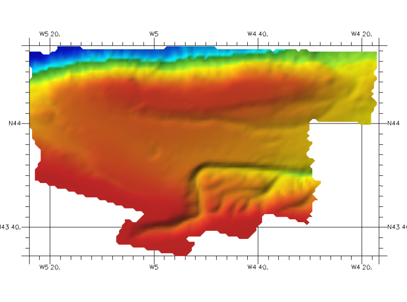
DTM of the northern cantabric margin, approximately 200 m. resolution. This DTM includes a band from 30 kilometres of the coast.
What
Metadata details
- File identifier
- SDN_CPRD_353_291102
- Catalogue type
-
Composite Product Record
-
Project name
-
-
EMODNet Seabed Mapping
-
- Dissemination level
-
public
- Metadata language
- English
- Date stamp
- 2018-01-29T16:43:06
Identification
- Dataset name
-
353_291102-ECOMARG
- Short name of dataset (SDN Local Product-ID)
-
291102
-
Parameter Discovery Vocabulary (P02)
-
-
Bathymetry and Elevation
-
-
SeaDataNet device categories
-
-
multi-beam echosounders
-
-
SeaDataNet device categories
-
-
Differential Global Positioning System receivers
-
Geometry
- Spatial representation type
- Grid
- Pixel size
- 0.002 Degrees north (degree_north)
- Maximum scale of use
- 200000
Abstract
- Dataset description abstract
-
DTM of the northern cantabric margin, approximately 200 m. resolution. This DTM includes a band from 30 kilometres of the coast.
- Description of processed data sources
-
Description of processed data sources :
Data sources were collected by IEO coordinated by Sea General Secretary (Ministerio de Medio Ambiente Rural y Marino de España). The measuring instruments were GPSD Seastart and Seapath-204 for positioning and MBES SIMRAD EM-300 for echosounding. Data have been supplied as ASCII GRID files processed with ARCGIS.
at a resolution of 100 m x 100 m.
- Description of data processing
-
Description of data processing :
The DTM made available has been extracted from the 100mx100m GRID (Argis raster format) using the RESAMPLE method of interpolation to make the DTM in angular coordinates at a resolution of 1/8 arc-minute of latitude and longitude.
- Processing software
-
ARC GIS
Quality
Accuracy / Calibration
Hor. accuracy
- Evaluation method description
-
In all the cases, the owner of the information has made the quality controls for every zone.
Vert. accuracy
- Evaluation method description
-
In all the cases, the owner of the information has made the quality controls for every zone.
Suitability
- Suitability, Expected type of users / uses and limitations
-
Not for navigationContact ideo@ieo.es
Quality Indicators
- Horizontal Quality Indicator
- 1 - Between 500m and 50m
- Vertical Quality Indicator
- 2 - MBES low frequency (lower than 100kHz) (similar than 1+2%d)
- Purpose Quality Indicator
- 2 - Bathymetric/morphologic survey
Where
))
- Min. depth in meters (>0 below Sea Level)
- 128
- Max. depth in meters (>0 below Sea Level)
- 4609
Projection
- code
-
WGS 84 (EPSG:4326)
- Version or custom projection details
-
7.4
When
Creation date
Revision date
Temporal extent*
- Begin
- 2003-01-01T12:00:00
- End
- 2004-12-31T12:00:00
Who
Originator
- Organisation name
-
Istituto Espanol de Oceanografia (IEO)
Data Holding Center
- Organisation name
-
Istituto Espanol de Oceanografia (IEO)
Collating Centre = Metadata author
- Organisation name
-
Istituto Espanol de Oceanografia (IEO)
Access
Distributor
- Organisation name
-
Istituto Espanol de Oceanografia (IEO)
Data formats*
- Format
-
ESRI GRID
- Version
-
Not specified
- OnLine resource
-
Protocol Linkage Name WWW:LINK
http://www.ieo.es/ Web site of the Istituto Espanol de Oceanografia (IEO)
Intellectual property
- Access constraints
- Restricted
- Use constraints
- Copyright
- Other constraints
-
Contact ideo@ieo.es
)))