353_291103 - MARCONI
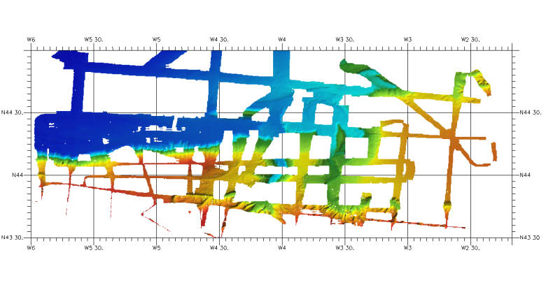
DTM of north cantabrian sea margin, approximately 460 m resolution. This DTM includes the whole area of Cantabria and part of Asturias one (depth from 100 to 4847,8m).
What
Metadata details
- File identifier
- SDN_CPRD_353_291103
- Catalogue type
-
Composite Product Record
-
Project name
-
-
EMODNet Seabed Mapping
-
- Dissemination level
-
public
- Metadata language
- English
- Date stamp
- 2018-01-18T13:09:23
Identification
- Dataset name
-
353_291103 - MARCONI
- Short name of dataset (SDN Local Product-ID)
-
291103
-
Parameter Discovery Vocabulary (P02)
-
-
Bathymetry and Elevation
-
-
Measuring devices
-
-
multi-beam echosounders
-
-
Measuring devices
-
-
Differential Global Positioning System receivers
-
Geometry
- Spatial representation type
- Grid
- Pixel size
- 0.004167 Degrees north (degree_north)
- Maximum scale of use
- 200000
Abstract
- Dataset description abstract
-
DTM of north cantabrian sea margin, approximately 460 m resolution. This DTM includes the whole area of Cantabria and part of Asturias one (depth from 100 to 4847,8m).
- Description of processed data sources
-
Description of processed data sources :
The DTM is derived from SIMRAD EM-120 and EM-12 multibeam echosounder surveys using GPSD Seastart and Seapath-204 for positioning. The source data have been obtained from ICM-CSIC as ASCII ArcGIS GRID files at a resolution of 100 m x 100 m.
- Description of data processing
-
Description of data processing :
The DTM has been extracted from the ICM-CSIC GRID (Argis raster format) using the RESAMPLE method of interpolation to convert it to angular coordinates at a resolution of 1/4 arc-minute of latitude and longitude.
- Processing software
-
ArcGIS
Quality
Accuracy / Calibration
Hor. accuracy
- Evaluation method description
-
In all the cases, the owner of the information has made the quality controls for every zone
Vert. accuracy
- Evaluation method description
-
In all the cases, the owner of the information has made the quality controls for every zone
Suitability
- Suitability, Expected type of users / uses and limitations
-
Not for navigation
Contact josel.sanz@md.ieo.es
Where
))
- Min. depth in meters (>0 below Sea Level)
- 100
- Max. depth in meters (>0 below Sea Level)
- 4848
Projection
- code
-
WGS 84 (EPSG:4326)
- Version or custom projection details
-
7.4
When
Creation date
Revision date
Temporal extent*
- Begin
- 2003-01-01T12:00:00
- End
- 2003-12-31T12:00:00
Who
Originator
- Organisation name
-
Istituto Espanol de Oceanografia (IEO)
Data Holding Center
- Organisation name
-
Istituto Espanol de Oceanografia (IEO)
Collating Centre = Metadata author
- Organisation name
-
Istituto Espanol de Oceanografia (IEO)
Access
Distributor
- Organisation name
-
Istituto Espanol de Oceanografia (IEO)
Data formats*
- Format
-
ESRI GRID
- Version
-
not specified
- OnLine resource
-
Protocol Linkage Name WWW:LINK
http://www.ieo.es/ Web site of the Istituto Espanol de Oceanografia (IEO)
Intellectual property
- Access constraints
- Restricted
- Use constraints
- Copyright
- Other constraints
-
Contact josel.sanz@md.ieo.es
)))