353_291105 - Cantabric Sea
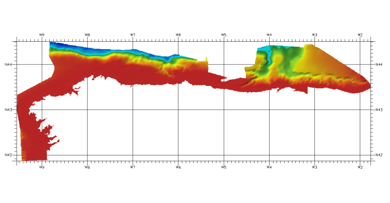
DTM of continental margin of Cantabric Sea, approximately 200 m resolution. This DTM includes the whole area from coast line to deepest level (5216,74 m).
What
Metadata details
- File identifier
- SDN_CPRD_353_291105
- Catalogue type
-
Composite Product Record
-
Project name
-
-
EMODNet Seabed Mapping
-
- Dissemination level
-
public
- Metadata language
- English
- Date stamp
- 2018-01-18T13:09:25
Identification
- Dataset name
-
353_291105 - Cantabric Sea
- Short name of dataset (SDN Local Product-ID)
-
291105
-
Parameter Discovery Vocabulary (P02)
-
-
Bathymetry and Elevation
-
-
Measuring devices
-
-
single-beam echosounders
-
multi-beam echosounders
-
-
Measuring devices
-
-
Differential Global Positioning System receivers
-
Geometry
- Spatial representation type
- Grid
- Number of columns
- 1966
- Number of lines
- 633
- Maximum scale of use
- 200000
Abstract
- Dataset description abstract
-
DTM of continental margin of Cantabric Sea, approximately 200 m resolution. This DTM includes the whole area from coast line to deepest level (5216,74 m).
- Description of processed data sources
-
Description of processed data sources :
Depth data have been obtained as isobaths from several sources.
- Description of data processing
-
Description of data processing :
The information was processed with ARCGIS software to create a DTM at a resolution of 200 m x 200 m. approximately. The IEO got this information in vectorial format as isobaths with different equidistance, from coast line or 0 meters to 5216,74 meters, according to depth. From this isobaths using the TOPOGRID (command for interpolation a DTM from isobaths) we made a DTM in angular coordinates at a resolution of 1/8 arc-minute of latitude and longitude.
- Processing software
-
ARcGIS
Quality
Accuracy / Calibration
Hor. accuracy
- Measure description
-
Not specified
Vert. accuracy
- Measure description
-
Not specified
Suitability
- Suitability, Expected type of users / uses and limitations
-
Not for navigation
Where
))
- Min. depth in meters (>0 below Sea Level)
- 0
- Max. depth in meters (>0 below Sea Level)
- 5216
Projection
- code
-
WGS 84 (EPSG:4326)
- Version or custom projection details
-
7.4
When
Creation date
Revision date
Temporal extent*
- Begin
- 1974-01-01T12:00:00
- End
- 2010-01-02T12:00:00
Who
Originator
- Organisation name
-
Instituto Espanol de Oceanografia (IEO)
Data Holding Center
- Organisation name
-
Instituto Espanol de Oceanografia (IEO)
Collating Centre = Metadata author
- Organisation name
-
Instituto Espanol de Oceanografia (IEO)
Access
Distributor
- Organisation name
-
Instituto Espanol de Oceanografia (IEO)
Data formats*
- Format
-
ESRI Grd
- Version
-
10.2
- OnLine resource
-
Protocol Linkage Name WWW:LINK
http://www.ieo.es/ Web site of the Instituto Espanol de Oceanografia (IEO)
Intellectual property
- Access constraints
- Restricted
- Use constraints
- Copyright
- Other constraints
-
Contact ideo@ieo.es
)))