NHS 50m grid from multibeam surveys processed in WGS84 UTM zone 32
Data created from 50*50m grids in UTM zone 32 based on modern multibeam surveys in this area in SW Norway, From 2016 this dataset is integrated into updated Mareanogrid-data and no longer useful
What
Metadata details
- File identifier
- SDN_CPRD_543_NHS-50m-grid_UTM32
- Catalogue type
-
Composite Product Record
-
Project name
-
-
EMODNet Hydrography
-
- Dissemination level
-
public
- Metadata language
- English
- Date stamp
- 2018-03-15T10:43:13
Identification
- Dataset name
-
NHS 50m grid from multibeam surveys processed in WGS84 UTM zone 32
- Short name of dataset (SDN Local Product-ID)
-
NHS-50m-grid_UTM32
-
Parameter Discovery Vocabulary (P02)
-
-
Bathymetry and Elevation
-
-
Measuring devices
-
-
multi-beam echosounders
-
-
Measuring devices
-
-
Global Navigation Satellite System receivers
-
Geometry
- Spatial representation type
- Grid
- Pixel size
- 50 Metres (m)
- Maximum scale of use
- 50000
Abstract
- Dataset description abstract
-
Data created from 50*50m grids in UTM zone 32 based on modern multibeam surveys in this area in SW Norway, From 2016 this dataset is integrated into updated Mareanogrid-data and no longer useful
- Description of processed data sources
-
Description of processed data sources :
- Description of data processing
-
Description of data processing :Done by TIN models, NHS internal software based on SYBASE database
- Processing software
-
Varde
Quality
Accuracy / Calibration
Hor. accuracy
- Value
- 2
Suitability
- Suitability, Expected type of users / uses and limitations
-
_not to be used for navigation_
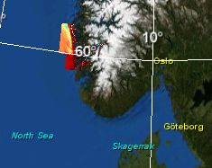
Where
))
- Min. depth in meters (>0 below Sea Level)
- 0.5
- Max. depth in meters (>0 below Sea Level)
- 860
Projection
- code
-
WGS 84 (EPSG:4326)
- Version or custom projection details
-
7.4
When
Creation date
Revision date
Temporal extent*
- Begin
- 1991-01-01T00:00:00
- End
- 2014-01-09T00:00:00
Who
Originator
- Organisation name
-
Norwegian Hydrographic Service
Data Holding Center
- Organisation name
-
Norwegian Hydrographic Service
Collating Centre = Metadata author
- Organisation name
-
EDMO name
Access
Distributor
- Organisation name
-
Norwegian Hydrographic Service
Data formats*
- Format
-
ASCII xyz
- Version
-
0
Intellectual property
- Use limitation
-
_not to be used for navigation_
- Access constraints
- License
- Use constraints
- Copyright
)))