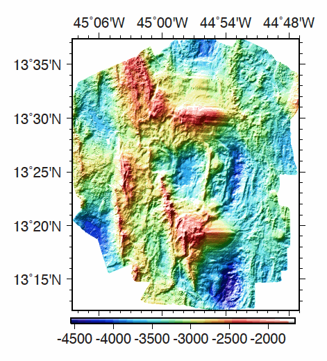
ODEMAR shipboard Pourquoi Pas? multibeam bathymetry
Multibeam bathymetry data, gridded at 40m, acquired around the 13°20'N and 13°30'N oceanic detachments along the Mid-Atlantic Ridge. Bathymetric data was acquired by the PourQUoi Pas? multibeam system (RESON 7150).
Data is provided as a grid in GRD format (GMT NETCDF).
| Date(s) Date(s) |
|
| Author(s) Auteur(s) |
Escartin Javier
(
IPGP/CNRS
)
|
| Contact(s) Contact(s) |
Ifremer
|
| Lineage Généalogie |
grdinfo of the file: ODEMAR_Shipboard_Bathymetry_40m.grd: Title: Bathy_40m.grd ODEMAR_Shipboard_Bathymetry_40m.grd: Command: File written by MATLAB function grdwrite2.m ODEMAR_Shipboard_Bathymetry_40m.grd: Remark: Created 22-Nov-2014 16:35:13 ODEMAR_Shipboard_Bathymetry_40m.grd: Gridline node registration used [Cartesian grid] ODEMAR_Shipboard_Bathymetry_40m.grd: Grid file format: nf = GMT netCDF format (32-bit float), COARDS, CF-1.5 ODEMAR_Shipboard_Bathymetry_40m.grd: x_min: -45.14293893 x_max: -44.77177893 x_inc: 0.00036 name: x nx: 1032 ODEMAR_Shipboard_Bathymetry_40m.grd: y_min: 13.20017553 y_max: 13.62389553 y_inc: 0.00036 name: y ny: 1178 ODEMAR_Shipboard_Bathymetry_40m.grd: z_min: -4498.29248047 z_max: -1935.33117676 name: z ODEMAR_Shipboard_Bathymetry_40m.grd: scale_factor: 1 add_offset: 0 ODEMAR_Shipboard_Bathymetry_40m.grd: format: classic |
| Constraints Contraintes |
|
| Spatial informations Informations géographiques |
|
Citation proposal Proposition de citation
Escartin Javier (2017).ODEMAR shipboard Pourquoi Pas? multibeam bathymetry.Ifremer
https://doi.org/10.12770/adfc0b11-f15f-468b-a7cb-0886a1645a0d
)))