IWWOC Antarctic Sea Ice Backscatter Gridded Level 3 Composite from SCAT onboard CFOSAT
Backscatter values over sea ice are a function of incidence angle and the sea ice type. With several SCAT incidence measurements, an incidence adjustment is mandatory over sea ice (Gohin and Cavanié 1994) to map daily averaged backscatter values accurately for geophysical use as it was done for the NSCAT Ku-band sensor. An incidence-adjustment backscatter map at 40° incidence angle is thus built in order to have reliable daily averaged backscatter maps.
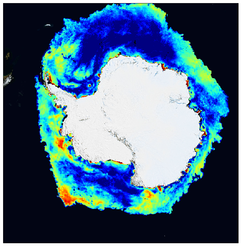
This dataset contains antarctic polar stereographic 12 km resolution grids of averaged backscatter coefficient from SCAT onboard CFOSAT scatterometer over sea-ice, for each polarization (HH and VV). CFOSAT (Chinese French Ocean SATellite) is a french-chinese mission launched in 2018, whose aim is to provide wind (SCAT instrument) and wave (SWIM instrument) measurements over the sea surface.
The grids are derived from swath sigma-naught data (CWWIC SCAT Level 1A product), averaged over one day. Sea ice roughness from the scatterometer backscatter can be used later for sea ice type detection (multi-year ice, first-year ice), sea ice edge (by discriminating open water from sea-ice) and later sea ice displacement maps . In the case of CFOSAT, the HH and VV polarization ratio can be used for sea ice studies, in particular sea ice edge criteria and ice type classification.
Access to the data is free and open. In order to be informed about changes and to help us keep track of data usage, we encourage users to register at: https://forms.ifremer.fr/lops-siam/access-to-iwwoc-cfosat-data/
This dataset is generated and distributed by IFREMER / CERSAT in the frame of the IFREMER Wind and Wave Operation Center (IWWOC) co-funded by IFREMER and CNES and dedicated to the processing of the delayed mode data of CFOSAT mission.
Simple
Identification info
- Date (Publication)
- 2022-02-09
- Citation identifier
- IWWOC_SCA_L3ICE_ANTARCTIC
- Point of contact
-
Organisation Individual Electronic mail address ORCID Role IFREMER
Fanny Ardhuin
Principal investigator IFREMER/CERSAT > Satellite Data Processing and Distribution Center of the French Research Institute for Exploitation of the Sea
Distributor IFREMER/CERSAT > Satellite Data Processing and Distribution Center of the French Research Institute for Exploitation of the Sea
Originator IFREMER/CERSAT > Satellite Data Processing and Distribution Center of the French Research Institute for Exploitation of the Sea
Funder IFREMER/CERSAT > Satellite Data Processing and Distribution Center of the French Research Institute for Exploitation of the Sea
CERSAT Help Desk
Point of contact CNES > Centre National d'Etudes Spatiales
Funder
- Spatial representation type
- Grid
Spatial resolution
- Spatial resolution
- 12.5 km
- Temporal resolution
-
P0Y0M1DT0H0M0S
Extent
))
- Geographic identifier
- Antarctic
Extent
- Time period
- 2020-05-28
- GEMET - INSPIRE themes, version 1.0
-
-
Oceanographic geographical features
-
- Cersat - Parameter
-
-
Sea Ice
-
- Cersat - Project
-
-
CFOSAT
-
IWWOC
-
- Cersat - Latency
-
-
Less than 4 days
-
- Cersat - GCMD parameter
-
-
/Sea Ice/Ice Extent
-
/Sea Ice/Ice Roughness
-
- Centre de données ODATIS
-
-
CDS-SAT-CERSAT
-
- Type de jeux de donnée ODATIS
-
-
Observational data
-
- Thèmatiques ODATIS
-
-
Remote sensing
-
Resource constraints
- Access constraints
- OtherRestrictions
- Use constraints
- These data were obtained from the Centre de Recherche et d'Exploitation Satellitaire (CERSAT), at IFREMER, Plouzané (France)
- Other constraints
- CC-BY (Creative Commons - Attribution)
- Other constraints
-
IFREMER / CERSAT. 2022. Antarctic Sea Ice Backscatter Gridded Level 3 Composite from SCAT onboard CFOSAT for IWWOC project. Ver. 1.0. IFREMER, Plouzane, France. Dataset accessed [YYYY-MM-DD]
Content Information
- Attribute description
- composite
- Processing level code
- L3
Distribution Information
- Distribution format
-
-
NetCDF
-
- OnLine resource
-
IFREMER FTP server
FTP
- OnLine resource
-
IFREMER HTTPS server
HTTPS
- OnLine resource
-
User guide
Product User Manual
- OnLine resource
-
Local path on Datarmor
Local path
- OnLine resource
-
Digital Object Identifier (DOI)
Data quality info
- Hierarchy level
- Series
Reference System Information
Identifier
- Code
- EPSG:3976
- Description
-
WGS 84 / NSIDC Sea Ice Polar Stereographic South (EPSG:3976)
- Instrument
-
Instrument Platform RFSCAT
CFOSAT
Metadata
- Metadata identifier
- urn:uuid/1241fd87-dfc6-4be1-9bfe-7bc222f9d785
- Language
- English
- Character encoding
- UTF8
- Contact
-
Organisation Individual Electronic mail address ORCID Role CERSAT Exploitation
Editor
Type of resource
- Resource type
- Series
- Metadata linkage
-
https://sextant.ifremer.fr/geonetwork/srv/api/records/1241fd87-dfc6-4be1-9bfe-7bc222f9d785
- Date info (Revision)
- 2024-06-13T14:07:46.725Z
- Date info (Creation)
- 2022-02-14T16:22:29.964Z
Metadata standard
- Title
-
ISO 19115-3:2018 - Remote Sensing
accessData
Overviews
Spatial extent
)))