Water Framework Directive monitoring (WFD)
The Water Framework Directive 2000/60/CE is applied to all European Union member states and establishes a new framework for community policy in the water sector with a view to improving management of aquatic environments.
Simple
Identification info
- Date (Creation)
- 2006-01-01T00:00:00
- Citation identifier
- FR-DCSMM-PDS-DCE
- Presentation form
- Digital profile
- Purpose
-
The general objective of the WFD, by 2015, is to reach a Good Environmental and Chemical Status of surface and underground water masses, including coastal waters and transitionary areas (in particular estuaries). Member states must therefore report any additional deterioration, and preserve and improve the state of aquatic ecosystems.
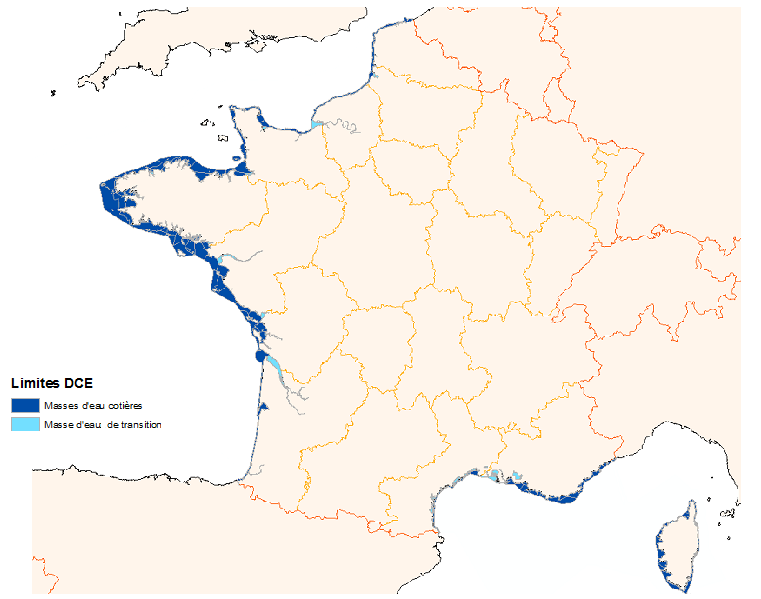
Coastal and transitional water masses are coherent geographical units, defined on the basis of physical criteria with a marked influence on biology:
- hydrodynamic criteria (current, tidal range, stratification, depth, etc.)
- sediment criteria (sand, mud, rock, etc.)
Using these criteria it is also possible to typify water masses (moderately exposed muddy coast, deep macro-tidal rocky coast, etc.).
Article 8 of the WFD foresees the implementation of a monitoring programme for water masses, in order to "draw up a coherent and complete table of the states of water within each hydrographic basin". This programme takes place over the duration of a "management plan", i.e. 6 years. In order to meet this objective, each hydrographic basin thus defined different networks of controls within the framework of Water Dater Master Plans (SDDE) as decreed by the ministerial circular from the Environment Ministy (MEEDDM), 26 March 2002.
- Credit
-
Data producers: Ifremer, RESOMAR, Irstea
- Status
- On going
- Point of contact
-
Organisation Individual Electronic mail address ORCID Role IFREMER
MIOSSEC Laurence
Point of contact
- Spatial representation type
- Vector
Spatial resolution
Equivalent scale
- Denominator
- 50000
- Topic category
-
- Oceans
Extent
Extent
))
- Maintenance and update frequency
- Irregular
- Maintenance note
-
Network duration : perennial device
- Theme
-
-
Monitoring
-
Good Environmental Status
-
Chemical Status
-
Coastal waters
-
Transitionary areas waters
-
- GEMET - INSPIRE themes, version 1.0
-
-
Environmental monitoring facilities
-
- Sous-regions marines
-
-
National
-
- DCSMM : Type d'espace concerné
-
-
Pas d'espace particulier concerné
-
- DCSMM : Descripteurs
-
-
D1: Coastal benthic habitats
-
D4: Marine Food Webs
-
D5: Eutrophication
-
D8: Chemical contaminants
-
- DCSMM : Méthodes de recueil des données
-
-
Observation par point
-
Observation directe
-
Observation par transect
-
Télédétection
-
Interprétation de représentations iconographiques et/ou textuelles
-
- Thèmes Sextant
-
-
/Human Activities/Coastal monitoring networks
-
Resource constraints
- Access constraints
- Other restrictions
- Other constraints
-
Free and open access
Resource constraints
- Use limitation
-
Models to be viewed online
- Language
- Français
- Character encoding
- UTF8
- Supplemental Information
-
Contracting authority:
French water authorities (AEAP, AESN, AELB, AEAG, AERMC) for WFD monitoring 2006
Prime contractor:
IFREMER : Institut Français pour la Recherche et l'Exploitation de la MER
Backers : Water Authorities 2006
Brittany Regional Council2000
La Reunion Island Regional Environment Directorate 2008
Content Information
- Content type
Distribution Information
- Distribution format
-
- OnLine resource
-
Directive Cadre sur l'Eau (DCE)
- OnLine resource
-
Principales publications
Data quality info
- Hierarchy level
- Dataset
Report
Result
- Title
-
Inspire specifications
- Date (Creation)
- 2012-01-16
- Explanation
-
Non assessed
- Pass
- false
Resource lineage
- Lineage
-
2000 : Establishment of The Water Framework Directive
- Hierarchy level
- Dataset
Process step
- Description
-
Data type :
Phytoplankton
Flora other than phytoplankton Fauna
Physico-chemical parameters
Measured or observed parameters :
Chl a, abundance, taxonomic composition Macroalgae, Macrophytes, Angiosperm, Benthic invertebrates / fishes
Temperature, salinity, turbidity, dissolved oxygen, oxygène dissous, nutrients (N)
Parameters resolution :
By taxon
By site
Update frequency :
Every month, or once a month from June to September
Every year to once every 6 years
Once every 3 years
Once a month (with specifically targeted periods at times), every year or two years.
Process step
- Description
-
Sampling method : Spatial
Process step
- Description
-
associated devices :
REPHY , ROCCH (anciennement RNO), REBENT , RINBIO
Spatial representation info
- Topology level
- Geometry only
- Geometric object type
- Complex
- Geometric object count
- 0
Reference System Information
- Reference system identifier
- EPSG/WGS 84 (EPSG:4326)
Portrayal catalogue info
- Title
-
Contrôle de surveillance benthique de la Directive Cadre sur l’Eau (2000/60/CE)
- Date (Publication)
- 2008-01-01
- Cited responsible party
-
Organisation Individual Electronic mail address ORCID Role Ifremer
Nebout, T et al
Author
- Title
-
Bilan 2010 de la mise en oeuvre de la Directive Cadre sur l’Eau pour le bassin Artois-Picardie - Masses d’eau côtières et de transition du Nord, du Pas de Calais et de la Picardie
- Date (Publication)
- 2010-01-01
- Cited responsible party
-
Organisation Individual Electronic mail address ORCID Role Ifremer
Lefebvre, A et al
Author
- Title
-
Mise en place du réseau de surveillance benthique Rebent-DCE pour les districts hydrographiques Seine-Normandie et Artois-Picardie
- Date (Publication)
- 2006-01-01
- Cited responsible party
-
Organisation Individual Electronic mail address ORCID Role Ifremer
Guérin, L et al
Author
- Title
-
Contrôle de surveillance benthique de la Directive Cadre sur l’Eau (2000/60/CE) : Etat des lieux et propositions : District Seine-Normandie
- Date (Publication)
- 2007-01-01
- Cited responsible party
-
Organisation Individual Electronic mail address ORCID Role Ifremer
Guérin, L et al
Author
- Title
-
Directive Cadre sur l’eau - Bassin Loire-Bretagne - Contrôles de surveillance et opérationnel dans les masses d’eau côtières et de transition
- Date (Publication)
- 2010-01-01
- Cited responsible party
-
Organisation Individual Electronic mail address ORCID Role Ifremer
Oger-Jeanneret, H et al
Author
- Title
-
Mise en place d’un réseau de surveillance des organismes benthiques pour le District hydrographique Adour-Garonne - Proposition d’un réseau de surveillance pour l’application de la Directive Cadre « eau »
- Date (Publication)
- 2006-01-01
- Cited responsible party
-
Organisation Individual Electronic mail address ORCID Role Ifremer
Blanchet, H et al
Author
- Title
-
Projet de réseau de contrôle de surveillance à mettre en oeuvre au titre de la DCE dans le district Adour-Garonne
- Date (Publication)
- 2006-01-01
- Cited responsible party
-
Organisation Individual Electronic mail address ORCID Role Ifremer
Trut, G
Author
- Title
-
Directive Cadre sur l’Eau - District « Rhône et côtiers méditerranéens » - Contrôles de surveillance/opérationnel
- Date (Publication)
- 2010-01-01
- Cited responsible party
-
Organisation Individual Electronic mail address ORCID Role Ifremer
Andral, B et al
Author
- Title
-
Rhône et côtiers méditerranéens » et « Corse »- Contrôles de surveillance/opérationnel - Campagne DCE 2009
- Date (Publication)
- 2010-01-01
- Cited responsible party
-
Organisation Individual Electronic mail address ORCID Role Andral, B et al
Author
- Title
-
Optimisation de la surveillance des masses d’eau DCE en Méditerranée - Compléments d’utilisation d’imagerie satellite et application d’outils hydrodynamiques
- Date (Publication)
- 2010-01-01
- Cited responsible party
-
Organisation Individual Electronic mail address ORCID Role Ifremer
Ganzin, N et al
Author
Metadata constraints
- Classification
Metadata
- Metadata identifier
- 170a3072-1a12-4e91-85e1-74d4c5a8f73c
- Language
- Français
- Character encoding
- UTF8
- Language
- English
- Character encoding
- UTF8
- Contact
-
Organisation Individual Electronic mail address ORCID Role Sextant
Point of contact
Type of resource
- Resource type
- Series
- Metadata linkage
-
https://sextant.ifremer.fr/geonetwork/srv/api/records/170a3072-1a12-4e91-85e1-74d4c5a8f73c
- Date info (Creation)
- 2014-06-04T11:38:53Z
- Date info (Revision)
- 2025-05-15T21:29:14.201453Z
Metadata standard
- Title
-
ISO 19115-3 - SEXTANT
- Edition
-
1.0
accessData
Overviews
Spatial extent
)))