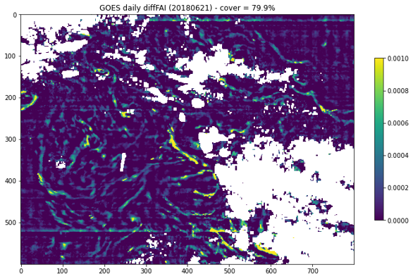
Maps of Sargassum detection from GOES-16 over the Atlantic
Maps of sargassum detection index NFAI (Normalized Floating Algae Index) using OLCI ocean color sensor onboard Sentinel-3A & Sentinel -3B satellites. Maps are delivered at 1km resolution in the Tropical Atlantic (included Gulf of Mexico) as instantaneous map acquired every 10 minutes (High resolution product) or on a daily basis averaging the 60 instantaneous maps (acquired every 10 minutes between 10:00 and 19:50 ITC).
The variables available in the products are:
- for dm dataset : fai_anomaly_daily_mean = floating algae index anomaly daily mean
- for hr dataset : fai_anomaly = floating algae index anomaly
Simple
Identification info
- Date (Creation)
- 1994-01-04
- Date (Publication)
- 2022-05-16
- Credit
-
AVISO+
- Point of contact
-
Organisation Individual Electronic mail address ORCID Role CDS-AVISO
Point of contact CLS
Originator CDS-AVISO
Distributor CNES
Funder Hygeos
Originator
- Spatial representation type
- Grid
Spatial resolution
- Spatial resolution
- 1 km
- Topic category
-
- Oceans
Extent
))
Extent
- Time period
- 2022-03-01
- Variables ODATIS
-
-
/Marine Biology/Macroalgae and seagrass
-
Resource constraints
- Use limitation
- Licence ouverte
- Access constraints
- Other restrictions
- Use constraints
- Other restrictions
- Other constraints
-
Any use of this dataset must be verified in the AVISO+ license and must cite its DOI 10.24400/527896/a01-2022.008. The Floating sargassum algae detection product has been produced by CLS and Hygeos with support from CNES, distributed by CDS-AVISO.
- Language
- Français
- Character encoding
- UTF8
Content Information
- Processing level code
- /L4
Distribution Information
- Distribution format
-
-
NetCDF-4
-
- OnLine resource
-
Plus d'information sur AVISO+
Further information
- OnLine resource
-
fai_anomaly_daily_mean
floating_algae_index_anomaly_daily_mean
- OnLine resource
-
floating algae index anomaly daily mean ABI GOES - NRT- DM
THREDDS
- OnLine resource
-
Manuel utilisateur AVISO+
Handbook AVISO+
- OnLine resource
-
fai_anomaly
floating_algae_index_anomaly
- OnLine resource
-
floating algae index anomaly ABI GOES - NRT- HR
THREDDS
- OnLine resource
-
Seewater
- OnLine resource
-
Digital Object Identifier (DOI)
Resource lineage
- Lineage
-
Since 2011, unprecedent massive landings of sargassum seaweed (Sargassum fluitans and Sargassum natans) have been observed along the shorelines of a huge area encompassing the Gulf of Mexico, the Caribbean Sea and West Africa, having tremendous negative impacts over local communities.
Satellite imagery allows to detect the presence of floating sargassum and is a key tool to help scientists to understand the origin and the seasonality of the sargassum movements in the Atlantic, and to support local communities in the management of the next sargassum influxes.
The basic processing of the observations from the Advanced Baseline Imager (ABI) sensor onboard the GOES16 geostationary satellite is performed by the new software designed by Hygeos and operated by CLS since March 2022. The chief advantage of this geostationary satellite is the capability to acquire one image every 10 min over a visibility circle centered on the 75W meridian, thus covering the Atlantic ocean from the Gulf of Mexico to the offshore of Western Africa. This capability offers a much greater probability to measure the ocean surface within one day, which is not the case for sun-synchronous satellites. The daily spatial coverage improves by a factor of 2 to 3 thanks to the daily movement of the clouds, compared to a single slot. The multi-temporal observation also provides the ability to monitor the evolution of the sargassum position. The drawback is the much-reduced radiometric sensitivity of the sensor, together with the coarser pixel resolution (1 km), compared to the ocean colour sensors typically used for sargassum monitoring (OLCI on Sentinel-3A & 3B, MODIS or Sentinel-2). The sargassum index used by Hygeos is the FAI anomaly, which is the difference between the pixel FAI (Hu, 2009) and a background FAI value of sargassum-free FAI. This index also includes several steps to enhance the data quality: radiometric correction, masking and denoising.
References:
- Hu, C., 2009 : A novel ocean color index to detect floating algae in the global oceans. Rem. Sensing of Environment 113, 2118-2129. DOI : https://doi.org/10.1016/j.rse.2009.05.012
- Hierarchy level
- Dataset
Spatial representation info
- Geometric object type
- Complex
Reference System Information
- Reference system identifier
- http://www.opengis.net/def/crs/EPSG/0/4326
- Instrument
-
Instrument Platform ABI
GOES-16
Metadata
- Metadata identifier
- urn:uuid/1b02a152-0707-42c8-9071-2b4866692f97
- Language
- Français
- Character encoding
- UTF8
- Language
- English
- Character encoding
- UTF8
Type of resource
- Resource type
- Dataset
- Metadata linkage
-
https://sextant.ifremer.fr/geonetwork/srv/api/records/1b02a152-0707-42c8-9071-2b4866692f97
- Date info (Creation)
- 2023-12-06T14:16:54.656Z
- Date info (Revision)
- 2025-02-24T13:24:49.888713Z
Metadata standard
- Title
-
ISO 19115-3:2018 - Remote Sensing
- Edition
-
1.0
accessData
Overviews
Spatial extent
)))