Atlas des lieux de surveillance
Atlas cartographique présentant l'ensemble des dispositifs de collecte des programmes de surveillance
Simple
Identification info
- Date (Creation)
- 2021-06-21
- Citation identifier
- FR-SIMM-ATLAS-LIEUX-SURVEILLANCE
- Presentation form
- Digital profile
- Purpose
-
The aim of this network is to produce biological indices in order to characterise the status and the short-term evolution of species and populations of interest to fisheries. Among other things, these campaigns are conducted with a view to developing the ecosystem approach to fishing. Six annual campaigns (around 200 days at sea) focusing on demersal and pelagic resources are contracted with the EU within the framework of DCF regulations. Fisheries observation campaigns are carried out in accordance with standardised observation protocols drawn up for each series. When the series are conducted within the framework of programmes carried out in partnership with another country (IBTS in the North Sea and MEDITS in the Mediterranean for example), the protocols are common to all coordinating countries. Furthermore, care is taken to harmonise observation methods between series (in the north-east Atlantic and in the North Sea, at the heart of the CIEM). Generally, the standardised elements are: the sampling gear (including the entire rig for trawlers), the distribution of sampling locations, observation period and frequency, the sampling operation process, sample analysis and data storage format. At Ifremer, the first series of standardised observation began in the late 1970s.
- Credit
-
Data producers : IFREMER
- Status
- On going
- Point of contact
-
Organisation Individual Electronic mail address ORCID Role Milieu Marin France
Point of contact
- Spatial representation type
- Vector
- Topic category
-
- Environment
Extent
Extent
- Time period
- 1980-10-15
Extent
))
- Maintenance and update frequency
- Annually
- Maintenance note
-
Network duration : perennial network
- Theme
-
-
Eggs and larvae
-
Dispositifs
-
- GEMET - INSPIRE themes, version 1.0
-
-
Environmental monitoring facilities
-
- Sous-regions marines
-
-
National
-
- DCSMM : Descripteurs
-
-
D10: Marine Litter
-
D1: Biodiversité - Mammifères
-
D1: Biodiversity
-
D1: Birds, Marine Mammals and Turtles
-
D3: Commercially Exploited Species
-
D1: Deep-sea benthic habitats
-
D2: Non-indigenous species
-
D4: Marine Food Webs
-
D5: Eutrophication
-
D8: Chemical contaminants
-
D7: Hydrographical Conditions
-
D6: Sea-floor Integrity
-
D9: Health Issues
-
ET : Environmental Targets
-
- Thèmes Sextant
-
-
/Human Activities/Coastal monitoring networks
-
- Thématiques - SIMM
-
-
/Environmental Status/Geology
-
/Environmental Status/Habitats
-
/Environmental Status/Hydrodynamics
-
/Environmental Status/Coastal areas
-
/Environmental Status/Pollution
-
/Environmental Status/Species
-
Research
-
/Etat du Milieu/Bathymétrie
-
/Environmental Status/Biogeochemistry
-
- Cadre Réglementaire - SIMM
-
-
Directive Cadre pour la Planification de l'Espace Maritime (DCPEM)
-
Directive Cadre Stratégie pour le Milieu Marin (DCSMM)
-
Directive Cadre sur l'Eau (DCE)
-
Politique Commune des Pêches
-
Resource constraints
- Access constraints
- Other restrictions
- Use constraints
- Copyright
- Other constraints
-
Données sous Licence Creative Commons - Attribution + Pas d’Utilisation Commerciale + Pas de Modification (BY-NC-ND) : http://creativecommons.org/licenses/
- Language
- Français
- Character encoding
- UTF8
- Supplemental Information
-
Project leader :
IFREMER 1976
Prime contractor :
IFREMER 1976
Backers :
Electricité De France - EDF 1993
IFREMER 1976
European union 1976
Content Information
- Content type
Distribution Information
- Distribution format
-
-
ESRI Shapefile
-
- OnLine resource
-
SIMM
- OnLine resource
-
simm_lieux_sextant_point
SIMM - Atlas des lieux (point)
- OnLine resource
-
simm_lieux_sextant_point
SIMM - Atlas des lieux (point)
- OnLine resource
-
simm_lieux_sextant_line
SIMM - Atlas des lieux (ligne)
- OnLine resource
-
simm_lieux_sextant_line
SIMM - Atlas des lieux (ligne)
- OnLine resource
-
simm_lieux_sextant_polygone
SIMM - Atlas des lieux (polygone)
- OnLine resource
-
simm_lieux_sextant_polygone
SIMM - Atlas des lieux (polygone)
Data quality info
- Hierarchy level
- Dataset
Report
Result
- Title
-
Inspire specifications
- Date (Creation)
- 2012-01-16
- Explanation
-
non assessed
- Pass
- false
Resource lineage
- Hierarchy level
- Dataset
Spatial representation info
- Geometric object type
Metadata
- Metadata identifier
- 50cc5e71-0bf6-46d4-81dc-dfeda1707c82
- Language
- Français
- Character encoding
- UTF8
- Language
- English
- Character encoding
- UTF8
- Contact
-
Organisation Individual Electronic mail address ORCID Role Sextant
Point of contact
Type of resource
- Resource type
- Series
- Metadata linkage
-
https://sextant.ifremer.fr/geonetwork/srv/api/records/50cc5e71-0bf6-46d4-81dc-dfeda1707c82
- Date info (Creation)
- 2021-06-21T15:35:07Z
- Date info (Revision)
- 2025-05-15T22:22:23.295384Z
Metadata standard
- Title
-
ISO 19115-3 - SEXTANT
- Edition
-
1.0
accessData
Overviews
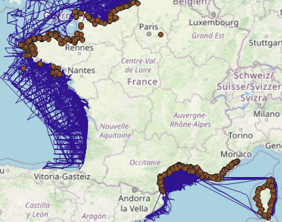
Spatial extent
)))