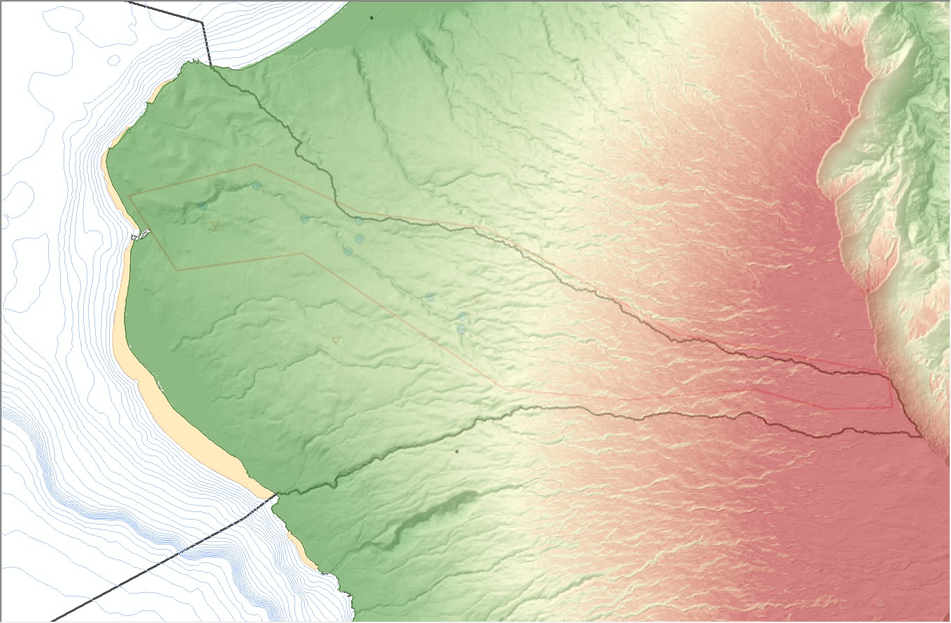
Modèle numérique de terrain (MNT) à 10m centré sur la zone d'étude couverte par le modèle de ruissellement "HYDROGFX" développé dans le cadre du projet GIML à La Réunion.
Le modèle de ruissellement "Hydrogfx" développé dans le cadre du projet GIML permet de simuler le ruissellement de l'eau de pluie sur un bassin versant. On fournit en entrée de simulation un modèle numérique de terrain qui sert à calculer les pentes et à influencer le ruissellement en conséquence.
Simple
Identification info
- Date (Creation)
- 2015-06-10
- Citation identifier
- FR_33159627000297_CIRAD_GIML-MNT_10m_HYDROGFX
- Credit
-
GIML (CIRAD)
- Status
- Historical archive
- Point of contact
-
Organisation Individual Electronic mail address ORCID Role CIRAD
Point of contact Point of contact
- Spatial representation type
- Grid
Spatial resolution
Equivalent scale
- Denominator
- 25000
- Topic category
-
- Society
Extent
))
- Maintenance and update frequency
- As needed
- Place
-
-
océan indien
-
La Réunion
-
TCO
-
- Theme
-
-
Gestion Intégrée mer et littoral
-
- GEMET - INSPIRE themes, version 1.0
-
-
Buildings
-
Elevation
-
Oceanographic geographical features
-
Geographical names
-
Geology
-
Hydrography
-
Habitats and biotopes
-
Agricultural and aquaculture facilities
-
Environmental monitoring facilities
-
Production and industrial facilities
-
Orthoimagery
-
Land cover
-
Cadastral parcels
-
Sea regions
-
Bio-geographical regions
-
Population distribution — demography
-
Species distribution
-
Transport networks
-
Utility and governmental services
-
Human health and safety
-
Protected sites
-
Soil
-
Administrative units
-
Land use
-
Natural risk zones
-
- Thèmes Sextant
-
-
/Milieu physique/Bathymétrie/MNT
-
Resource constraints
- Access constraints
- Copyright
- Use constraints
- Other restrictions
- Other constraints
-
Obligation de faire figurer les sources de la manière suivante : "Ces données ont été produites par le CIRAD, l'Université de La Réunion, l'Ifremer et dans le cadre du projet GIML (Gestion Intégrée de la Mer et de Littoral) soutenu par le TCO."
Resource constraints
- Use limitation
-
Données sous Licence Creative Commons - Attribution + Pas d’Utilisation Commerciale + Partage dans les mêmes conditions (BY-NC-SA) : http://creativecommons.fr/licences/
- Language
- Français
- Character encoding
- UTF8
Distribution Information
- Distributor contact
-
Organisation Individual Electronic mail address ORCID Role Ifremer - Centre de Brest
Administrateur du serveur Sextant
Distributor
- Date
Data quality info
- Hierarchy level
- Dataset
Report
Result
- Title
-
Inspire specifications
- Date (Creation)
- 2012-01-16
- Explanation
-
Non évalué
- Pass
- false
Resource lineage
- Lineage
-
Fichier produit dans le cadre du développement du modèle "Hydrogfx" et susceptible d'être modifié à volonté par les utilisateurs du modèle.
- Hierarchy level
- Dataset
Spatial representation info
- Number of dimensions
- 2
- Dimension name
- Row
- Dimension size
- 2023
- Resolution
- 10
- Dimension name
- Column
- Dimension size
- 1494
- Resolution
- 10
- Cell geometry
- Area
- Transformation parameter availability
- false
Reference System Information
- Reference system identifier
- EPSG/WGS 84 / UTM zone 40S (EPSG:32740)
Metadata
- Metadata identifier
- 62b79a47-d131-41de-aed1-d658cf58421f
- Language
- Français
- Character encoding
- UTF8
- Contact
-
Organisation Individual Electronic mail address ORCID Role TCO
Point of contact CIRAD
Point of contact
Type of resource
- Resource type
- Dataset
- Metadata linkage
-
https://sextant.ifremer.fr/geonetwork/srv/api/records/62b79a47-d131-41de-aed1-d658cf58421f
- Date info (Creation)
- 2015-06-15T11:51:40Z
- Date info (Revision)
- 2025-05-15T22:38:34.590244Z
Metadata standard
- Title
-
ISO 19115-3 - SEXTANT
- Edition
-
1.0
accessData
Overviews
Spatial extent
)))