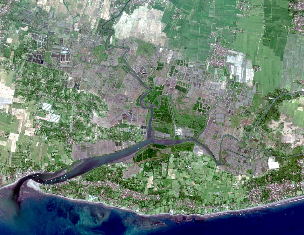
High resolution satellite imagery - Perancak - March 26th, 2014
Worldview-2 satellite images from Perancak site acquired during the INDESO project on March 26th, 2014.
They are composed of 4 channels (infrared, red, green and blue) with a 2m spatial resolution and one panchromatic image with a 0.5m resolution.
A mosaicing and clipping treatment of all images available is provided in visualization. Each channel can be download for Indeso project partners.
Simple
Identification info
- Date (Publication)
- 2015-05-18
- Citation identifier
- IFR_NEW_CAL_INDESO_SAT_PERANCAK_26MAR2014
- Presentation form
- Digital image
- Purpose
-
Dataset acquired during the Indeso project, for shrimp application development of indicators for sustainable aquaculture in Indonesia and mangrove application.
- Credit
-
CLS
- Credit
-
Digital globe
- Credit
-
Balitbang
- Status
- Completed
- Point of contact
-
Organisation Individual Electronic mail address ORCID Role IRD - UMR AMAP
Christophe Proisy
Originator Ifremer
Benoit Soulard
Custodian Balitbang
Berny Subki
Owner
- Spatial representation type
- Grid
Spatial resolution
Equivalent scale
- Denominator
- 2500
- Topic category
-
- Imagery base maps earth cover
Extent
))
Extent
- Time period
- 2014-03-26T02:57:00 2014-03-26T02:57:00
- Maintenance and update frequency
- Not planned
- Thèmes Sextant
-
-
/Imagery/Satellite Imagery
-
- GEMET - INSPIRE themes, version 1.0
-
-
Installations agricoles et aquacoles
-
- Place
-
-
Perancak
-
Resource constraints
- Use limitation
-
Restricted use for Indeso project
- Access constraints
- License
- Use constraints
- Restricted
- Language
- Français
- Character encoding
- UTF8
Distribution Information
- Distributor contact
-
Organisation Individual Electronic mail address ORCID Role Ifremer - Sextant
Administrateur du serveur Sextant
Resource provider
- Title
-
TIFF
- Date
Data quality info
- Hierarchy level
- Dataset
Report
Result
- Title
-
Inspire specifications
- Date (Publication)
- 2015-05-18
- Explanation
-
Non évalué
- Pass
- false
Resource lineage
- Lineage
-
Images provided by CLS:
Products references :
- 14MAR26025742-M2AS-053728342110_01_P003
- 14MAR26025742-P2AS-053728342110_01_P003
- Hierarchy level
- Dataset
Spatial representation info
- Number of dimensions
- 2
- Dimension name
- Row
- Dimension size
- 8852
- Dimension name
- Column
- Dimension size
- 11388
- Cell geometry
- Area
- Transformation parameter availability
- false
Reference System Information
- Reference system identifier
- EPSG/WGS 84 / UTM zone 50S (EPSG:32750)
Metadata
- Metadata identifier
- 68db4823-8280-4d69-87dd-9bfafa69a4ae
- Language
- Français
- Character encoding
- UTF8
- Language
- English
- Character encoding
- UTF8
- Contact
-
Organisation Individual Electronic mail address ORCID Role Ifremer
Benoit Soulard
Author
Type of resource
- Resource type
- Dataset
- Metadata linkage
-
https://sextant.ifremer.fr/geonetwork/srv/api/records/68db4823-8280-4d69-87dd-9bfafa69a4ae
- Date info (Creation)
- 2015-05-18T04:10:41Z
- Date info (Revision)
- 2025-05-15T22:43:53.444369Z
Metadata standard
- Title
-
ISO 19115-3 - SEXTANT
- Edition
-
1.0
accessData
Overviews
Spatial extent
)))