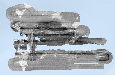
Rétrodiffusion du fond marin - canyon de Capbreton (campagne SEDYMAQ3, 2012)
Rétrodiffusion du fond marin du canyon de Capbreton, dans le golfe de Gascogne (campagne SEDYMAQ3 en 2012), au pas de 1 mètre. Les données ont été acquises par le sondeur multifaisceau EM2040 du N/O Thalia.
Description de la campagne : GILLET Hervé (2012) SEDYMAQ3 cruise, RV Thalia, https://doi.org/10.17600/12070080
Simple
Identification info
- Date (Publication)
- 2025-04-22
- Date (Creation)
- 2017-04-28
- Citation identifier
- https://sextant.ifremer.fr/record/7c02b2a1-df4f-405c-8e2f-12180bbf237f
- Credit
-
UMR CNRS 5805 EPOC - OASU
- Point of contact
-
Organisation Individual Electronic mail address ORCID Role Ifremer
Ifremer Geo-Ocean
Author Ifremer
Publisher
- Spatial representation type
- Grid
Spatial resolution
Equivalent scale
- Denominator
- 2000
Spatial resolution
- Spatial resolution
- 1 meter
- Topic category
-
- Oceans
Extent
))
Extent
- Time period
- 2012-06-03 2012-06-11
- Discipline
-
-
Backscatter
-
Resource constraints
- Use limitation
- CC-BY (Creative Commons - Attribution)
- Access constraints
- Other restrictions
- Use constraints
- License
- Other constraints
-
Pas de restriction d'accès public
- Language
- Français
- Character encoding
- UTF8
Distribution Information
- Distribution format
-
-
GeoTIFF
-
OnLine resource
- Protocol
-
COPYFILE
- Name of the resource
-
SEDYMAQ3_Capbreton_1m_BACKSCATTER
- Description
-
SEDYMAQ3_Capbreton_1m_BACKSCATTER
- OnLine resource
-
SEDYMAQ3_Capbreton_1m_BACKSCATTER
SEDYMAQ3 : rétrodiffusion du fond marin du canyon de Capbreton
- OnLine resource
-
SEDYMAQ3_Capbreton_1m_BACKSCATTER
SEDYMAQ3_Capbreton_1m_BACKSCATTER
Data quality info
- Hierarchy level
- Dataset
Report
Result
- Title
-
RÈGLEMENT (UE) N o 1089/2010 DE LA COMMISSION du 23 novembre 2010 portant modalités d'application de la directive 2007/2/CE du Parlement européen et du Conseil en ce qui concerne l'interopérabilité des séries et des services de données géographiques
- Date (Publication)
- 2010-12-08
- Explanation
-
See the referenced specification
Resource lineage
- Lineage
-
Traitements réalisés : Ifremer CTDI/GM C. Guérin, 2016.
- Hierarchy level
- Dataset
Spatial representation info
- Number of dimensions
- 2
- Dimension name
- Column
- Dimension size
- 6483
- Dimension name
- Row
- Dimension size
- 3969
- Cell geometry
- Area
Reference System Information
Identifier
- Code
- WGS84/ WORLD MERCATOR (EPSG3395) latitude 44°N
- Codespace
-
EPSG
- Version
-
7.4
Metadata
- Metadata identifier
- 7c02b2a1-df4f-405c-8e2f-12180bbf237f
- Language
- Français
- Character encoding
- UTF8
- Language
- English
- Character encoding
- UTF8
- Contact
-
Organisation Individual Electronic mail address ORCID Role Ifremer
Geo-Ocean
Point of contact
Type of resource
- Resource type
- Dataset
- Metadata linkage
-
https://sextant.ifremer.fr/geonetwork/srv/api/records/7c02b2a1-df4f-405c-8e2f-12180bbf237f
- Date info (Creation)
- 2024-08-02T07:16:15.824Z
- Date info (Revision)
- 2025-05-15T22:59:45.890414Z
Metadata standard
- Title
-
ISO 19115-3 - SEXTANT
- Edition
-
1.0
accessData
Overviews
Spatial extent
)))