Mesoscale eddy trajectory atlas product - Near Real Time
Multimission altimetry-derived eddy trajectories in NRT (for Near-Real-Time).
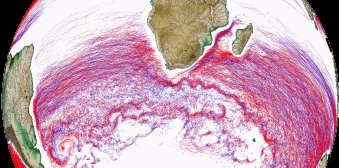
Eddies detected from the multimission altimetry datasets, with location each day giving the type (cyclonic/anticyclonic), speed, radius and associated metadata, for the altimetry period: 01/01/2018 - ongoing with15 days delay.
- Center position (Longitude and latitude of the center of the best fit circle with the contour of maximum circum-average geostrophic speed);
- Amplitude (|SSH(local_extremum) – SSH(outermost_contour)|);
- Speed radius (Radius of the best fit circle with the contour of maximum circum-average geostrophic speed);
- Speed average (Average geostrophic speed of the contour defining the speed radius);
- Speed profile (Profile speed average values from effective contour inwards to smallest inner contour);
- Effective contour (Largest contour of the detected eddy);
- Speed contour (Contour of maximum circum-average geostrophic speed for the detected eddy).
Several versions exist: Delayed time "Twosat" and "Allsat", described on other metadata sheets. Links and cross references below.
The NRT product is based on ”all-satellite” input products, that allows a better sampling of the ocean at a given time. Indeed the focus on short period of time with a best sampling is in the interest of using a NRT product. For the NRT product, the eddy detection is made on ADT maps to avoid a) misinterpreting eddies with a permanent signature and b) that the displacement of large currents creates anomalies similar to eddies.
The algorithm used for this product is derived from the one described in Mason et al. (2014) and further described in Pegliasco et al. (2022).
The mesoscale circulation is defined as a class of energetic phenomena of spatial dimensions ranging from tens to hundreds of kilometers and spanning days to years. The mesoscale structures are mainly generated by currents instabilities, from the ocean large-scale circulation instabilities due to wind or topographic obstacles, creating variability around the ocean’s mean state.
References:
- Mason, E., Pascual, A., McWilliams, J.C., 2014. A New Sea Surface Height–Based Code for Oceanic Mesoscale Eddy Tracking. J. Atmospheric Ocean. Technol. 31, 1181–1188. https://doi.org/10.1175/JTECH-D-14-00019.1
- Pegliasco, C., Delepoulle, A., Mason, E., Morrow, R., Faugère, Y., Dibarboure, G., 2022. META3.1exp: a new global mesoscale eddy trajectory atlas derived from altimetry. Earth Syst. Sci. Data 14, 1087–1107. https://doi.org/10.5194/essd-14-1087-2022
- Visvalingam, M., Whyatt, J.D., 1992. Line generalisation by repeated elimination of the smallest area. Cartogr. Inf. Syst. Res. Group University of Hull.
Simple
Identification info
- Date (Creation)
- 2022-01-13
- Date (Publication)
- 2022-01-13
- Credit
-
AVISO+
- Point of contact
-
Organisation Individual Electronic mail address ORCID Role CDS-AVISO
Point of contact CDS-AVISO
Distributor IMEDEA
Funder CNES
Funder CLS
Originator
- Spatial representation type
- Grid
- Topic category
-
- Oceans
Extent
))
Extent
- Time period
- 2018-01-01
Vertical element
- Minimum value
- 0
- Maximum value
- 0
- Keywords
-
-
mesoscale eddies
-
Resource constraints
- Use limitation
- Licence
- Use limitation
-
Les conditions d'utilisation sont spécifiées dans la licence : https://www.aviso.altimetry.fr/fileadmin/documents/data/License_Aviso.pdf, Citation : "The altimetric Mesoscale Eddy Trajectory Atlas (META3.2exp NRT) product is produced by SSALTO/DUACS and distributed by CDS-AVISO+ (https://www.aviso.altimetry.fr/) with support from CNES, in collaboration with IMEDEA." We recommend specifying the date you access the dataset and the period covered.
- Access constraints
- Other restrictions
- Use constraints
- Other restrictions
- Other constraints
- Open Licence
- Other constraints
-
Citation : "The altimetric Mesoscale Eddy Trajectory Atlas (META3.2exp NRT) product is produced by SSALTO/DUACS and distributed by CDS-AVISO (https://www.aviso.altimetry.fr/) with support from CNES, in collaboration with IMEDEA." We recommend specifying the date you access the dataset and the period covered.
Associated resource
- Association Type
- Cross reference
- Metadata Reference
Associated resource
- Association Type
- Cross reference
- Metadata Reference
- Language
- Français
- Character encoding
- UTF8
Content Information
- Processing level code
- L4
Distribution Information
- Distribution format
-
-
NetCDF
-
- OnLine resource
-
Plus d'information sur AVISO+
Further information
- OnLine resource
-
Accès authentifié aux données via FTP
Authenticated access through FTP
- OnLine resource
-
Mesoscale Eddy Trajectories Atlas in Altimeter Observations
THREDDS
- OnLine resource
-
Manuel utilisateur NRT META3.2
Handbook NRT META3.2
- OnLine resource
-
Web link (URL)
Mesoscale eddy trajectory atlas product - Delayed Time - Twosat
- OnLine resource
-
Web link (URL)
Mesoscale eddy trajectory atlas product - Delayed Time - Allsat
- OnLine resource
-
Web link (URL)
Open source code and programming examples in Python
- OnLine resource
-
Eddy_trajectory_nrt_3.2exp_cyclonic
View (WMS)
- OnLine resource
-
Eddy_trajectory_nrt_3.2exp_anticyclonic
Eddy_trajectory_nrt_3.2exp_anticyclonic
Resource lineage
- Lineage
-
The NRT product is based on ”all-satellite” input products, that allows a better sampling of the ocean at a given time.
Indeed the focus on short period of time with a best sampling is in the interest of using a NRT product.
For the NRT product, the eddy detection is made on ADT maps to avoid a) misinterpreting eddies with a permanent signature and b) that the displacement of large currents creates anomalies similar to eddies.
The data used are ““all-satellite” daily Near Real Time DUACS (DT2021 version since 2021/12/08), with the variable "Gridded Global Absolute Dynamic Topographies (ADT)" from Copernicus Marine Service (CMEMS) http://marine.copernicus.eu/.
Several versions exist: Delayed time "Twosat" and "Allsat", described on other metadata sheets.
Types of dataset: multimission altimeter products.
Contents: multimission altimetry-derived eddy trajectories
Format : NetCDF-4 Classic with CF standards.
- Reading software: examples in Python programming language. Details on Aviso+ Users Newsletter #14, page 4: Tools for the Mesoscale Eddy Trajectory Atlas, https://www.aviso.altimetry.fr/fileadmin/documents/newsstand/Newsletter/aviso_newsletter_14.pdf#page=4
- Code delivery: the open source code and programming examples in Python are available at https://github.com/AntSimi/py-eddy-tracker from version META3.0 onwards. When using the code, please cite "The code used to compute the Mesoscale Eddy Trajectories Atlas from version 3.0 onwards, was developed in collaboration between IMEDEA (E. Mason) and CLS, is freely available under GNU General Public License github.com/AntSimi/py-eddy-tracker".
- Image of the month, June 2017: Eddies everywhere, https://www.aviso.altimetry.fr/en/news/image-of-the-month/2017/jun-2017-eddies-everywhere.html
References:
- Mason, E., Pascual, A., McWilliams, J.C., 2014. A New Sea Surface Height–Based Code for Oceanic Mesoscale Eddy Tracking. J. Atmospheric Ocean. Technol. 31, 1181–1188. https://doi.org/10.1175/JTECH-D-14-00019.1
- Pegliasco, C., Delepoulle, A., Mason, E., Morrow, R., Faugère, Y., Dibarboure, G., 2022. META3.1exp: a new global mesoscale eddy trajectory atlas derived from altimetry. Earth Syst. Sci. Data 14, 1087–1107. https://doi.org/10.5194/essd-14-1087-2022
- Visvalingam, M., Whyatt, J.D., 1992. Line generalisation by repeated elimination of the smallest area. Cartogr. Inf. Syst. Res. Group University of Hull.
- Hierarchy level
- Dataset
Spatial representation info
- Geometric object type
- Complex
Metadata
- Metadata identifier
- urn:uuid/daa20677-abe6-49c5-a47b-33f7ad399108
- Language
- Français
- Character encoding
- UTF8
- Language
- English
- Character encoding
- UTF8
Type of resource
- Resource type
- Dataset
- Metadata linkage
-
https://sextant.ifremer.fr/geonetwork/srv/api/records/daa20677-abe6-49c5-a47b-33f7ad399108
- Date info (Creation)
- 2023-12-06T14:16:40.706Z
- Date info (Revision)
- 2025-02-24T13:24:26.952803Z
Metadata standard
- Title
-
ISO 19115-3:2018 - Remote Sensing
- Edition
-
1.0
accessData
Overviews
Spatial extent
)))