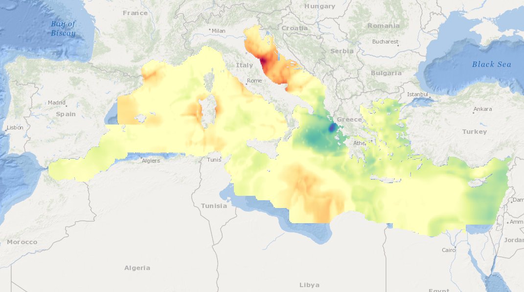
MEDSEA_CH6_Product_4 / Maps showing differences between most recent TRIX estimates (2008-2012) and TRIX from the earlier periods 1998-2002 and 1993-1997
TRIX differences between the periods 2008-2012 minus 1998-2002, and 2008-2012 minus 1993-1997, are provided.
Simple
Identification info
- Date (Creation)
- 2016-11-24T14:00:00
- Date (Revision)
- 2016-12-08T18:00:00
- Citation identifier
- DOI:10.12770/df305b0a-ca6e-4dc3-87e6-3b1f62b1d513
- Purpose
-
Map of trends of “eutrophication algorithm/indicator” from in situ data and FOR THE PAST 10 YEARS
- Credit
-
EMODnet Medsea Checkpoint
- Point of contact
-
Organisation Individual Electronic mail address ORCID Role Oceans.cat
Point of contact Oceans.cat
Point of contact EMODnet Medsea Checkpoint
Publisher Oceans.cat
Author CEAB-CSIC
Author
- Spatial representation type
- Grid
- Topic category
-
- Oceans
Extent
))
Extent
- Time period
- 1993-01-01T00:00:00 2012-12-31T00:00:00
Vertical element
- Minimum value
- 0
- Maximum value
- 5
- Used by challenges
-
-
MedSea - CH06 - Marine Environment
-
- Processing level of characteristics
-
-
High level analyzed
-
- Production mode
-
-
Delayed
-
- GEMET - INSPIRE themes, version 1.0
-
-
Oceanographic geographical features
-
- Theme
-
-
eutrophication index
-
historical data sets
-
maps
-
trends
-
Mediterranean Sea
-
Resource constraints
- Use limitation
-
open and free
- Use constraints
Associated resource
- Association Type
- Cross reference
- Initiative Type
- upstreamData
Associated resource
- Association Type
- Cross reference
- Initiative Type
- upstreamData
Associated resource
- Association Type
- Cross reference
- Initiative Type
- upstreamData
Associated resource
- Association Type
- Cross reference
- Initiative Type
- upstreamData
Associated resource
- Association Type
- Cross reference
- Initiative Type
- upstreamData
Associated resource
- Association Type
- Cross reference
- Initiative Type
- upstreamData
Associated resource
- Association Type
- Cross reference
- Initiative Type
- upstreamData
Associated resource
- Association Type
- Cross reference
- Initiative Type
- upstreamData
Associated resource
- Association Type
- Cross reference
- Initiative Type
- upstreamData
Associated resource
- Association Type
- Cross reference
- Initiative Type
- upstreamData
Associated resource
- Association Type
- Cross reference
- Initiative Type
- upstreamData
Associated resource
- Association Type
- Cross reference
- Initiative Type
- upstreamData
Associated resource
- Association Type
- Cross reference
- Initiative Type
- upstreamData
Associated resource
- Association Type
- Cross reference
- Initiative Type
- upstreamData
Associated resource
- Association Type
- Cross reference
- Initiative Type
- upstreamData
Associated resource
- Association Type
- Cross reference
- Initiative Type
- upstreamData
Associated resource
- Association Type
- Cross reference
- Initiative Type
- upstreamData
Associated resource
- Association Type
- Cross reference
- Initiative Type
- upstreamData
Associated resource
- Association Type
- Cross reference
- Initiative Type
- upstreamData
Associated resource
- Association Type
- Cross reference
- Initiative Type
- upstreamData
Associated resource
- Association Type
- Cross reference
- Initiative Type
- upstreamData
- Language
- English
- Character encoding
- UTF8
Distribution Information
- Distribution format
-
-
PDF
-
ESRI Shapefile
-
- OnLine resource
-
DOI of the product
DOI of the product
- OnLine resource
-
CH6_product_4
Product visualization
MEDSEA_CH6_Product_4 / Maps showing differences between most recent TRIX estimates (2008-2012) and TRIX from the earlier periods 1998-2002 and 1993-1997 - Map of trends of “eutrophication algorithm/indicator” from in situ data and FOR THE PAST 10 YEARS
- Begin date
- 1993-01-01T00:00:00
- End date
- 2002-12-31T00:00:00 After
Vertical element
- Minimum value
- 0
- Maximum value
- 5
Metadata
- Metadata identifier
- urn:uuid/df305b0a-ca6e-4dc3-87e6-3b1f62b1d513
- Language
- English
- Character encoding
- UTF8
Type of resource
- Resource type
- Dataset
- Metadata linkage
-
http://localhost:8080/geonetwork/srv/eng//metadata/286d8887-58a5-4562-a0b9-a69b78fced76
- Metadata linkage
-
http://localhost:8080/geonetwork/srv/eng//metadata/47dea01f-5b6a-48d7-990a-606a6001cbef
- Metadata linkage
-
https://sextant.ifremer.fr/geonetwork/srv/eng//metadata/df305b0a-ca6e-4dc3-87e6-3b1f62b1d513
- Metadata linkage
-
https://sextant.ifremer.fr/geonetwork/srv/fre//metadata/df305b0a-ca6e-4dc3-87e6-3b1f62b1d513
- Date info (Revision)
- 2017-08-24T12:30:00Z
- Date info (Creation)
- 2005-03-31T19:13:30
Metadata standard
- Title
-
ISO 19115-3 - Emodnet Checkpoint - Targeted Data Product
accessData
Overviews
Spatial extent
)))